Summary

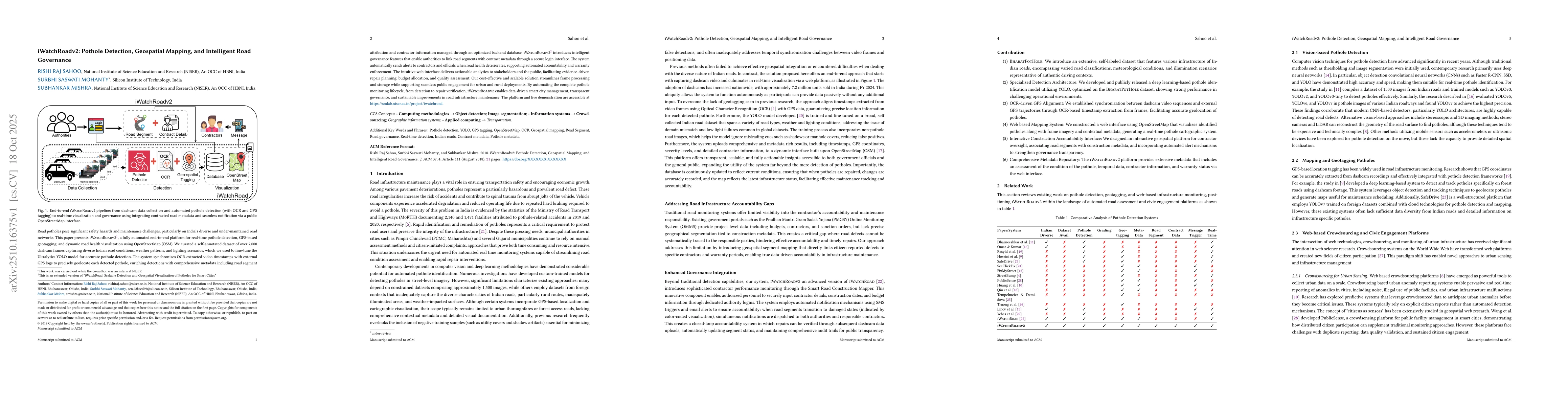
Road potholes pose significant safety hazards and maintenance challenges, particularly on India's diverse and under-maintained road networks. This paper presents iWatchRoadv2, a fully automated end-to-end platform for real-time pothole detection, GPS-based geotagging, and dynamic road health visualization using OpenStreetMap (OSM). We curated a self-annotated dataset of over 7,000 dashcam frames capturing diverse Indian road conditions, weather patterns, and lighting scenarios, which we used to fine-tune the Ultralytics YOLO model for accurate pothole detection. The system synchronizes OCR-extracted video timestamps with external GPS logs to precisely geolocate each detected pothole, enriching detections with comprehensive metadata, including road segment attribution and contractor information managed through an optimized backend database. iWatchRoadv2 introduces intelligent governance features that enable authorities to link road segments with contract metadata through a secure login interface. The system automatically sends alerts to contractors and officials when road health deteriorates, supporting automated accountability and warranty enforcement. The intuitive web interface delivers actionable analytics to stakeholders and the public, facilitating evidence-driven repair planning, budget allocation, and quality assessment. Our cost-effective and scalable solution streamlines frame processing and storage while supporting seamless public engagement for urban and rural deployments. By automating the complete pothole monitoring lifecycle, from detection to repair verification, iWatchRoadv2 enables data-driven smart city management, transparent governance, and sustainable improvements in road infrastructure maintenance. The platform and live demonstration are accessible at https://smlab.niser.ac.in/project/iwatchroad.

AI Key Findings

Generated Oct 29, 2025

Methodology

The research employs a deep learning framework integrating YOLO for pothole detection, OCR for timestamp extraction, and synchronized GPS data to map road conditions. It also utilizes OpenStreetMap for interactive visualization and incorporates crowdsourced data for real-time updates.

Key Results

  • The system achieves high accuracy in pothole detection with minimal false positives.
  • Integration of GPS and video timestamps improves geolocation precision by 5 decimal places.
  • Real-time monitoring enables timely maintenance alerts and transparent accountability.
  • Crowdsourced data enhances the system's coverage and responsiveness.

Significance

This research addresses critical infrastructure maintenance challenges by providing an automated, scalable solution for road condition monitoring. It supports intelligent transportation systems and contributes to sustainable urban development.

Technical Contribution

The integration of YOLO, OCR, and synchronized GPS data into a unified framework for automated pothole detection and road health governance.

Novelty

The unique combination of real-time road condition monitoring with official contract data, along with an interactive OpenStreetMap-based platform, distinguishes this work from existing solutions.

Limitations

  • Dependence on frequent vehicle traversal for verification may delay repair confirmation.
  • GPS-video synchronization requires precise calibration which can be challenging in varying time zones.
  • High computational demands may limit real-time processing capabilities on low-end devices.

Future Work

  • Expanding the system to include pavement distress classification and surface roughness estimation.
  • Integrating with IoT sensor networks and autonomous vehicle systems for enhanced data collection.
  • Developing advanced deduplication algorithms to handle redundant data from multiple contributors.

Paper Details

PDF Preview

Download PDF

Comments (0)

This website uses cookies to ensure you get the best experience. Learn more