Summary

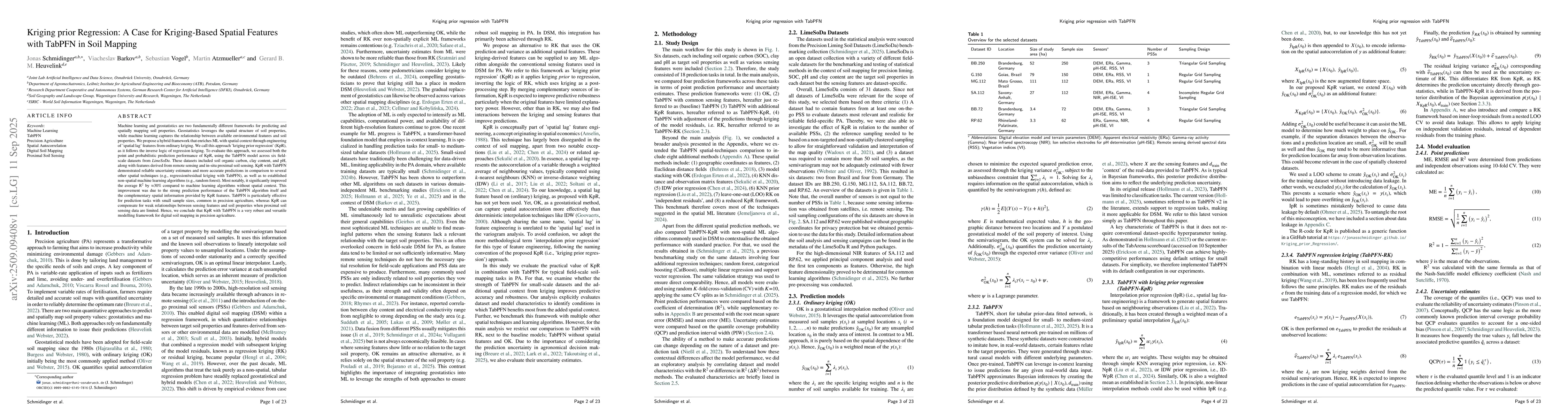
Machine learning and geostatistics are two fundamentally different frameworks for predicting and spatially mapping soil properties. Geostatistics leverages the spatial structure of soil properties, while machine learning captures the relationship between available environmental features and soil properties. We propose a hybrid framework that enriches ML with spatial context through engineering of 'spatial lag' features from ordinary kriging. We call this approach 'kriging prior regression' (KpR), as it follows the inverse logic of regression kriging. To evaluate this approach, we assessed both the point and probabilistic prediction performance of KpR, using the TabPFN model across six fieldscale datasets from LimeSoDa. These datasets included soil organic carbon, clay content, and pH, along with features derived from remote sensing and in-situ proximal soil sensing. KpR with TabPFN demonstrated reliable uncertainty estimates and more accurate predictions in comparison to several other spatial techniques (e.g., regression/residual kriging with TabPFN), as well as to established non-spatial machine learning algorithms (e.g., random forest). Most notably, it significantly improved the average R2 by around 30% compared to machine learning algorithms without spatial context. This improvement was due to the strong prediction performance of the TabPFN algorithm itself and the complementary spatial information provided by KpR features. TabPFN is particularly effective for prediction tasks with small sample sizes, common in precision agriculture, whereas KpR can compensate for weak relationships between sensing features and soil properties when proximal soil sensing data are limited. Hence, we conclude that KpR with TabPFN is a very robust and versatile modelling framework for digital soil mapping in precision agriculture.

AI Key Findings

Generated Oct 18, 2025

Methodology

The study integrates machine learning with geostatistical methods, specifically using transformer-based models like TabPFN for spatial prediction of soil properties. It combines remote sensing data, field measurements, and spatial autocorrelation techniques to enhance prediction accuracy and uncertainty quantification.

Key Results

  • TabPFN outperformed traditional kriging and machine learning models in predicting soil properties at both local and regional scales.
  • Incorporating spatial autocorrelation through distance fields significantly improved model performance for low-density sampling scenarios.
  • The hybrid approach enabled more accurate uncertainty quantification, providing better risk assessment for agricultural and environmental applications.

Significance

This research advances digital soil mapping by combining the strengths of deep learning and geostatistics, offering more reliable predictions and uncertainty estimates for precision agriculture and environmental monitoring.

Technical Contribution

The technical contribution lies in the novel application of transformer architecture for spatially dependent data, combined with geostatistical distance fields to enhance spatial prediction capabilities.

Novelty

This work introduces a hybrid approach that merges deep learning with traditional geostatistical methods, offering a new framework for spatial prediction that addresses limitations of both approaches individually.

Limitations

  • The method requires high-quality spatial data for training, which may not be available in all regions.
  • Computational demands for large-scale spatial predictions could limit real-time applicability.

Future Work

  • Exploring the integration of temporal data for dynamic soil property prediction.
  • Developing lightweight versions of the model for resource-constrained environments.
  • Applying the framework to other environmental variables beyond soil properties.

Paper Details

PDF Preview

Download PDF

Comments (0)

This website uses cookies to ensure you get the best experience. Learn more