Quick Summary:

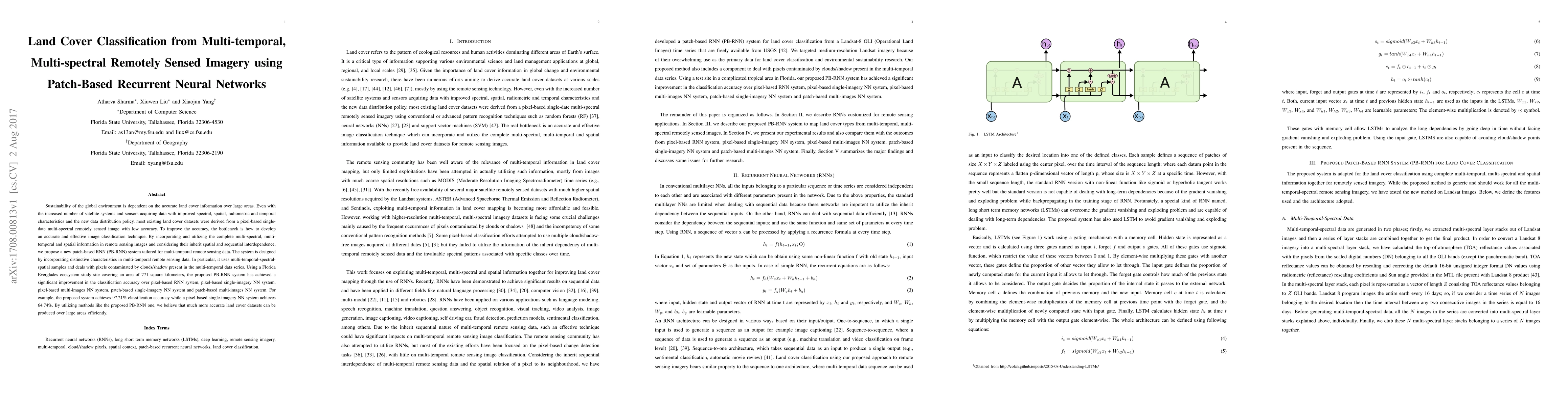
This paper proposes a patch-based recurrent neural network (PB-RNN) system for improved land cover classification from multi-temporal, multi-spectral remote sensing imagery. The PB-RNN system significantly outperforms existing pixel-based systems, achieving 97.21% classification accuracy in a Florida Everglades study, compared to 64.74% by a pixel-based single-imagery neural network system.

Summary

Sustainability of the global environment is dependent on the accurate land cover information over large areas. Even with the increased number of satellite systems and sensors acquiring data with improved spectral, spatial, radiometric and temporal characteristics and the new data distribution policy, most existing land cover datasets were derived from a pixel-based single-date multi-spectral remotely sensed image with low accuracy. To improve the accuracy, the bottleneck is how to develop an accurate and effective image classification technique. By incorporating and utilizing the complete multi-spectral, multi-temporal and spatial information in remote sensing images and considering their inherit spatial and sequential interdependence, we propose a new patch-based RNN (PB-RNN) system tailored for multi-temporal remote sensing data. The system is designed by incorporating distinctive characteristics in multi-temporal remote sensing data. In particular, it uses multi-temporal-spectral-spatial samples and deals with pixels contaminated by clouds/shadow present in the multi-temporal data series. Using a Florida Everglades ecosystem study site covering an area of 771 square kilo-meters, the proposed PB-RNN system has achieved a significant improvement in the classification accuracy over pixel-based RNN system, pixel-based single-imagery NN system, pixel-based multi-images NN system, patch-based single-imagery NN system and patch-based multi-images NN system. For example, the proposed system achieves 97.21% classification accuracy while a pixel-based single-imagery NN system achieves 64.74%. By utilizing methods like the proposed PB-RNN one, we believe that much more accurate land cover datasets can be produced over large areas efficiently.

AI Key Findings

Get AI-generated insights about this paper's methodology, results, and significance.

Paper Details

PDF Preview

Download PDF

Key Terms

nn (0.263)
pixel (0.246)
remote sensing (0.224)
pb (0.216)
patch (0.207)
temporal (0.207)
remote (0.192)
cover (0.183)
multi (0.182)
sensing (0.172)
spatial (0.154)
spectral (0.146)
incorporating (0.145)
accuracy (0.143)
utilizing (0.143)
classification (0.143)
areas (0.141)
images (0.136)
accurate (0.135)
single (0.125)
Title Authors Year Actions
Decadal analysis and simulation of land use and land cover changes in Taiwan using machine learning and markov chain models
Chun-ya Liu, Aman Arora
2024
View Paper
Satellite Image Time-Series Classification with Inception-Enhanced Temporal Attention Encoder
Zheng Zhang, Weixiong Zhang, Yu Meng, Zhitao Zhao, Ping Tang, Hongyi Li
2024
View Paper
Multi-Scale Patch Transformer Network for Satellite Image Time Series Classification
Jifeng Suo, Degang Wang
2024
View Paper
Identification and factor analysis of rocky desertification severity levels in large-scale karst areas based on deep learning image segmentation
Yuhao Wang, Xianghong Tang, Yong Huang, Jing Yang, Jiang Lu
2024
View Paper
Deep learning for urban land use category classification: A review and experimental assessment
Ziming Li, Bin Chen, Shengbiao Wu, Mo Su, Jing M. Chen, Bing Xu
2024
View Paper
Explaining the decisions and the functioning of a convolutional spatiotemporal land cover classifier with channel attention and redescription mining
Enzo Pelous, Nicolas Méger, Alexandre Benoit, A. Atto, Dino Ienco, Hermann Courteille, Christophe Lin-Kwong-Chon
2024
View Paper
Advancing horizons in remote sensing: a comprehensive survey of deep learning models and applications in image classification and beyond
Sidike Paheding, Ashraf Saleem, Mohammad Faridul Haque Siddiqui, Nathir Rawashdeh, Almabrok E. Essa, Abel A. Reyes
2024
View Paper
Xai-Guided Enhancement of Vegetation Indices for Crop Mapping
Hiba Najjar, F. Mena, M. Nuske, A. Dengel
2024
View Paper
Land Use/Cover Changes During 1992–2022 in the Yayo Coffee Forest Biosphere Reserve, Southwestern Ethiopia
Gemeda Terfassa Fida, B. Baatuuwie, H. Issifu
2024
View Paper
The forecast and low-carbon performance of land use in rapid urbanization area under the low-carbon oriented spatial planning: Evidence from Hangzhou, China
Weicheng Gu, Weifeng Qi, Mingyu Zhang
2024
View Paper
Federated learning meets remote sensing
S. Moreno-Álvarez, M. Paoletti, Andres J. Sanchez-Fernandez, Juan A. Rico-Gallego, Lirong Han, J. Haut
2024
View Paper
Development of a Knowledge-based Hierarchical Decision Tree Method for Classification of Croplands based on Cropping System in Google Earth Engine (case study: Sharekurd)
Alireza Taheri Dehkordi, Rohollah Goodarzi, Nohammad Javad Valadan Zoej
2024
View Paper
Large-scale land use/land cover extraction from Landsat imagery using feature relationships matrix based deep-shallow learning
Peng Dou, Huanfeng Shen, Chunlin Huang, Zhiwei Li, Yujun Mao, Xinghua Li
2024
View Paper
S2Mamba: A Spatial-spectral State Space Model for Hyperspectral Image Classification
Guanchun Wang, Xiangrong Zhang, Zelin Peng, Tianyang Zhang, Xiuping Jia, Licheng Jiao
2024
View Paper
A Comprehensive Survey for Hyperspectral Image Classification: The Evolution from Conventional to Transformers and Mamba Models
M. Ahmad, Salvatore Distifano, Adil Mehmood Khan, Manuel Mazzara, Chenyu Li, Hao Li, Jagannath Aryal, Yao Ding, G. Vivone, Danfeng Hong
2024
View Paper
Glacial retreat delineation using machine and deep learning: A case of a lower Himalayan region
Sriram Vemuri, Dhwanilnath Gautam, Shaily Gandhi
2024
View Paper
Optimized convolutional neural network for land cover classification via improved lion algorithm
Anusha Preetham, Sumit Vyas, Manoj Kumar, Sanjay Nakharu Prasad Kumar
2024
View Paper
Enhancing vegetation formation classification: Integrating coarse-scale traditional mapping knowledge and advanced machine learning.
Tao Zhang, Baolin Li, Yecheng Yuan, Xizhang Gao, Ji Zhou, Yuhao Jiang, Jie Xu, Yuyu Zhou
2024
View Paper
Deep learning in water protection of resources, environment, and ecology: achievement and challenges.
Xiaohua Fu, Jie Jiang, Xie Wu, Lei Huang, Rui Han, Kun Li, Chang Liu, Kallol Roy, Jianyu Chen, Nesma Talaat Abbas Mahmoud, Zhenxing Wang
2024
View Paper
Complex Real-Time Monitoring and Decision-Making Assistance System Based on Hybrid Forecasting Module and Social Network Analysis
Henghao Fan, Hongmin Li, Xiaoyang Gu, Zhongqiu Ren
2024
View Paper
Time-Series-Based Spatiotemporal Fusion Network for Improving Crop Type Mapping
Wenfang Zhan, Feng Luo, Heng Luo, Junli Li, Yongchuang Wu, Zhixiang Yin, Yanlan Wu, Penghai Wu
2024
View Paper
Synergistic exploitation of localized spectral-spatial and temporal information with DNNs for multisensor-multitemporal image-based crop classification
G. S. Phartiyal, Dharmendra Singh, Hussein Yahia
2023
View Paper
Soil Moisture Prediction Using Deep Learning on Hyperspectral Data
Sourav Seal, Divyashikha Sethia
2023
View Paper
Deep Learning for blind spectral unmixing of LULC classes with MODIS multispectral time series and ancillary data
J. Rodríguez-Ortega, Rohaifa Khaldi, D. Alcaraz‐Segura, S. Tabik
2023
View Paper
A Study on Wetland Cover Map Formulation and Evaluation Using Unmanned Aerial Vehicle High-Resolution Images
Tai Yang Lim, Jiyun Kim, Wheemoon Kim, Wonkyong Song
2023
View Paper
Automatically drawing vegetation classification maps using digital time‐lapse cameras in alpine ecosystems
Ryotaro Okamoto, R. Ide, H. Oguma
2023
View Paper
Application of Deep Learning in Multitemporal Remote Sensing Image Classification
Xinglu Cheng, Yonghua Sun, Wangkuan Zhang, Yihan Wang, Xuyue Cao, Yanzhao Wang
2023
View Paper
Active learning based on similarity level histogram and adaptive-scale sampling for very high resolution image classification
Guangfei Li, Quanxue Gao, Ming Yang, Xinbo Gao
2023
View Paper
A Binary Grey Wolf Optimization based Hybrid Convolutional Neural Network (BGWOHCNN) framework for hyperspectral image classification
Deepak Kumar, Dharmender Kumar
2023
View Paper
Harvesting the Landsat archive for land cover land use classification using deep neural networks: Comparison with traditional classifiers and multi-sensor benefits
G. Mountrakis, Shahriar S. Heydari
2023
View Paper
Deep Learning Application for Crop Classification via Multi-Temporal Remote Sensing Images
Qianjing Li, Jia Tian, Q. Tian
2023
View Paper
Developing an intelligent cloud attention network to support global urban green spaces mapping
Yang Chen, Qihao Weng, Luliang Tang, Lei Wang, Hanfa Xing, Qinhuo Liu
2023
View Paper
Cropformer: A new generalized deep learning classification approach for multi-scenario crop classification
Hengbin Wang, Wanqiu Chang, Yu Yao, Zhiying Yao, Yuanyuan Zhao, Shaoming Li, Zhe Liu, Xiaodong Zhang
2023
View Paper
Exploring Spatio-Temporal Variations of Ecological Risk in the Yellow River Ecological Economic Belt Based on an Improved Landscape Index Method
Mei Li, Baolei Zhang, X. Zhang, Shumin Zhang, L. Yin
2023
View Paper
Online fusion of multi-resolution multispectral images with weakly supervised temporal dynamics
Haoqing Li, Bhavya Duvvuri, R. Borsoi, Tales Imbiriba, E. Beighley, D. Erdoğmuş, P. Closas
2023
View Paper
Recursive classification of satellite imaging time-series: An application to land cover mapping
Helena Calatrava, Bhavya Duvvuri, Haoqing Li, R. Borsoi, E. Beighley, D. Erdoğmuş, P. Closas, Tales Imbiriba
2023
View Paper
patchIT: A Multipurpose Patch Creation Tool for Image Processing Applications
A. Kesidis, Vassilios Krassanakis, Loukas-Moysis Misthos, N. Merlemis
2022
View Paper
Land cover classification using multi-fusion based dense transpose convolution in fully convolutional network with feature alignment for remote sensing images
Rubeena Vohra, K. C. Tiwari
2022
View Paper
Spatiotemporal Assessment of Satellite Image Time Series for Land Cover Classification Using Deep Learning Techniques: A Case Study of Reunion Island, France
Naik Nitesh Navnath, K. Chandrasekaran, A. Stateczny, V. M. Sundaram, Prabhavathy Panneer
2022
View Paper
Assessing the Impact of Neighborhood Size on Temporal Convolutional Networks for Modeling Land Cover Change
Alysha van Duynhoven, S. Dragićević
2022
View Paper
Deep learning models to map an agricultural expansion area with MODIS and Sentinel-2 time series images
D. Luo, M. Caldas, Huichen Yang
2022
View Paper
An Optimized Deep Belief Network for Land Cover Classification Using Synthetic-Aperture Radar Images and Landsat Images
Abhishek Bhatt, Vandana Thakur
2022
View Paper
Crop classification from satellite image sequences using a two-stream network with temporal self-attention
Andreas Stergioulas, K. Dimitropoulos, N. Grammalidis
2022
View Paper
Landuse/landcover monitoring and spatiotemporal modelling using multilayer perceptron and ‘multilayer perceptron’-Markov Chain ensemble models: A case study of Dausa City, Rajasthan
Sangeeta Soni, Harvir Singh, J. Qurashi, M. Shuja, M. Pandey, Aman Arora
2022
View Paper
Modeling salinized wasteland using remote sensing with the integration of decision tree and multiple validation approaches in Hetao irrigation district of China
Yanan Sun, Xianyue Li, Haibin Shi, Jiaqi Cui, Weigang Wang, Hongyu Ma, Ning Chen
2022
View Paper
Case Studies: Deep Learning in Remote Sensing
Jenifer A. Emily, N. Sudha
2022
View Paper
Aerial Scene Parsing: From Tile-level Scene Classification to Pixel-wise Semantic Labeling
Yang Long, Gui-Song Xia, L. Zhang, Gong Cheng, Deren Li
2022
View Paper
Advancements in satellite image classification : methodologies, techniques, approaches and applications
G. A. Fotso Kamga, L. Bitjoka, T. Akram, A. Mengue Mbom, S. Rameez Naqvi, Y. Bouroubi
2021
View Paper
Survey on Machine Learning and Deep Learning Techniques for Agriculture Land
Gurwinder Singh, G. Sethi, Sartajvir Singh
2021
View Paper
Deep Learning for Urban and Landscape Mapping from Remotely Sensed Imagery
Feilin Lai, Atharva Sharma, Xiuwen Liu, Xiaojun Yang
2021
View Paper
Progress in Urban Remote Sensing
Xiaojun Yang
2021
View Paper
Hyperspectral Image Classification Using Deep Learning Models: A Review
Deepak Kumar, Dharmender Kumar
2021
View Paper
Hybrid Enriched Stacked Auto Encoder and FFO-MPARCNN Algorithm for the Multispectral Image LULC Classification
E. Bhuvaneswari, Anil Kumar T Ch, Haqqani Arshad, R. Dhanagopal, Bharath Kumar Narukullapati
2021
View Paper
Evaluation of Five Deep Learning Models for Crop Type Mapping Using Sentinel-2 Time Series Images with Missing Information
Hongwei Zhao, Sibo Duan, Jia Liu, Liang Sun, L. Reymondin
2021
View Paper
Gradient Boosting Machine and Object-Based CNN for Land Cover Classification
Quang-Thanh Bui, T. Chou, T. Hoang, Yao-Min Fang, Ching-Yun Mu, Pi-Hui Huang, V. Pham, Q. Nguyen, Do Thi Ngoc Anh, Van-Manh Pham, M. Meadows
2021
View Paper
Deep learning for classification of time series spectral images using combined multi-temporal and spectral features.
Jun‐Li Xu, S. Hugelier, Hongyan Zhu, A. Gowen
2021
View Paper
Manifold Preserving CNN for Pixel-Based Object Labelling in Images for High Dimensional Feature spaces
V. Srivastava, Bhaskar Biswas
2021
View Paper
Extraction of Land Information, Future Landscape Changes and Seismic Hazard Assessment: A Case Study of Tabriz, Iran
A. Mohammadi, S. Karimzadeh, K. V. Kamran, M. Matsuoka
2020
View Paper
Monitoring of agricultural areas by using Sentinel 2 image time series and deep learning techniques
Claudia Paris, Giulio Weikmann, L. Bruzzone
2020
View Paper
A study of the robustness of the long short-term memory classifier to cloudy time series of multispectral images
Iwona Podsiadlo, Claudia Paris, L. Bruzzone
2020
View Paper
Recent Advances of Hyperspectral Imaging Technology and Applications in Agriculture
B. Lu, Phuong D. Dao, Jiangui Liu, Yuhong He, J. Shang
2020
View Paper
Integrating spectral and non-spectral data to improve urban settlement mapping in a large Latin-American city
Feilin Lai, Xiaojun Yang
2020
View Paper
Machine Learning Classification Ensemble of Multitemporal Sentinel-2 Images: The Case of a Mixed Mediterranean Ecosystem
C. Vasilakos, Dimitris Kavroudakis, A. Georganta
2020
View Paper
SHADOW PROCESSING TECHNOLOGY OF AGRICULTURAL PLANT VIDEO IMAGE BASED ON PROBABLE LEARNING PIXEL CLASSIFICATION
Cheng Yang, Ping Wang, Yan Bao
2020
View Paper
Haralick Feature Guided Network for the Improvement of Generalization in Landcover Classification
Yuzhun Lin, Daoji Li, Chuan Zhao, Junfeng Xu, Baoming Zhang
2019
View Paper
Deep learning classifiers for hyperspectral imaging: A review
Mercedes Eugenia Paoletti, J. Haut, J. Plaza, A. Plaza
2019
View Paper
Mapping Miscanthus Using Multi-Temporal Convolutional Neural Network and Google Earth Engine
Yanan Xin, P. Adler
2019
View Paper
Self-Attention for Raw Optical Satellite Time Series Classification
Marc Rußwurm, Marco Körner
2019
View Paper
Recurrent feedback CNN for water region estimation from multitemporal satellite images
Vinayaraj Poliyapram, Nevrez Imamoglu, Ryosuke Nakamura
2019
View Paper
Short-Term Forecasting of Land Use Change Using Recurrent Neural Network Models
Cong Cao, S. Dragićević, Songnian Li
2019
View Paper
Early Classification for Agricultural Monitoring from Satellite Time Series
Marc Rußwurm, R. Tavenard, S. Lefèvre, Marco Körner
2019
View Paper
Meta-analysis of deep neural networks in remote sensing: A comparative study of mono-temporal classification to support vector machines
Shahriar S. Heydari, G. Mountrakis
2019
View Paper
A Novel Spatio-Temporal FCN-LSTM Network for Recognizing Various Crop Types Using Multi-Temporal Radar Images
Nima Teimouri, M. Dyrmann, R. Jørgensen
2019
View Paper
An Entropy and MRF Model-Based CNN for Large-Scale Landsat Image Classification
Xuemei Zhao, Lianru Gao, Zhengchao Chen, Bing Zhang, Wenzhi Liao, Xuan S. Yang
2019
View Paper
Hyperspectral Image Classification Using Similarity Measurements-Based Deep Recurrent Neural Networks
Andong Ma, A. Filippi, Zhangyang Wang, Zhengcong Yin
2019
View Paper
A Deep Convolution Neural Network Method for Land Cover Mapping: A Case Study of Qinhuangdao, China
Yunfeng Hu, Qianli Zhang, Yunzhi Zhang, Huimin Yan
2018
View Paper
Multi-Temporal Land Cover Classification with Sequential Recurrent Encoders
Marc Rußwurm, Marco Körner
2018
View Paper
Joint Network Combining Dual-Attention Fusion Modality and Two Specific Modalities for Land Cover Classification Using Optical and SAR Images
Xiao Liu, Huijun Zou, Shuxiang Wang, Yuzhun Lin, Xibing Zuo
2024
View Paper
Traditional to Transformers: A Survey on Current Trends and Future Prospects for Hyperspectral Image Classification
M. Ahmad, Salvatore Distifano, Manuel Mazzara, Adil Mehmood Khan
2024
View Paper
Recursive classification of satellite imaging time-series: An application to water and land cover mapping
Helena Calatrava, Bhavya Duvvuri, Haoqing Li, R. Borsoi, E. Beighley, Deniz Erdo˘gmu¸s, P. Closas
2023
View Paper
Land use/land cover mapping using recurrent neural network with PSO
Uma Maheswari Karuppasamy, R. Selvaraj
2023
View Paper
DENETHOR: The DynamicEarthNET dataset for Harmonized, inter-Operable, analysis-Ready, daily crop monitoring from space
L. Kondmann, Aysim Toker, Marc Rußwurm, Andrés Camero, Devis Peressuti, G. Milcinski, P. Mathieu, N. Longépé, T. Davis, G. Marchisio, L. Leal-Taixé, Xiaoxiang Zhu
2021
View Paper
Landscape Modelling and Decision Support
W. Mirschel, V. Terleev, K. Wenkel
2020
View Paper
The Use of Multi-temporal Spectral Information to Improve the Classification of Agricultural Crops in Landscapes
R. Wieland, P. Rosso
2020
View Paper
Exploring deep learning methods for analyzing land use change
Cong Cao
2019
View Paper
A Comprehensive Survey for Hyperspectral Image Classification: The Evolution from Conventional to Transformers
Muhammad Ahmad, Salvatore Distifano, Adil Mehmood Khan, Manuel Mazzara, Chenyu Li, Jing Yao, Hao Li, Jagannath Aryal, Jun Zhou, G. Vivone, Danfeng Hong
View Paper

Comments (0)

This website uses cookies to ensure you get the best experience. Learn more