A two-step framework combining few-shot LLM-based named entity recognition with an agent-based geocoding module that uses contextual cues to resolve ambiguous toponyms
Large Language Models for Geolocation Extraction in Humanitarian Crisis Response
Publication
Metrics
Quick Answers
What methodology did the authors use?
A two-step framework combining few-shot LLM-based named entity recognition with an agent-based geocoding module that uses contextual cues to resolve ambiguous toponyms More in Methodology →
What are the key results?
LLM-based NER (GPT‑4oJSON) achieves the highest exact precision (0.87) and F1 (0.84) while maintaining near‑parity in false‑negative rates across continents and income groups — The agent-based geocoder outperforms the rule‑based baseline on exact, 161 km, and country‑level metrics, reducing classification error by up to 50 % in high‑income regions More in Key Results →
Why is this work significant?
The study shows that LLMs can deliver more accurate and equitable geolocation extraction for humanitarian texts, enabling responders to access reliable spatial information from under‑represented regions and advancing the goal of leaving no place behind More in Significance →
What are the main limitations?
Residual geographic and socioeconomic bias remains, particularly in high‑income regions where false‑discovery rates are higher — The evaluation is limited to English documents, restricting generalizability to multilingual humanitarian reports More in Limitations →
Abstract
Humanitarian crises demand timely and accurate geographic information to inform effective response efforts. Yet, automated systems that extract locations from text often reproduce existing geographic and socioeconomic biases, leading to uneven visibility of crisis-affected regions. This paper investigates whether Large Language Models (LLMs) can address these geographic disparities in extracting location information from humanitarian documents. We introduce a two-step framework that combines few-shot LLM-based named entity recognition with an agent-based geocoding module that leverages context to resolve ambiguous toponyms. We benchmark our approach against state-of-the-art pretrained and rule-based systems using both accuracy and fairness metrics across geographic and socioeconomic dimensions. Our evaluation uses an extended version of the HumSet dataset with refined literal toponym annotations. Results show that LLM-based methods substantially improve both the precision and fairness of geolocation extraction from humanitarian texts, particularly for underrepresented regions. By bridging advances in LLM reasoning with principles of responsible and inclusive AI, this work contributes to more equitable geospatial data systems for humanitarian response, advancing the goal of leaving no place behind in crisis analytics.
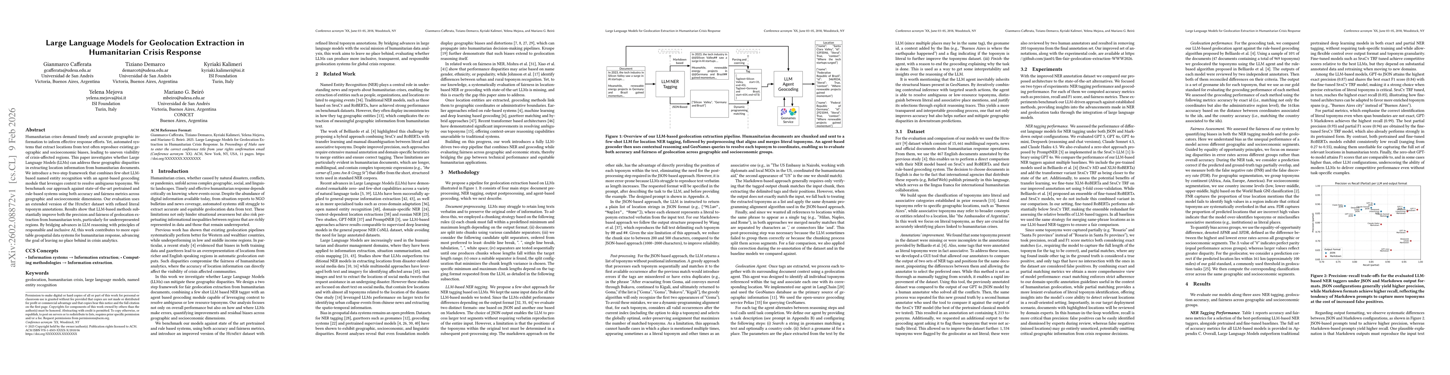
Key Findings, in focus
Seven facets of this paper, analysed and brought into focus by AI.
The study shows that LLMs can deliver more accurate and equitable geolocation extraction for humanitarian texts, enabling responders to access reliable spatial information from under‑represented regions and advancing the goal of leaving no place behind
- LLM-based NER (GPT‑4oJSON) achieves the highest exact precision (0.87) and F1 (0.84) while maintaining near‑parity in false‑negative rates across continents and income groups
- The agent-based geocoder outperforms the rule‑based baseline on exact, 161 km, and country‑level metrics, reducing classification error by up to 50 % in high‑income regions
- Both components together substantially improve precision, recall, and fairness compared to pretrained and fine‑tuned transformer baselines, demonstrating that minimal annotation is sufficient for high‑quality extraction
The study shows that LLMs can deliver more accurate and equitable geolocation extraction for humanitarian texts, enabling responders to access reliable spatial information from under‑represented regions and advancing the goal of leaving no place behind
Integration of few‑shot LLM NER with an agent‑based geocoder that leverages contextual reasoning and explicit selection traces, enabling transparent and accurate toponym resolution
First to combine LLM-driven NER with an agent‑based geocoder for humanitarian crisis texts, achieving fairness gains and minimal annotation effort compared to traditional rule‑based and fine‑tuned transformer approaches
- Residual geographic and socioeconomic bias remains, particularly in high‑income regions where false‑discovery rates are higher
- The evaluation is limited to English documents, restricting generalizability to multilingual humanitarian reports
- Investigate supervised prompt optimization and multilingual adaptation to further reduce bias and improve zero‑shot performance
- Integrate additional diverse data sources and continuous algorithmic auditing to monitor and mitigate emerging biases
Discussion 0