ArxivLens
ArXiv cs.RO

Large-Scale Tunnel Air--Ground Collaboration With FLISP: Fast LiDAR-IMU Synchronized Path Planne

Fenghe Guo, Runjie Shen, Chenyang Sun, Junrui Zhang, Quanxi Zhan, Yongchun Wang, Junjie Zhang

2606.25393 IEEE Transactions on Field Robotics, vol. 3, pp. 494-517, 2026 DOI: 10.1109/TFR.2026.3697669 Published Jun 24, 2026
View PDF

Publication

Published: Jun 24, 2026
Categories: cs.RO

Metrics

Source: ArXiv

Quick Answers

What methodology did the authors use?

FLISP leverages a mapless, UGV-centric architecture that uses a single ground vehicle LiDAR-IMU sensor suite to generate synchronized, collision-free trajectories for both UGV and UAV. It employs platform-specific solvers (enhanced Firefly Algorithm for UGV obstacle avoidance and a dynamic iterative optimizer for UAV flight) within a hierarchical refinement framework to ensure kinematic feasibility without state estimation drift, enabling real-time path... More in Methodology →

What are the key results?

Achieved 100% planning and execution success in the tested tunnel scenarios with approximately 7 ms end-to-end latency. — Demonstrated a sevenfold speedup over grid-based methods and orders of magnitude improvement over sampling-based baselines. More in Key Results →

Why is this work significant?

The mapless, UG V–driven collaboration framework provides a scalable, drift-free, real-time solution for inspection of feature-degraded linear infrastructure, addressing long-standing challenges in GPS-denied tunnel environments and reducing computational load relative to map-based paradigms. More in Significance →

What are the main limitations?

Benchmarking is focused on a 1.2 km hydropower tunnel; performance in substantially longer or more structurally complex tunnels remains unverified. — Reliance on a single LiDAR-IMU suite may pose sensitivity to sensor failure or calibration drift over extended deployments. More in Limitations →

Paper Preview

Abstract

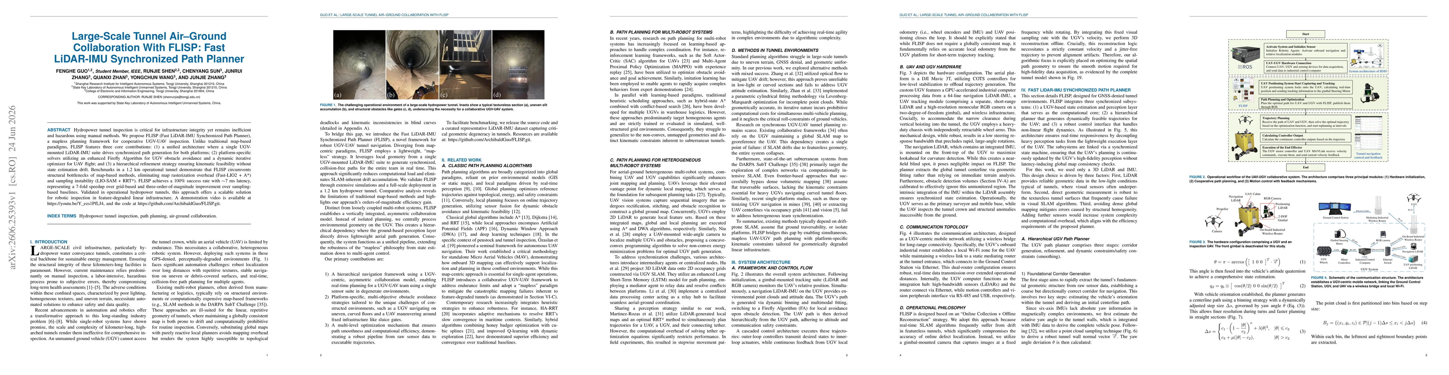
Hydropower tunnel inspection is critical for infrastructure integrity yet remains inefficient and hazardous using manual methods. We propose FLISP (Fast LiDAR-IMU Synchronized Path Planner), a mapless planning framework for cooperative UGV-UAV inspection. Unlike traditional map-based paradigms, FLISP features three core contributions: (1) a unified architecture where a single UGV-mounted LiDAR-IMU suite drives synchronized path generation for both platforms; (2) platform-specific solvers utilizing an enhanced Firefly Algorithm for UGV obstacle avoidance and a dynamic iterative optimizer for UAV flight; and (3) a hierarchical refinement strategy ensuring kinematic feasibility without state estimation drift. Benchmarks in a 1.2 km operational tunnel demonstrate that FLISP circumvents structural bottlenecks of map-based methods, eliminating map rasterization overhead (Fast-LIO2 + A*) and sampling instability (LIO-SAM + RRT*). FLISP achieves a 100% success rate with ~7 ms latency, representing a 7-fold speedup over grid-based and three-order-of-magnitude improvement over sampling-based baselines. Validated in operational hydropower tunnels, this approach offers a scalable solution for robotic inspection in feature-degraded linear infrastructure. A demonstration video is available at https://youtu.be/Y_ezs1PfLJ4, and the code at https://github.com/ArchibaldGuo/FLISP.git.

Key Findings, in focus

Seven facets of this paper, analysed and brought into focus by AI.

AI-generated · verify against source Generated Jun 26, 2026
In focus · one-line synthesis

The mapless, UG V–driven collaboration framework provides a scalable, drift-free, real-time solution for inspection of feature-degraded linear infrastructure, addressing long-standing challenges in GPS-denied tunnel environments and reducing computational load relative to map-based paradigms.

01
MethodologyHow they did it

FLISP leverages a mapless, UGV-centric architecture that uses a single ground vehicle LiDAR-IMU sensor suite to generate synchronized, collision-free trajectories for both UGV and UAV. It employs platform-specific solvers (enhanced Firefly Algorithm for UGV obstacle avoidance and a dynamic iterative optimizer for UAV flight) within a hierarchical refinement framework to ensure kinematic feasibility without state estimation drift, enabling real-time path generation in 1.2 km tunnel benchmarks.

02
ResultsWhat they found
  • Achieved 100% planning and execution success in the tested tunnel scenarios with approximately 7 ms end-to-end latency.
  • Demonstrated a sevenfold speedup over grid-based methods and orders of magnitude improvement over sampling-based baselines.
  • Eliminated map rasterization overhead and sampling instability associated with traditional SLAM-based approaches.
03
SignificanceWhy it matters

The mapless, UG V–driven collaboration framework provides a scalable, drift-free, real-time solution for inspection of feature-degraded linear infrastructure, addressing long-standing challenges in GPS-denied tunnel environments and reducing computational load relative to map-based paradigms.

04
Technical ContributionsWhat's new technically

Introduction of FLISP, a unified mapless framework enabling asymmetric, ground-robot–driven collaboration for UGV-UAV tunnel inspection, with platform-specific solvers and a hierarchical refinement strategy to ensure real-time, feasible trajectories without state estimation drift.

05
NoveltyWhat sets it apart

First work to present a vertically integrated, mapless UGV-centric collaboration model that drives synchronized multi-robot paths for both ground and aerial platforms from a single LiDAR-IMU suite, eliminating traditional map-based bottlenecks while maintaining kinematic feasibility.

06
LimitationsWhat to be cautious about
  • Benchmarking is focused on a 1.2 km hydropower tunnel; performance in substantially longer or more structurally complex tunnels remains unverified.
  • Reliance on a single LiDAR-IMU suite may pose sensitivity to sensor failure or calibration drift over extended deployments.
  • The hierarchical refinement pipeline may introduce conservatism in highly dynamic or rapidly changing obstacle configurations.
07
Future WorkWhere it goes next
  • Extend evaluation to longer tunnel sections and diverse geometric features to validate scalability.
  • Investigate sensor fault-tolerant strategies and multi-sensor redundancy to enhance robustness.
  • Develop adaptive parameter tuning for the Firefly-based UGV solver and UAV optimizer to handle varying environmental conditions.

Paper Details

Paper ID: 2606.25393
Journal: IEEE Transactions on Field Robotics, vol. 3, pp. 494-517, 2026
Comments: 24 pages, 31 figures, 5 tables. Author accepted manuscript. This work was supported by the State Key Laboratory of Autonomous Intelligent Unmanned Systems. The authors also thank the KinaMind Society for its inspiring environment and support
Categories:
cs.RO

How to Cite This Paper

Reference manager: RIS EndNote


Discussion 0

This website uses cookies to ensure you get the best experience. Learn more