ArxivLens

Quick Summary:

This paper proposes a multi-scale deep learning method for high-resolution satellite image classification using spatial pyramid pooling networks to efficiently train multiple networks. It combines multi-scale features through multiple kernel learning for optimal classification performance.

arXiv Id: 1611.03591
Date Published: 2016-11-14
Date Updated: 2016-11-14

Categories:

Key Terms (TF-IDF):

multi scale (0.260)
satellite (0.235)
nets (0.223)
deep (0.161)
scale (0.158)
multiple (0.153)
multi (0.150)
images (0.137)
image (0.134)
training (0.129)
method achieves (0.125)
image classification (0.124)
compared state (0.124)
performance compared (0.123)
favorable (0.123)
accelerating (0.123)
address issue (0.122)
features (0.122)
ensures (0.118)
art methods (0.117)
License: http://arxiv.org/licenses/nonexclusive-distrib/1.0/

Summary:

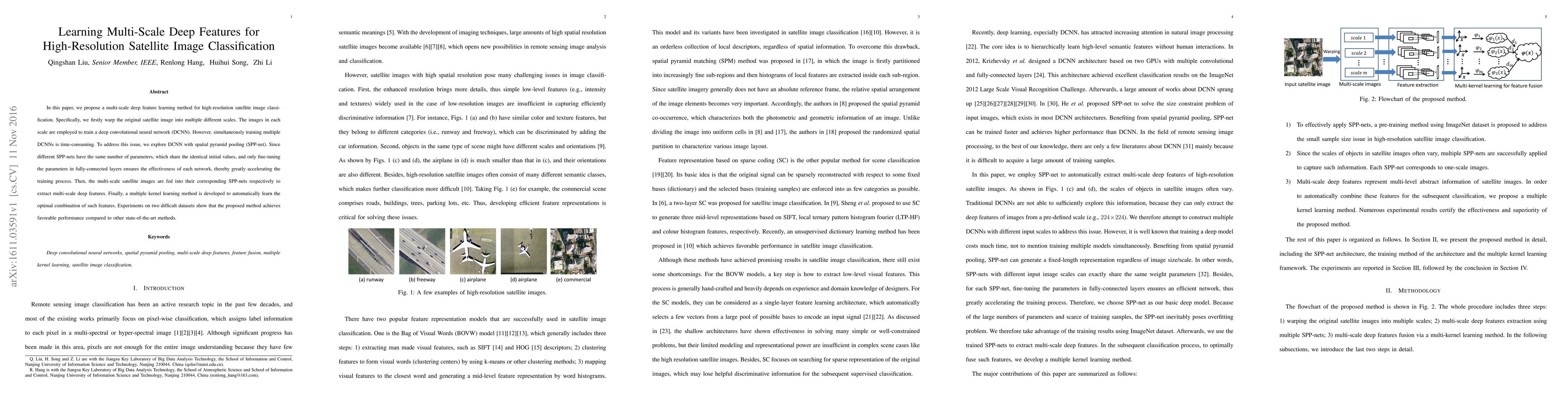
In this paper, we propose a multi-scale deep feature learning method for high-resolution satellite image classification. Specifically, we firstly warp the original satellite image into multiple different scales. The images in each scale are employed to train a deep convolutional neural network (DCNN). However, simultaneously training multiple DCNNs is time-consuming. To address this issue, we explore DCNN with spatial pyramid pooling (SPP-net). Since different SPP-nets have the same number of parameters, which share the identical initial values, and only fine-tuning the parameters in fully-connected layers ensures the effectiveness of each network, thereby greatly accelerating the training process. Then, the multi-scale satellite images are fed into their corresponding SPP-nets respectively to extract multi-scale deep features. Finally, a multiple kernel learning method is developed to automatically learn the optimal combination of such features. Experiments on two difficult datasets show that the proposed method achieves favorable performance compared to other state-of-the-art methods.

Citation & Reference Network Visualization

This graph shows how this paper is connected to other research. The current paper is shown in dark gray, papers that cite it are in green, and papers it references are in blue. You can:

Current Paper
Papers citing this work (Citations)
Papers cited by this work (References)

• Hover over any node to see the paper title

• Click a node to view that paper's details

• Drag nodes to rearrange the graph

• Use the zoom controls (bottom right) to zoom in/out

Citations and References

Title Authors Year Actions
Depthwise Separable Residual Network for Remote Sensing Image Scene Classification
Huanhuan Lv, Guofeng Peng, Zhang Hui
2022
View Paper
Semi-Supervised DEGAN for Optical High-Resolution Remote Sensing Image Scene Classification
Jia Li, Yujia Liao, Junjie Zhang, Dan Zeng, Xiaoliang Qian
2022
View Paper
Extraction and Classification of the Supervised Coastal Objects Based on HSRIs and a Novel Lightweight Fully Connected Spatial Dropout Network
Yan Chen, Jiahua Wan, Yantao Xi, Wenxiang Jiang, Mengyuan Wang, Menglei Kang
2022
View Paper
Multiscale U-Shaped CNN Building Instance Extraction Framework With Edge Constraint for High-Spatial-Resolution Remote Sensing Imagery
Yuanyuan Liu, Dingyuan Chen, A. Ma, Yanfei Zhong, Fang Fang, Kai Xu
2021
View Paper
A Lightweight and Robust Lie Group-Convolutional Neural Networks Joint Representation for Remote Sensing Scene Classification
Chengjun Xu, G. Zhu, Jin Shu
2021
View Paper
Gaussian RAM: Lightweight Image Classification via Stochastic Retina-Inspired Glimpse and Reinforcement Learning
D. Shim, H. Kim
2020
View Paper
Towards Generating the Habitat Maps for UAE using a Transfer Learning Approach
Prajowal Manandhar, Khaled Al Hashmi, P. Marpu, Fatima Alaydaroos
2020
View Paper
TransLand: An Adversarial Transfer Learning Approach for Migratable Urban Land Usage Classification using Remote Sensing
Yang Zhang, Ruohan Zong, Jun Han, Hao Zheng, Qiuwen Lou, D. Zhang, Dong Wang
2019
View Paper
BoVSG: bag of visual SubGraphs for remote sensing scene classification
K. Amiri, Mohamed Farah, U. Leloğlu
2019
View Paper
Aggregated Deep Fisher Feature for VHR Remote Sensing Scene Classification
Boyang Li, Weihua Su, Hang Wu, Ruihao Li, Wenchang Zhang, Wei Qin, Shiyue Zhang
2019
View Paper
Multi-model fusion based satellite image classification using versatile unsupervised vector zone (VUVZ) fusion and intensive pragmatic blossoms (IPB) technique
R. Swathika, T. S. Sharmila
2019
View Paper
Change Detection and Transfer Learning Approach for Updating the Habitat Maps in UAE
Prajowal Manandhar, P. Marpu
2019
View Paper
Joint Learning of the Center Points and Deep Metrics for Land-Use Classification in Remote Sensing
Z. Gong, P. Zhong, Weidong Hu, Yuming Hua
2019
View Paper
An Ensemble Approach to Transfer Learning for Classification of Habitat Mapping
Prajowal Manandhar, P. Marpu, Z. Aung
2018
View Paper
Learning Discriminative 3D Shape Representations by View Discerning Networks
B. Leng, Cheng Zhang, Xiaochen Zhou, Cheng Xu, Kai Xu
2018
View Paper
Beyond RGB: Very High Resolution Urban Remote Sensing With Multimodal Deep Networks
N. Audebert, B. L. Saux, S. Lefèvre
2017
View Paper
On the Selective and Invariant Representation of DCNN for High-Resolution Remote Sensing Image Recognition
Jie Chen, Chao Yuan, M. Deng, Chao Tao, Jian Peng, Haifeng Li
2017
View Paper
Image representation alternatives for the analysis of satellite image time series
C. Dumitru, G. Schwarz, M. Datcu
2017
View Paper
Scene Classification Based on Multiscale Convolutional Neural Network
Yanfei Liu, Yanfei Zhong, Q. Qin
2017
View Paper
Using Convolutional Networks and Satellite Imagery to Identify Patterns in Urban Environments at a Large Scale
A. Albert, Jasleen Kaur, Marta C. González
2017
View Paper
Bidirectional-Convolutional LSTM Based Spectral-Spatial Feature Learning for Hyperspectral Image Classification
Qingshan Liu, F. Zhou, Renlong Hang, Xiaotong Yuan
2017
View Paper
THE SPATIAL INDUCTIVE BIAS OF DEEP LEARNING
B. Mitchell
2017
View Paper
Origin-destination trips by purpose and time of day inferred from mobile phone data
Lauren P. Alexander, Shan Jiang, M. Murga, Marta C. González
2015
View Paper
Domain Adaptation via a Task-Specific Classifier Framework for Remote Sensing Cross-Scene Classification
Zhendong Zheng, Yanfei Zhong, Yuxuan Su, A. Ma
2022
View Paper
SEMSDNet: A Multiscale Dense Network With Attention for Remote Sensing Scene Classification
Tian Tian, Lingling Li, Weitao Chen, Huabing Zhou
2021
View Paper
Predicting Ground-Level Ozone Concentration from Urban Satellite and Street-Level Imagery using Multimodal CNN
Andrea Vallebueno, Nina Prakash, Nicolas Suarez
2021
View Paper
An Efficient Convolutional Neural Network for Remote-Sensing Scene Image Classification
Muhammad Ashad Baloch, Sajid Ali, Mubashir H. Malik, Aamir Hussain, Abdul Mustaan Madni
2020
View Paper
Shallow–Deep Convolutional Network and Spectral-Discrimination-Based Detail Injection for Multispectral Imagery Pan-Sharpening
Lu Liu, Jun Wang, Erlei Zhang, Bin Li, Xuan Zhu, Yongqin Zhang, Jinye Peng
2020
View Paper
Amazon Rainforest Satellite Image Labelling Challenge
Yixin Cai
2017
View Paper
Final Report Deep Multi-Label Classification for High Resolution Satellite Imagery of Rainforests
Robert Sun, Christian Castellanos, Andrew Nguyen
2017
View Paper

Comments (0)

This website uses cookies to ensure you get the best experience. Learn more