Quick Summary:

This paper proposes a two-stage framework to enhance OSM-guided autonomous navigation by learning an Orientation Field (OrField) from LiDAR scans and OSM routes, addressing inaccuracies due to noisy data. The framework uses a deep neural network to optimize OrField, which informs two trajectory planners, Field-RRT* and Field-Bezier, to generate accurate trajectories even in complex scenarios. Experiments on SemanticKITTI and a campus dataset show superior performance in challenging conditions.

Summary

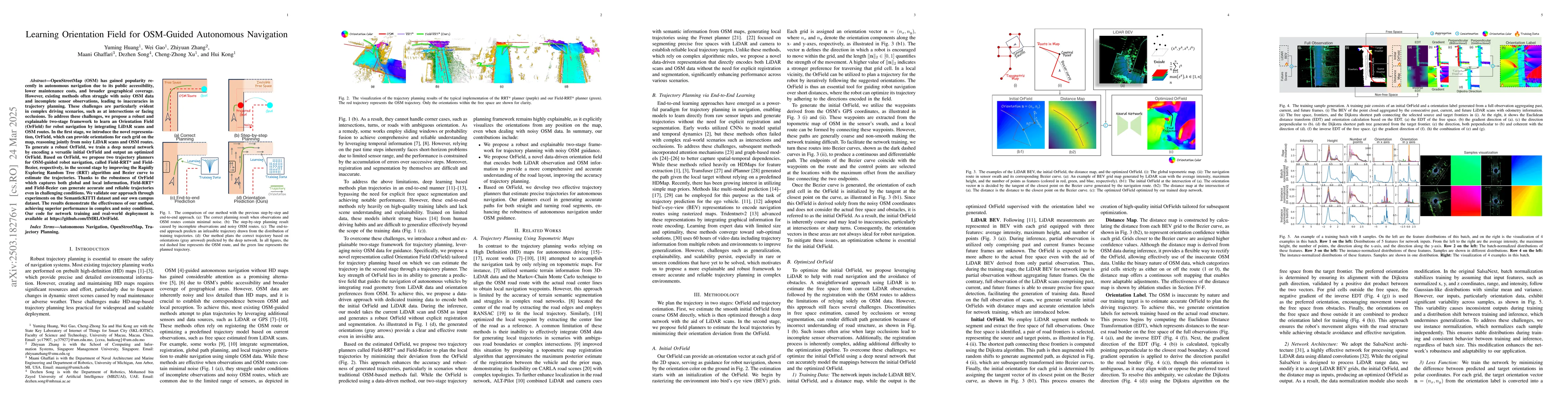
OpenStreetMap (OSM) has gained popularity recently in autonomous navigation due to its public accessibility, lower maintenance costs, and broader geographical coverage. However, existing methods often struggle with noisy OSM data and incomplete sensor observations, leading to inaccuracies in trajectory planning. These challenges are particularly evident in complex driving scenarios, such as at intersections or facing occlusions. To address these challenges, we propose a robust and explainable two-stage framework to learn an Orientation Field (OrField) for robot navigation by integrating LiDAR scans and OSM routes. In the first stage, we introduce the novel representation, OrField, which can provide orientations for each grid on the map, reasoning jointly from noisy LiDAR scans and OSM routes. To generate a robust OrField, we train a deep neural network by encoding a versatile initial OrField and output an optimized OrField. Based on OrField, we propose two trajectory planners for OSM-guided robot navigation, called Field-RRT* and Field-Bezier, respectively, in the second stage by improving the Rapidly Exploring Random Tree (RRT) algorithm and Bezier curve to estimate the trajectories. Thanks to the robustness of OrField which captures both global and local information, Field-RRT* and Field-Bezier can generate accurate and reliable trajectories even in challenging conditions. We validate our approach through experiments on the SemanticKITTI dataset and our own campus dataset. The results demonstrate the effectiveness of our method, achieving superior performance in complex and noisy conditions. Our code for network training and real-world deployment is available at https://github.com/IMRL/OriField.

AI Key Findings

Generated Jun 10, 2025

Methodology

The research proposes a two-stage framework to learn an Orientation Field (OrField) for robot navigation, integrating LiDAR scans and OSM routes. It introduces a deep neural network to optimize an initial OrField, generating a robust OrField. Trajectory planners, Field-RRT* and Field-Bezier, are then proposed based on OrField for OSM-guided robot navigation.

Key Results

  • The proposed method generates accurate and reliable trajectories even in challenging conditions, such as intersections or occlusions.
  • Experiments on SemanticKITTI and campus datasets demonstrate superior performance in complex and noisy conditions compared to existing methods.
  • Field-RRT* and Field-Bezier outperform other methods in most sequences on SemanticKITTI dataset.
  • The method shows robustness to low-density data and short sensor range, as evidenced by results on the campus dataset.
  • Ablation studies confirm the effectiveness of the deep network in optimizing OrField and the superiority of the field planner over the point planner.

Significance

This research is significant as it addresses the challenges of noisy OSM data and incomplete sensor observations in autonomous navigation, providing a robust and explainable solution with potential for real-world applications.

Technical Contribution

The paper presents a novel Orientation Field representation for robot navigation, a deep learning network for optimizing OrField, and two trajectory planners (Field-RRT* and Field-Bezier) that leverage OrField for accurate and reliable path planning.

Novelty

The approach differs from existing methods by jointly reasoning from noisy LiDAR scans and OSM routes to learn a robust Orientation Field, which captures both global and local navigation information.

Limitations

  • The method relies on LiDAR scans and OSM routes, which may not be available or accurate in all environments.
  • Performance may vary with the quality and coverage of OSM data in different regions.

Future Work

  • Explore integration with other sensor modalities for improved robustness.
  • Investigate applicability in diverse environments and dynamic scenarios.

Paper Details

PDF Preview

Download PDF

Key Terms

No key terms available for this paper.

Citation Network

Current paper (gray), citations (green), references (blue)

Current Paper
Citations
References
Click to view

No citations found for this paper.

Comments (0)

This website uses cookies to ensure you get the best experience. Learn more