Summary

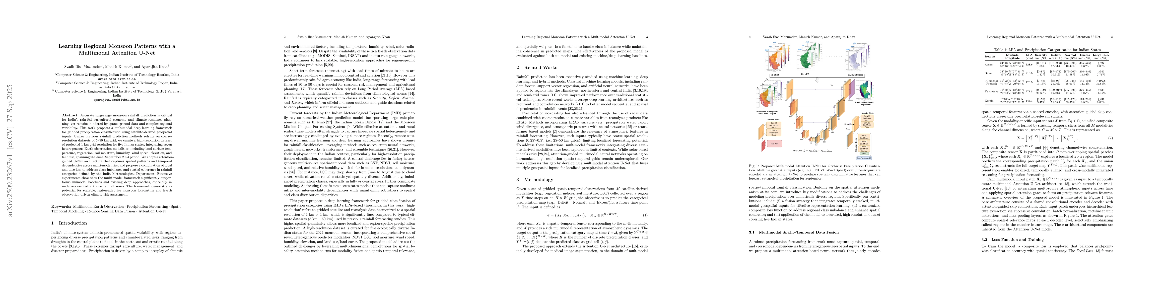
Accurate monsoon rainfall prediction is vital for India's agriculture, water management, and climate risk planning, yet remains challenging due to sparse ground observations and complex regional variability. We present a multimodal deep learning framework for high-resolution precipitation classification that leverages satellite and Earth observation data. Unlike previous rainfall prediction models based on coarse 5-50 km grids, we curate a new 1 km resolution dataset for five Indian states, integrating seven key geospatial modalities: land surface temperature, vegetation (NDVI), soil moisture, relative humidity, wind speed, elevation, and land use, covering the June-September 2024 monsoon season. Our approach uses an attention-guided U-Net architecture to capture spatial patterns and temporal dependencies across modalities, combined with focal and dice loss functions to handle rainfall class imbalance defined by the India Meteorological Department (IMD). Experiments demonstrate that our multimodal framework consistently outperforms unimodal baselines and existing deep learning methods, especially in extreme rainfall categories. This work contributes a scalable framework, benchmark dataset, and state-of-the-art results for regional monsoon forecasting, climate resilience, and geospatial AI applications in India.

AI Key Findings

Generated Oct 01, 2025

Methodology

The research employs a multimodal deep learning framework combining an attention-enhanced U-Net architecture with joint optimization of focal and Dice losses. It integrates heterogeneous satellite-derived geospatial inputs to capture spatio-temporal patterns for high-resolution precipitation forecasting.

Key Results

  • The model outperforms existing methods including XGBoost, ViT, and ResNet18 across five Indian states in both overall accuracy and weighted F1 score
  • It achieves perfect scores (1.0000) for the Large Excess class in Assam, demonstrating improved performance for rare precipitation categories
  • The attention-based spatio-temporal fusion enables sharper spatial transitions and better regional rainfall pattern capture

Significance

This research provides a robust solution for regional precipitation forecasting, enhancing disaster preparedness and water resource management through accurate localized weather predictions.

Technical Contribution

Development of a composite loss function combining focal loss for class imbalance and Dice loss for spatial consistency, integrated within an attention-enhanced U-Net architecture for multi-source geospatial data fusion.

Novelty

The work introduces a novel attention-based spatio-temporal fusion approach for multi-source geophysical inputs, enabling high-resolution localized precipitation forecasting that outperforms both traditional and deep learning baselines.

Limitations

  • The model's performance may degrade in regions with extremely diverse topography not well-represented in training data
  • The framework requires substantial computational resources for training and inference

Future Work

  • Exploring extensions to nowcasting settings and continuous precipitation estimation
  • Enhancing scalability for pan-India and cross-national datasets
  • Integrating additional geophysical data sources for improved predictions

Paper Details

PDF Preview

Download PDF

Comments (0)

This website uses cookies to ensure you get the best experience. Learn more