Learning to Estimate Two Dense Depths from LiDAR and Event Data
Publication
Metrics
AI Quick Summary
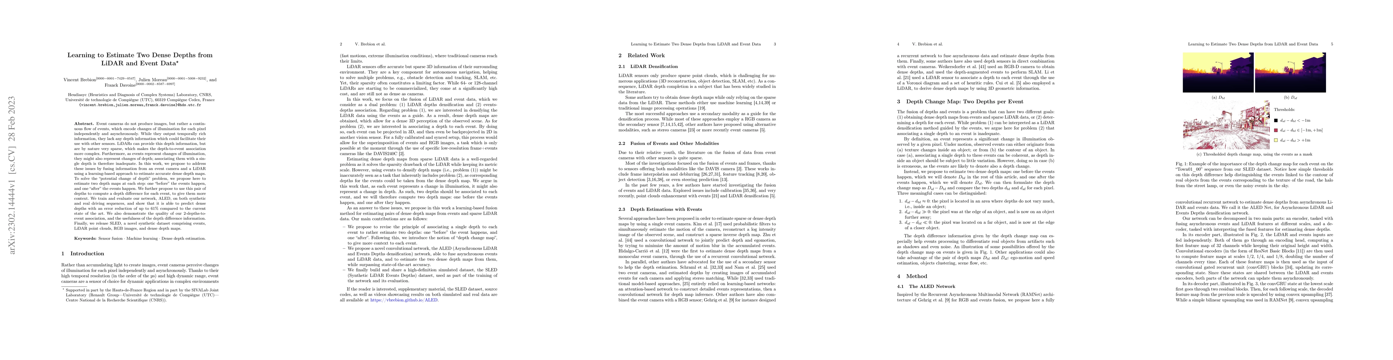
This paper proposes a learning-based approach, ALED, to fuse event camera and LiDAR data for estimating dense depth maps by generating two depth maps per event: one before and one after the event. The method achieves a 61% error reduction compared to current state-of-the-art techniques and introduces a new synthetic dataset, SLED, for training and evaluation.
Paper Preview
Abstract
Event cameras do not produce images, but rather a continuous flow of events, which encode changes of illumination for each pixel independently and asynchronously. While they output temporally rich information, they lack any depth information which could facilitate their use with other sensors. LiDARs can provide this depth information, but are by nature very sparse, which makes the depth-to-event association more complex. Furthermore, as events represent changes of illumination, they might also represent changes of depth; associating them with a single depth is therefore inadequate. In this work, we propose to address these issues by fusing information from an event camera and a LiDAR using a learning-based approach to estimate accurate dense depth maps. To solve the "potential change of depth" problem, we propose here to estimate two depth maps at each step: one "before" the events happen, and one "after" the events happen. We further propose to use this pair of depths to compute a depth difference for each event, to give them more context. We train and evaluate our network, ALED, on both synthetic and real driving sequences, and show that it is able to predict dense depths with an error reduction of up to 61% compared to the current state of the art. We also demonstrate the quality of our 2-depths-to-event association, and the usefulness of the depth difference information. Finally, we release SLED, a novel synthetic dataset comprising events, LiDAR point clouds, RGB images, and dense depth maps.
AI Key Findings
Get AI-generated insights about this paper's methodology, results, significance, and more — seven facets brought into focus.
Impact
Paper Details
Authors
PDF Preview
Key Terms
Citation Network
Current paper (gray), citations (green), references (blue)
Display is limited for performance on very large graphs.
Discussion 0