Lessons Learned Report: Super-Resolution for Detection Tasks in Engineering Problem-Solving
Publication
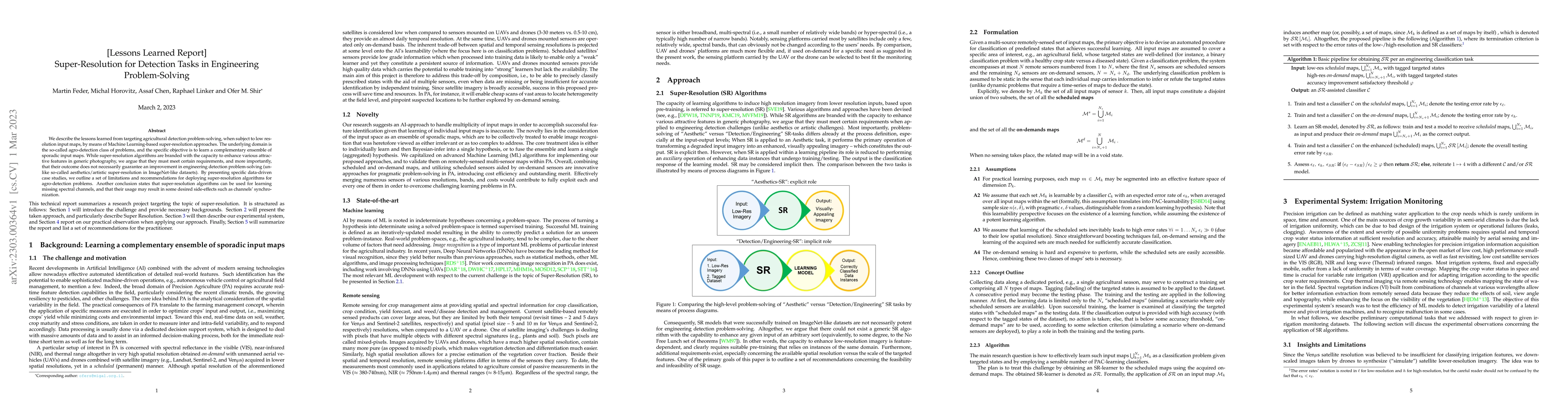
Metrics
AI Quick Summary
This paper examines the application of machine learning-based super-resolution techniques to enhance agricultural detection tasks from low-resolution input maps. It highlights limitations and provides recommendations for effective deployment, noting that while super-resolution can improve feature enhancement, it does not always improve detection outcomes in engineering problems.
Paper Preview
Abstract
We describe the lessons learned from targeting agricultural detection problem-solving, when subject to low resolution input maps, by means of Machine Learning-based super-resolution approaches. The underlying domain is the so-called agro-detection class of problems, and the specific objective is to learn a complementary ensemble of sporadic input maps. While super-resolution algorithms are branded with the capacity to enhance various attractive features in generic photography, we argue that they must meet certain requirements, and more importantly, that their outcome does not necessarily guarantee an improvement in engineering detection problem-solving (unlike so-called aesthetics/artistic super-resolution in ImageNet-like datasets). By presenting specific data-driven case studies, we outline a set of limitations and recommendations for deploying super-resolution algorithms for agro-detection problems. Another conclusion states that super-resolution algorithms can be used for learning missing spectral channels, and that their usage may result in some desired side-effects such as channels' synchronization.
AI Key Findings
Get AI-generated insights about this paper's methodology, results, significance, and more — seven facets brought into focus.
Impact
Paper Details
Authors
PDF Preview
Key Terms
Citation Network
Current paper (gray), citations (green), references (blue)
Display is limited for performance on very large graphs.
Discussion 0