Leveraging Self-Supervised Features for Efficient Flooded Region Identification in UAV Aerial Images
Publication
Metrics
Paper Preview
Abstract
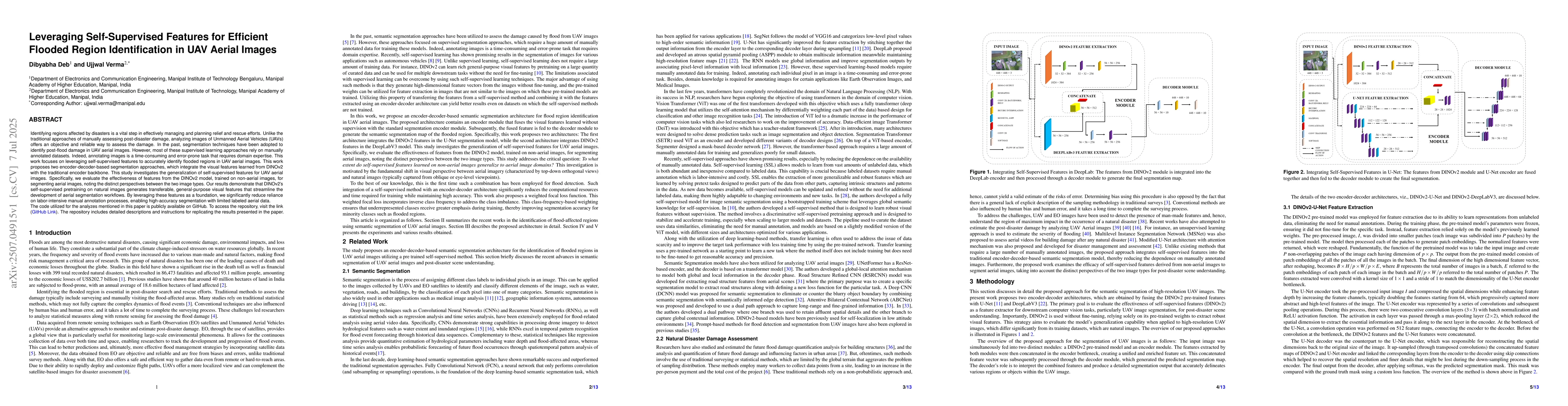
Identifying regions affected by disasters is a vital step in effectively managing and planning relief and rescue efforts. Unlike the traditional approaches of manually assessing post-disaster damage, analyzing images of Unmanned Aerial Vehicles (UAVs) offers an objective and reliable way to assess the damage. In the past, segmentation techniques have been adopted to identify post-flood damage in UAV aerial images. However, most of these supervised learning approaches rely on manually annotated datasets. Indeed, annotating images is a time-consuming and error-prone task that requires domain expertise. This work focuses on leveraging self-supervised features to accurately identify flooded regions in UAV aerial images. This work proposes two encoder-decoder-based segmentation approaches, which integrate the visual features learned from DINOv2 with the traditional encoder backbone. This study investigates the generalization of self-supervised features for UAV aerial images. Specifically, we evaluate the effectiveness of features from the DINOv2 model, trained on non-aerial images, for segmenting aerial images, noting the distinct perspectives between the two image types. Our results demonstrate that DINOv2's self-supervised pretraining on natural images generates transferable, general-purpose visual features that streamline the development of aerial segmentation workflows. By leveraging these features as a foundation, we significantly reduce reliance on labor-intensive manual annotation processes, enabling high-accuracy segmentation with limited labeled aerial data.
AI Key Findings
Get AI-generated insights about this paper's methodology, results, significance, and more — seven facets brought into focus.
Impact
Paper Details
Authors
PDF Preview
Citation Network
Current paper (gray), citations (green), references (blue)
Display is limited for performance on very large graphs.
Discussion 0