Quick Summary:

This paper introduces HDMapLaneNet, a framework using V2X communication and Scene Graph Generation to collaboratively build localized HD maps, extracting lane centerlines from camera images and transmitting them for cloud aggregation, showing improved performance on the nuScenes dataset.

Summary

High-Definition (HD) maps play a crucial role in autonomous vehicle navigation, complementing onboard perception sensors for improved accuracy and safety. Traditional HD map generation relies on dedicated mapping vehicles, which are costly and fail to capture real-time infrastructure changes. This paper presents HDMapLaneNet, a novel framework leveraging V2X communication and Scene Graph Generation to collaboratively construct a localized geometric layer of HD maps. The approach extracts lane centerlines from front-facing camera images, represents them as graphs, and transmits the data for global aggregation to the cloud via V2X. Preliminary results on the nuScenes dataset demonstrate superior association prediction performance compared to a state-of-the-art method.

AI Key Findings

Generated Jun 11, 2025

Methodology

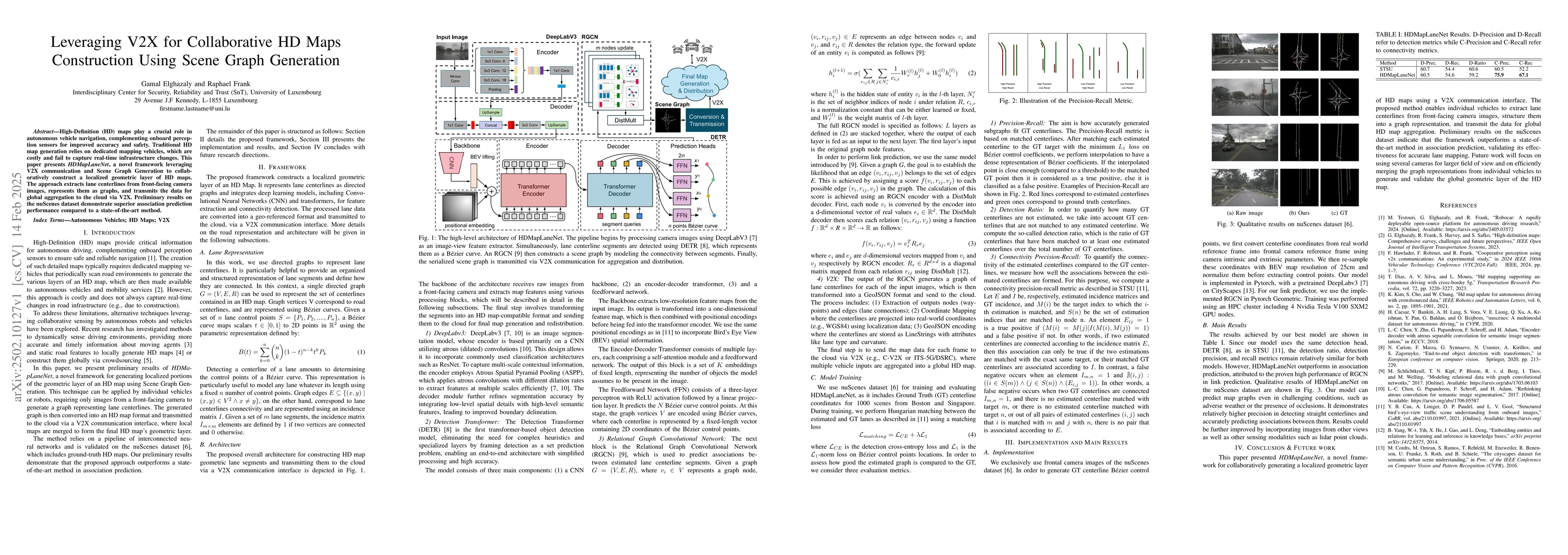
The paper introduces HDMapLaneNet, a framework leveraging V2X communication and Scene Graph Generation for collaborative HD map construction. It uses front-facing camera images, DeepLabV3 for feature extraction, DETR for lane centerline detection, and RGCN for predicting associations between segments.

Key Results

  • HDMapLaneNet outperforms a state-of-the-art method in association prediction on the nuScenes dataset.
  • The model can predict map graphs even in challenging conditions like adverse weather or occlusions.

Significance

This research is significant as it enables individual vehicles to extract, structure, and transmit lane centerlines for global HD map aggregation, enhancing autonomous vehicle navigation accuracy and safety.

Technical Contribution

The main technical contribution is HDMapLaneNet, a novel framework that combines V2X communication, scene graph generation, and RGCN for collaborative HD map construction.

Novelty

This work is novel in its approach to using V2X for collaborative HD map construction and its application of RGCN for link prediction in the context of lane centerline association.

Limitations

  • The current implementation relies solely on frontal camera images, which may limit field of view and performance in certain conditions.
  • The model's performance could potentially be improved by incorporating data from other sensing modalities like LiDAR.

Future Work

  • Expanding the model to use multiple camera views for a larger field of view.
  • Integrating other sensing modalities such as LiDAR point clouds for more comprehensive data collection.

Paper Details

PDF Preview

Download PDF

Key Terms

No key terms available for this paper.

Citation Network

Current paper (gray), citations (green), references (blue)

Current Paper
Citations
References
Click to view

No citations found for this paper.

Comments (0)

This website uses cookies to ensure you get the best experience. Learn more