ArxivLens

Quick Summary:

This paper proposes a lightweight temporal self-attention method for classifying satellite image time series, utilizing parallel compact attention heads to extract specialized temporal features. The approach achieves superior performance compared to other algorithms with fewer parameters and lower computational complexity.

arXiv Id: 2007.00586
Date Published: 2020-07-09
Date Updated: 2020-07-09

Categories:

Key Terms (TF-IDF):

temporal (0.231)
satellite (0.226)
time series (0.215)
attention (0.213)
series (0.169)
remote sensing (0.159)
head (0.147)
calls (0.146)
recent work (0.140)
outperforms state (0.140)
industrial (0.139)
classify (0.138)
fewer (0.138)
remote (0.136)
computational complexity (0.133)
opportunities (0.132)
considerable (0.132)
encoder (0.131)
earth (0.127)
inputs (0.126)
License: http://arxiv.org/licenses/nonexclusive-distrib/1.0/

Summary:

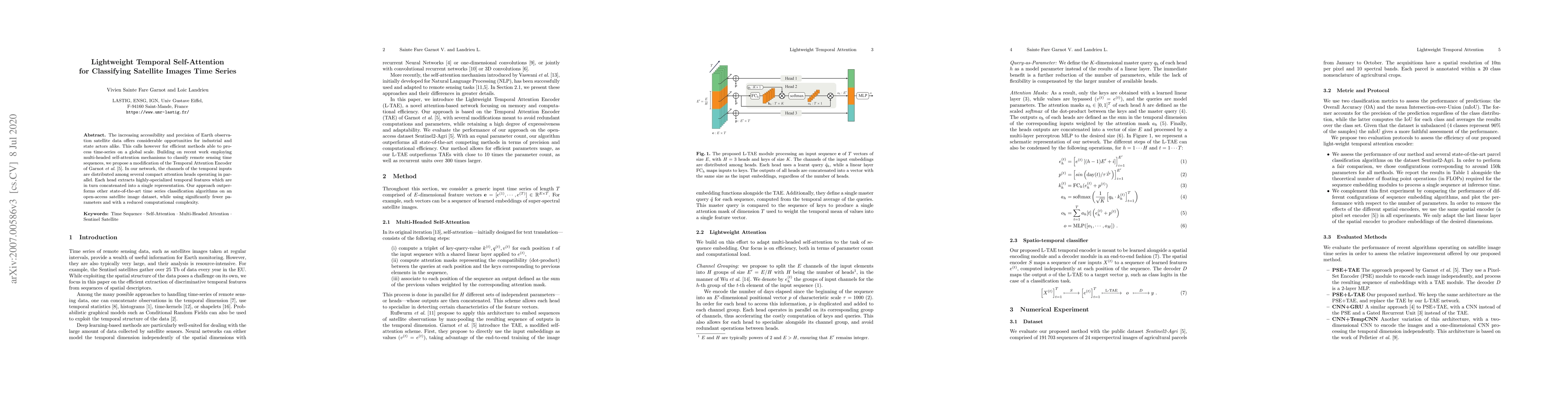
The increasing accessibility and precision of Earth observation satellite data offers considerable opportunities for industrial and state actors alike. This calls however for efficient methods able to process time-series on a global scale. Building on recent work employing multi-headed self-attention mechanisms to classify remote sensing time sequences, we propose a modification of the Temporal Attention Encoder. In our network, the channels of the temporal inputs are distributed among several compact attention heads operating in parallel. Each head extracts highly-specialized temporal features which are in turn concatenated into a single representation. Our approach outperforms other state-of-the-art time series classification algorithms on an open-access satellite image dataset, while using significantly fewer parameters and with a reduced computational complexity.

Citation & Reference Network Visualization

This graph shows how this paper is connected to other research. The current paper is shown in dark gray, papers that cite it are in green, and papers it references are in blue. You can:

Current Paper
Papers citing this work (Citations)
Papers cited by this work (References)

• Hover over any node to see the paper title

• Click a node to view that paper's details

• Drag nodes to rearrange the graph

• Use the zoom controls (bottom right) to zoom in/out

Citations and References

Title Authors Year Actions
How high are we? Large-scale building height estimation at 10 m using Sentinel-1 SAR and Sentinel-2 MSI time series
Ritu Yadav, A. Nascetti, Yifang Ban
2025
View Paper
FireCastNet: Earth-as-a-Graph for Seasonal Fire Prediction
Dimitrios Michail, Charalampos Davalas, Lefki-Ioanna Panagiotou, Ioannis Prapas, Spyros Kondylatos, N. Bountos, Ioannis Papoutsis
2025
View Paper
A dual-branch network for crop-type mapping of scattered small agricultural fields in time series remote sensing images
Yanjun Wu, Zhenyue Peng, Yimin Hu, Rujing Wang, Taosheng Xu
2025
View Paper
AnySat: An Earth Observation Model for Any Resolutions, Scales, and Modalities
Guillaume Astruc, Nicolas Gonthier, Clement Mallet, Loic Landrieu
2024
View Paper
Nationwide operational mapping of grassland first mowing dates combining machine learning and Sentinel-2 time series
Henry Rivas, Hélène Touchais, Vincent Thierion, Jerome Millet, Laurence Curtet, Mathieu Fauvel
2024
View Paper
Weakly Supervised Framework Considering Multi-temporal Information for Large-scale Cropland Mapping with Satellite Imagery
Yuze Wang, Aoran Hu, Ji Qi, Yang Liu, Chao Tao
2024
View Paper
An adaptive spatial-temporal prediction model for landslide displacement based on decomposition architecture
Man Xu, Dongmei Zhang, Jiang Li, Yiping Wu
2024
View Paper
Detecting Looted Archaeological Sites from Satellite Image Time Series
Elliot Vincent, Mehrail Saroufim, Jonathan Chemla, Yves Ubelmann, Philippe Marquis, Jean Ponce, Mathieu Aubry
2024
View Paper
AI-Based Spatiotemporal Crop Monitoring by Cloud Removal in Satellite Images
Jirí Pihrt, Petr Simánek, Alexander Kovalenko, Jiří Kvapil, Karel Charvát
2024
View Paper
A Segment Anything Model based weakly supervised learning method for crop mapping using Sentinel-2 time series images
Jialin Sun, Shuai Yan, Xiaochuang Yao, Bingbo Gao, Jianyu Yang
2024
View Paper
Data-Centric Machine Learning for Earth Observation: Necessary and Sufficient Features
Hiba Najjar, M. Nuske, A. Dengel
2024
View Paper
Tree species classification at the pixel-level using deep learning and multispectral time series in an imbalanced context
Florian Mouret, David Morin, Milena Planells, Cécile Vincent-Barbaroux
2024
View Paper
Con4m: Context-aware Consistency Learning Framework for Segmented Time Series Classification
Junru Chen, Tianyu Cao, Jing Xu, Jiahe Li, Zhilong Chen, Tao Xiao, Yang Yang
2024
View Paper
Satellite Image Time Series Semantic Change Detection: Novel Architecture and Analysis of Domain Shift
Elliot Vincent, Jean Ponce, Mathieu Aubry
2024
View Paper
A Transformer Approach for Multi Orbit Per Pixel Time Series Forest Characterization With Sentinel-1
Markus Zehner, Valentin Kasburg, Clémence Dubois, Christian Thiel, Alexander Brenning, J. Baade, Nina Kukowski, Christiane Schmullius
2024
View Paper
Semantic Segmentation of Coffee Plantations from Sentinel-2 Time Series
Jan Pisl, Gaston Lenczner, D. Tuia, F. D. Morsier
2024
View Paper
Early-Season Crop Classification with Planet Fusion
Çaglar Senaras, Piers Holden, Timothy Davis, A. Wania, A. S. Rana, M. Grady, Richard De Jeu
2024
View Paper
Enhanced Channel-Temporal Transformer with Neural Architecture Search For Multivariate Time Series Forecasting
Park Chuan Chiu, Raja Rajeswari A-P Ponnusamy, Adeline Sneha
2024
View Paper
COFormer: Co-optimisation Transformer of Multilayer Perceptron and Dilated Causal Convolution for Long Sequence Time Series Forecasting
Jinghong Yang, Qing Yu
2024
View Paper
Remote sensing crop classification model integrating 1D convolutional residual blocks and temporal attention
Zhengwu Yuan, wang chen, Aixia Yang, Wen Shao
2024
View Paper
Multi-temporal forest monitoring in the Swiss Alps with knowledge-guided deep learning
Thiên-Anh Nguyen, Marc Rußwurm, Gaston Lenczner, D. Tuia
2024
View Paper
Cross-sensor super-resolution of irregularly sampled Sentinel-2 time series
Aimi Okabayashi, Nicolas Audebert, Simon Donike, Charlotte Pelletier
2024
View Paper
OmniSat: Self-Supervised Modality Fusion for Earth Observation
Guillaume Astruc, Nicolas Gonthier, Clement Mallet, Loic Landrieu
2024
View Paper
Deep Learning for Satellite Image Time-Series Analysis: A review
Lynn Miller, Charlotte Pelletier, Geoffrey I. Webb
2024
View Paper
In the Search for Optimal Multi-view Learning Models for Crop Classification with Global Remote Sensing Data
F. Mena, Diego Arenas, A. Dengel
2024
View Paper
Application of computer vision in livestock and crop production—A review
Bojana Petrović, Vesna Tunguz, Petr Bartos
2024
View Paper
Adaptive Fusion of Multi-view Remote Sensing data for Optimal Sub-field Crop Yield Prediction
F. Mena, Deepak Pathak, Hiba Najjar, Cristhian Sanchez, P. Helber, B. Bischke, Peter Habelitz, Miro Miranda, J. Siddamsetty, M. Nuske, M. Charfuelan, Diego Arenas, Michaela Vollmer, A. Dengel
2024
View Paper
Modernized Training of U-Net for Aerial Semantic Segmentation
Jakub Straka, Ivan Gruber
2024
View Paper
Spatio-temporal multi-level attention crop mapping method using time-series SAR imagery
Zhu Han, Ce Zhang, Lianru Gao, Zhiqiang Zeng, Bing Zhang, Peter M. Atkinson
2023
View Paper
3D Pose Estimation Using a Global and Local Cross-Attention Mechanism
Theocharis Chatzis, Dimitrios Konstantinidis, K. Dimitropoulos, P. Daras
2023
View Paper
A smart beekeeping platform based on remote sensing and artificial intelligence
Nikos Grammalidis, Andreas Stergioulas, Aggelos Avramidis, Konstantinos Karystinakis, Athanasios Partozis, Athanasios Topaloudis, Georgia Kalantzi, Chrisoula Tananaki, Dimitrios Kanelis, Vasilis Liolios, Madesis Panagiotis
2023
View Paper
Detecting Land Cover Changes between Satellite Image Time Series by Exploiting Self-Supervised Representation Learning Capabilities
A. Adebayo, Charlotte Pelletier, Stefan Lang, Silvia Valero
2023
View Paper
Revisiting the Encoding of Satellite Image Time Series
Xin Cai, Y. Bi, Peter Nicholl, Roy Sterritt
2023
View Paper
UnCRtainTS: Uncertainty Quantification for Cloud Removal in Optical Satellite Time Series
Patrick Ebel, Vivien Sainte Fare Garnot, M. Schmitt, J. D. Wegner, Xiao Xiang Zhu
2023
View Paper
From single- to multi-modal remote sensing imagery interpretation: a survey and taxonomy
Xian Sun, Yu Tian, Yu Tian, Wanxuan Lu, Peijin Wang, Ruigang Niu, Hongfeng Yu, Kun Fu
2023
View Paper
Pixel-wise Agricultural Image Time Series Classification: Comparisons and a Deformable Prototype-based Approach
Elliot Vincent, J. Ponce, Mathieu Aubry
2023
View Paper
Snow depth estimation at country-scale with high spatial and temporal resolution
R. C. Daudt, H. Wulf, Elisabeth D. Hafner, Y. Bühler, K. Schindler, J. D. Wegner
2023
View Paper
Deep Learning for Time Series Classification and Extrinsic Regression: A Current Survey
Navid Mohammadi Foumani, Lynn Miller, Chang Wei Tan, G. I. Webb, G. Forestier, Mahsa Salehi
2023
View Paper
Bridging optical and SAR satellite image time series via contrastive feature extraction for crop classification
Yuan Yuan, Lei Lin, Zengguang Zhou, Houjun Jiang, Qingshan Liu
2023
View Paper
Location-Aware Adaptive Normalization: A Deep Learning Approach for Wildfire Danger Forecasting
Mohamad Hakam Shams Eddin, R. Roscher, Juergen Gall
2022
View Paper
Exploring Self-Attention for Crop-type Classification Explainability
Ivica Obadic, R. Roscher, Dario Augusto Borges Oliveira, Xiao Xiang Zhu
2022
View Paper
Spatiotemporal Assessment of Satellite Image Time Series for Land Cover Classification Using Deep Learning Techniques: A Case Study of Reunion Island, France
Naik Nitesh Navnath, K. Chandrasekaran, A. Stateczny, V. M. Sundaram, Prabhavathy Panneer
2022
View Paper
Predicting Soil Properties from Hyperspectral Satellite Images
R. Kuzu, F. Albrecht, Caroline Arnold, Roshni Kamath, Kai Konen
2022
View Paper
Foreformer: an enhanced transformer-based framework for multivariate time series forecasting
Ye Yang, Jiangang Lu
2022
View Paper
Seeded Classification of Satellite Image Time Series with Lower-Bounded Dynamic Time Warping
Zheng Zhang, Ping Tang, Changmiao Hu, Zhiqiang Liu, Weixiong Zhang, L. Tang
2022
View Paper
FEW SHOT CROP MAPPING USING TRANSFORMERS AND TRANSFER LEARNING WITH SENTINEL-2 TIME SERIES: CASE OF KAIROUAN TUNISIA
M. K. Keraani, K. Mansour, B. Khlaifia, N. Chehata
2022
View Paper
Investigating Temporal Convolutional Neural Networks for Satellite Image Time Series Classification
James Brock, Z. Abdallah
2022
View Paper
Toward On-Board Panoptic Segmentation of Multispectral Satellite Images
Tharindu Fernando, C. Fookes, Harshala Gammulle, Simon Denman, S. Sridharan
2022
View Paper
Tampered VAE for Improved Satellite Image Time Series Classification
Xin Cai, Y. Bi, Peter Nicholl
2022
View Paper
Generalized Classification of Satellite Image Time Series with Thermal Positional Encoding
Joachim Nyborg, Charlotte Pelletier, I. Assent
2022
View Paper
Multi-Modal Temporal Attention Models for Crop Mapping from Satellite Time Series
Vivien Sainte Fare Garnot, Loic Landrieu, N. Chehata
2021
View Paper
Crop Type Mapping from Optical and Radar Time Series Using Attention-Based Deep Learning
S. Ofori-Ampofo, Charlotte Pelletier, S. Lang
2021
View Paper
TimeMatch: Unsupervised Cross-Region Adaptation by Temporal Shift Estimation
Joachim Nyborg, Charlotte Pelletier, S. Lefèvre, I. Assent
2021
View Paper
Crop Rotation Modeling for Deep Learning-Based Parcel Classification from Satellite Time Series
F'elix Quinton, Loic Landrieu
2021
View Paper
TCCT: Tightly-Coupled Convolutional Transformer on Time Series Forecasting
Li Shen, Yangzhu Wang
2021
View Paper
Panoptic Segmentation of Satellite Image Time Series with Convolutional Temporal Attention Networks
Vivien Sainte Fare Garnot, Loic Landrieu
2021
View Paper
The Sco-Flooddam Project: New Observing Strategies for Flood Detection, Alert and Rapid Mapping
P. Kettig, S. Baillarin, G. Blanchet, C. Taillan, S. Ricci, T. Nguyen, Thomas Huang, A. Altinok, N. Chung, G. Valladeau, Romain Goeury, A. Roumagnac
2021
View Paper
Remote Sensing Time Series Classification Based on Self-Attention Mechanism and Time Sequence Enhancement
Jingwei Liu, Jining Yan, Lizhe Wang, Liang Huang, Haixu He, Hong Liu
2021
View Paper
Crop Classification Under Varying Cloud Cover With Neural Ordinary Differential Equations
Nando Metzger, Mehmet Ozgur Turkoglu, Stefano D'aronco, J. D. Wegner, K. Schindler
2020
View Paper
CMINet: A Unified Cross-Modal Integration Framework for Crop Classification From Satellite Image Time Series
Yutong Hu, Qingwu Hu, Jiayuan Li
2025
View Paper
An Empirical Study on Data Augmentation for Pixelwise Satellite Image Time-Series Classification and Cross-Year Adaptation
Yuan Yuan, Lei Lin, Qi Xin, Zengguang Zhou, Qingshan Liu
2025
View Paper
End-to-End Learning for Land Cover Classification Using Irregular and Unaligned SITS by Combining Attention-Based Interpolation With Sparse Variational Gaussian Processes
Valentine Bellet, Mathieu Fauvel, J. Inglada, Julien Michel
2024
View Paper
Self-Supervised Spatio-Temporal Representation Learning of Satellite Image Time Series
Iris Dumeur, Silvia Valero, Jordi Inglada
2024
View Paper
Bayesian Joint Adaptation Network for Crop Mapping in the Absence of Mapping Year Ground-Truth Samples
Yijia Xu, Hamid Ebrahimy, Zhou Zhang
2024
View Paper
Toward an Operational Monitoring of Oak Dieback With Multispectral Satellite Time Series: A Case Study in Centre-Val De Loire Region of France
Florian Mouret, David Morin, Hilaire Martin, Milena Planells, Cécile Vincent-Barbaroux
2024
View Paper
BuildMon: Building Extraction and Change Monitoring in Time Series Remote Sensing Images
Yuxuan Wang, Shuailin Chen, Ruixiang Zhang, Fang Xu, Shuo Liang, Yujing Wang, Wen Yang
2024
View Paper
Rethinking the Encoding of Satellite Image Time Series
Xin Cai, Yaxin Bi, Peter N. Nicholl, Roy Sterritt
2023
View Paper
Land Cover Classification With Gaussian Processes Using Spatio-Spectro-Temporal Features
Valentine Bellet, M. Fauvel, J. Inglada
2023
View Paper
Classification de séries temporelles massives d’images satellitaires par des processus gaussiens variationnels parcimonieux et des descripteurs spatio-spectro-temporels
Valentine B Ellet, Mathieu F Auvel, Jordi I Nglada
2022
View Paper
DENETHOR: The DynamicEarthNET dataset for Harmonized, inter-Operable, analysis-Ready, daily crop monitoring from space
L. Kondmann, Aysim Toker, Marc Rußwurm, Andrés Camero, Devis Peressuti, G. Milcinski, P. Mathieu, N. Longépé, T. Davis, G. Marchisio, L. Leal-Taixé, Xiaoxiang Zhu
2021
View Paper
the Encoding of Satellite Image Time Series
Xin Cai, Peter N. Nicholl, Roy Sterritt
View Paper
E ARLY C ROP T YPE C LASSIFICATION WITH SATELLITE IMAGERY - A N EMPIRICAL ANALYSIS
L. Kondmann, Sebastian Boeck, Rogerio Bonifacio, Xiao Xiang Zhu
View Paper
Efficient Deep Semantic Segmentation for Land Cover Classification Using Sentinel Imagery
Christopher Ramezan, A. Tzepkenlis, Konstantinos Marthoglou, Nikos Grammalidis
View Paper

Comments (0)

This website uses cookies to ensure you get the best experience. Learn more