AI Quick Summary
Researchers developed a novel approach for autonomous robots to localize themselves in unstructured forests using Delaunay triangulation, achieving 12cm accuracy with real-time data processing.
Paper Preview
Abstract
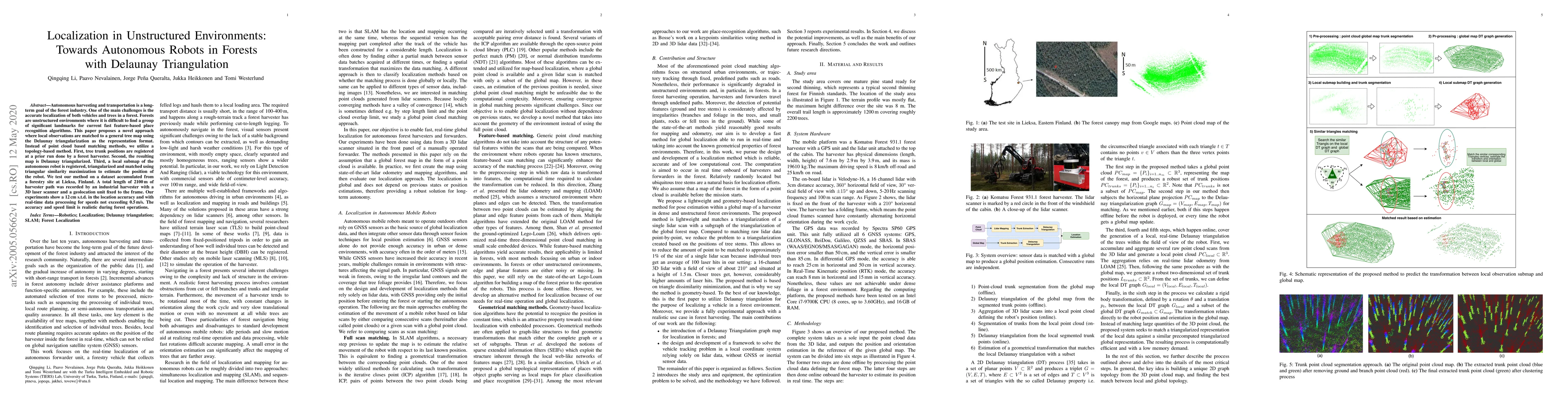
Autonomous harvesting and transportation is a long-term goal of the forest industry. One of the main challenges is the accurate localization of both vehicles and trees in a forest. Forests are unstructured environments where it is difficult to find a group of significant landmarks for current fast feature-based place recognition algorithms. This paper proposes a novel approach where local observations are matched to a general tree map using the Delaunay triangularization as the representation format. Instead of point cloud based matching methods, we utilize a topology-based method. First, tree trunk positions are registered at a prior run done by a forest harvester. Second, the resulting map is Delaunay triangularized. Third, a local submap of the autonomous robot is registered, triangularized and matched using triangular similarity maximization to estimate the position of the robot. We test our method on a dataset accumulated from a forestry site at Lieksa, Finland. A total length of 2100\,m of harvester path was recorded by an industrial harvester with a 3D laser scanner and a geolocation unit fixed to the frame. Our experiments show a 12\,cm s.t.d. in the location accuracy and with real-time data processing for speeds not exceeding 0.5\,m/s. The accuracy and speed limit is realistic during forest operations.
AI Key Findings
Get AI-generated insights about this paper's methodology, results, and significance.
Paper Details
How to Cite This Paper
@article{queralta2020localization,
  title         = {Localization in Unstructured Environments: Towards Autonomous Robots in
  Forests with Delaunay Triangulation},
  author        = {Queralta, Jorge Peña and Heikkonen, Jukka and Nevalainen, Paavo and others},
  year          = {2020},
  eprint        = {2005.05662},
  archivePrefix = {arXiv},
  primaryClass  = {cs.RO},
  doi           = {10.3390/rs12111870},
}Queralta, J., Heikkonen, J., Nevalainen, P., Li, Q., & Westerlund, T. (2020). Localization in Unstructured Environments: Towards Autonomous Robots in
Forests with Delaunay Triangulation. arXiv. https://doi.org/10.3390/rs12111870Queralta, Jorge Peña, et al. "Localization in Unstructured Environments: Towards Autonomous Robots in
Forests with Delaunay Triangulation." arXiv, 2020, doi.org/10.3390/rs12111870.PDF Preview
Key Terms
Citation Network
Current paper (gray), citations (green), references (blue)
Display is limited for performance on very large graphs.
Similar Papers
Found 4 papersFoundation Models for Autonomous Robots in Unstructured Environments
Hossein Naderi, Alireza Shojaei, Lifu Huang
DTR: Delaunay Triangulation-based Racing for Scaled Autonomous Racing
Luca Tognoni, Neil Reichlin, Edoardo Ghignone et al.
| Title | Authors | Year | Actions |
|---|
Comments (0)