Publication

Published: Mar 04, 2026
Categories: cs.CV, cs.RO

Metrics

Source: ArXiv

Quick Actions

View PDF

Quick Answers

What methodology did the authors use?

We curated a multi-site, multi-year AUV dataset with sub-decimeter registered stereo imagery, developed a footprint-based ground-truthing method that links camera views via overlapping 3‑D image footprints, and benchmarked eight state‑of‑the‑art visual place recognition models. More in Methodology →

What are the key results?

The dataset is the first curated long‑term benthic dataset covering five sites over up to six years, with sub‑decimeter pose accuracy. — Footprint‑based ground truth yields conservative, overlap‑aware links that avoid over‑estimation seen with distance‑threshold ground truth. More in Key Results →

Why is this work significant?

This work supplies a high‑quality benchmark and a principled ground‑truthing approach, enabling realistic evaluation and advancement of long‑term underwater visual localization systems. More in Significance →

What are the main limitations?

The dataset covers only five sites and a limited number of revisit intervals, constraining generalizability. — Evaluation is limited to single‑image descriptor‑based VPR without map‑building or uncertainty modeling. More in Limitations →

Paper Preview

Abstract

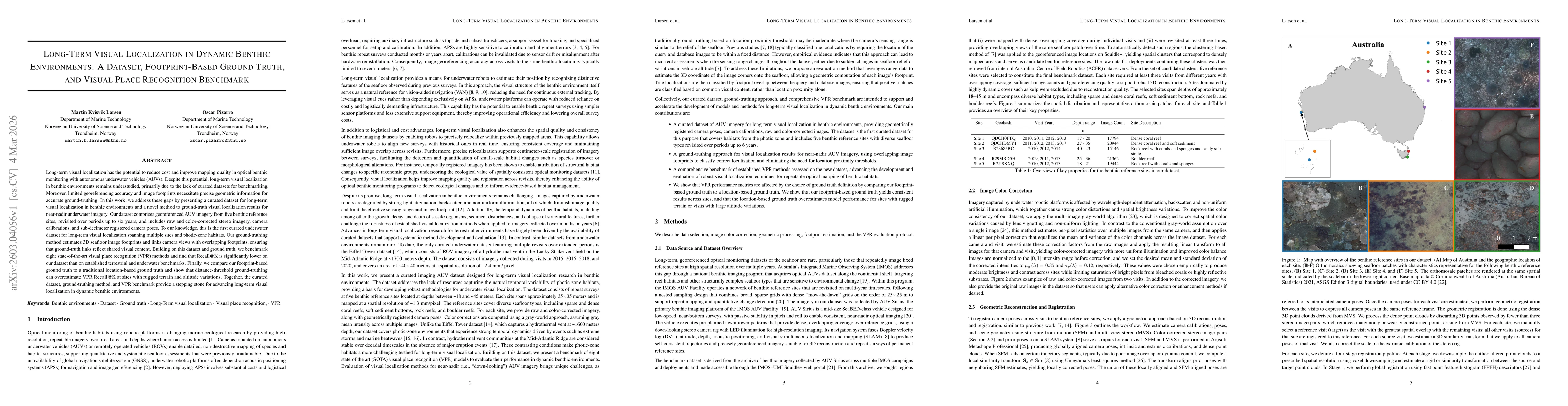
Long-term visual localization has the potential to reduce cost and improve mapping quality in optical benthic monitoring with autonomous underwater vehicles (AUVs). Despite this potential, long-term visual localization in benthic environments remains understudied, primarily due to the lack of curated datasets for benchmarking. Moreover, limited georeferencing accuracy and image footprints necessitate precise geometric information for accurate ground-truthing. In this work, we address these gaps by presenting a curated dataset for long-term visual localization in benthic environments and a novel method to ground-truth visual localization results for near-nadir underwater imagery. Our dataset comprises georeferenced AUV imagery from five benthic reference sites, revisited over periods up to six years, and includes raw and color-corrected stereo imagery, camera calibrations, and sub-decimeter registered camera poses. To our knowledge, this is the first curated underwater dataset for long-term visual localization spanning multiple sites and photic-zone habitats. Our ground-truthing method estimates 3D seafloor image footprints and links camera views with overlapping footprints, ensuring that ground-truth links reflect shared visual content. Building on this dataset and ground truth, we benchmark eight state-of-the-art visual place recognition (VPR) methods and find that Recall@K is significantly lower on our dataset than on established terrestrial and underwater benchmarks. Finally, we compare our footprint-based ground truth to a traditional location-based ground truth and show that distance-threshold ground-truthing can overestimate VPR Recall@K at sites with rugged terrain and altitude variations. Together, the curated dataset, ground-truthing method, and VPR benchmark provide a stepping stone for advancing long-term visual localization in dynamic benthic environments.

AI Key Findings

Generated Mar 05, 2026

Methodology — What approach did the authors take?

We curated a multi-site, multi-year AUV dataset with sub-decimeter registered stereo imagery, developed a footprint-based ground-truthing method that links camera views via overlapping 3‑D image footprints, and benchmarked eight state‑of‑the‑art visual place recognition models.

Key Results — What are the main findings?

  • The dataset is the first curated long‑term benthic dataset covering five sites over up to six years, with sub‑decimeter pose accuracy.
  • Footprint‑based ground truth yields conservative, overlap‑aware links that avoid over‑estimation seen with distance‑threshold ground truth.
  • Recall@K of all tested VPR models is markedly lower than on terrestrial or existing underwater benchmarks, with performance strongly dependent on seafloor texture and revisit interval.

Significance — Why does this research matter?

This work supplies a high‑quality benchmark and a principled ground‑truthing approach, enabling realistic evaluation and advancement of long‑term underwater visual localization systems.

Technical Contribution — What is the technical contribution?

A footprint‑based ground‑truthing framework that links near‑nadir underwater images based on 3‑D footprint overlap, coupled with the first long‑term benthic dataset and VPR benchmark.

Novelty — What is new about this work?

First curated long‑term underwater dataset spanning multiple photic‑zone habitats, combined with a novel overlap‑aware ground‑truth method that exposes the limitations of distance‑based evaluation.

Limitations — What are the limitations of this study?

  • The dataset covers only five sites and a limited number of revisit intervals, constraining generalizability.
  • Evaluation is limited to single‑image descriptor‑based VPR without map‑building or uncertainty modeling.

Future Work — What did the authors propose for future work?

  • Improve footprint estimation by sampling more image points or using advanced range‑map techniques.
  • Incorporate multi‑query trajectory context and map‑based representations to enhance localization robustness.

Paper Details

Paper ID: 2603.04056
Categories:
cs.CV cs.RO

How to Cite This Paper

BibTeX
@article{larsen2026long,
  title         = {Long-Term Visual Localization in Dynamic Benthic Environments: A Dataset, Footprint-Based Ground Truth, and Visual Place Recognition Benchmark},
  author        = {Larsen, Martin Kvisvik and Pizarro, Oscar},
  year          = {2026},
  eprint        = {2603.04056},
  archivePrefix = {arXiv},
  primaryClass  = {cs.CV},
}
APA 7
Larsen, M., & Pizarro, O. (2026). Long-Term Visual Localization in Dynamic Benthic Environments: A Dataset, Footprint-Based Ground Truth, and Visual Place Recognition Benchmark. arXiv. https://arxiv.org/abs/2603.04056
MLA 9
Larsen, Martin Kvisvik, and Oscar Pizarro. "Long-Term Visual Localization in Dynamic Benthic Environments: A Dataset, Footprint-Based Ground Truth, and Visual Place Recognition Benchmark." arXiv, 2026, arxiv.org/abs/2603.04056.

Similar Papers

Found 4 papers

Comments (0)

This website uses cookies to ensure you get the best experience. Learn more