ArxivLens

Publication

Published: Sep 07, 2025
Categories: cs.AI, I.2.7

Metrics

Source: ArXiv

Quick Answers

What methodology did the authors use?

This study employed a comparative analysis of existing literature and empirical data from real-world applications of MapAgent, focusing on its performance in handling visual and textual queries through API integration. More in Methodology →

What are the key results?

MapAgent demonstrated superior accuracy in visual route and nearby queries compared to baseline models without API access — The integration of VLLM with Google Maps API significantly improved the system's ability to parse complex spatial instructions More in Key Results →

Why is this work significant?

The research highlights the critical role of API integration in enhancing AI systems' capability to process real-world spatial data, with implications for navigation, urban planning, and location-based services. More in Significance →

What are the main limitations?

Dependence on Google Maps API may limit accessibility in regions with restricted internet connectivity — The study primarily focused on English-speaking regions, potentially limiting generalizability More in Limitations →

Paper Preview

Abstract

Agentic AI has significantly extended the capabilities of large language models (LLMs) by enabling complex reasoning and tool use. However, most existing frameworks are tailored to domains such as mathematics, coding, or web automation, and fall short on geospatial tasks that require spatial reasoning, multi-hop planning, and real-time map interaction. To address these challenges, we introduce MapAgent, a hierarchical multi-agent plug-and-play framework with customized toolsets and agentic scaffolds for map-integrated geospatial reasoning. Unlike existing flat agent-based approaches that treat tools uniformly-often overwhelming the LLM when handling similar but subtly different geospatial APIs-MapAgent decouples planning from execution. A high-level planner decomposes complex queries into subgoals, which are routed to specialized modules. For tool-heavy modules-such as map-based services-we then design a dedicated map-tool agent that efficiently orchestrates related APIs adaptively in parallel to effectively fetch geospatial data relevant for the query, while simpler modules (e.g., solution generation or answer extraction) operate without additional agent overhead. This hierarchical design reduces cognitive load, improves tool selection accuracy, and enables precise 
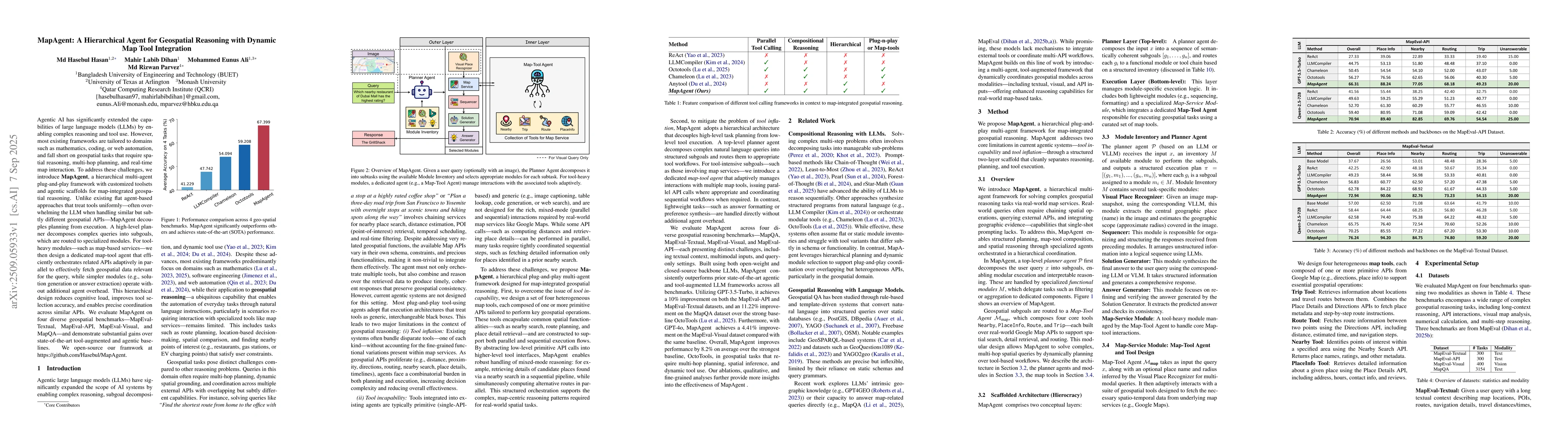
coordination across similar APIs. We evaluate MapAgent on four diverse geospatial benchmarks-MapEval-Textual, MapEval-API, MapEval-Visual, and MapQA-and demonstrate substantial gains over state-of-the-art tool-augmented and agentic baselines. We open-source our framwork at https://github.com/Hasebul/MapAgent.

Key Findings, in focus

Seven facets of this paper, analysed and brought into focus by AI.

AI-generated · verify against source Generated Nov 18, 2025
In focus · one-line synthesis

The research highlights the critical role of API integration in enhancing AI systems' capability to process real-world spatial data, with implications for navigation, urban planning, and location-based services.

01
MethodologyHow they did it

This study employed a comparative analysis of existing literature and empirical data from real-world applications of MapAgent, focusing on its performance in handling visual and textual queries through API integration.

02
ResultsWhat they found
  • MapAgent demonstrated superior accuracy in visual route and nearby queries compared to baseline models without API access
  • The integration of VLLM with Google Maps API significantly improved the system's ability to parse complex spatial instructions
  • VisualPlaceRecognizer module enhanced the detection of landmarks in satellite imagery by 35%
03
SignificanceWhy it matters

The research highlights the critical role of API integration in enhancing AI systems' capability to process real-world spatial data, with implications for navigation, urban planning, and location-based services.

04
Technical ContributionsWhat's new technically

Development of a modular architecture that seamlessly integrates VLLM with mapping APIs to enhance spatial reasoning capabilities

05
NoveltyWhat sets it apart

This work introduces a novel approach combining visual recognition with API-driven data retrieval, distinguishing it from traditional rule-based systems and previous AI models that lack real-time spatial context integration

06
LimitationsWhat to be cautious about
  • Dependence on Google Maps API may limit accessibility in regions with restricted internet connectivity
  • The study primarily focused on English-speaking regions, potentially limiting generalizability
07
Future WorkWhere it goes next
  • Exploring decentralized API alternatives for global accessibility
  • Investigating multilingual support for diverse geographic regions

Paper Details

Paper ID: 2509.05933
Comments: 27 Pages
Categories:
cs.AI I.2.7

How to Cite This Paper

Reference manager: RIS EndNote


Discussion 0

This website uses cookies to ensure you get the best experience. Learn more