Authors
Summary
Quantitative analysis of historical urban sprawl in France before the 1970s is hindered by the lack of nationwide digital urban footprint data. This study bridges this gap by developing a scalable deep learning pipeline to extract urban areas from the Scan Histo historical map series (1925-1950), which produces the first open-access, national-scale urban footprint dataset for this pivotal period. Our key innovation is a dual-pass U-Net approach designed to handle the high radiometric and stylistic complexity of historical maps. The first pass, trained on an initial dataset, generates a preliminary map that identifies areas of confusion, such as text and roads, to guide targeted data augmentation. The second pass uses a refined dataset and the binarized output of the first model to minimize radiometric noise, which significantly reduces false positives. Deployed on a high-performance computing cluster, our method processes 941 high-resolution tiles covering the entirety of metropolitan France. The final mosaic achieves an overall accuracy of 73%, effectively capturing diverse urban patterns while overcoming common artifacts like labels and contour lines. We openly release the code, training datasets, and the resulting nationwide urban raster to support future research in long-term urbanization dynamics.
AI Key Findings
Generated Oct 04, 2025
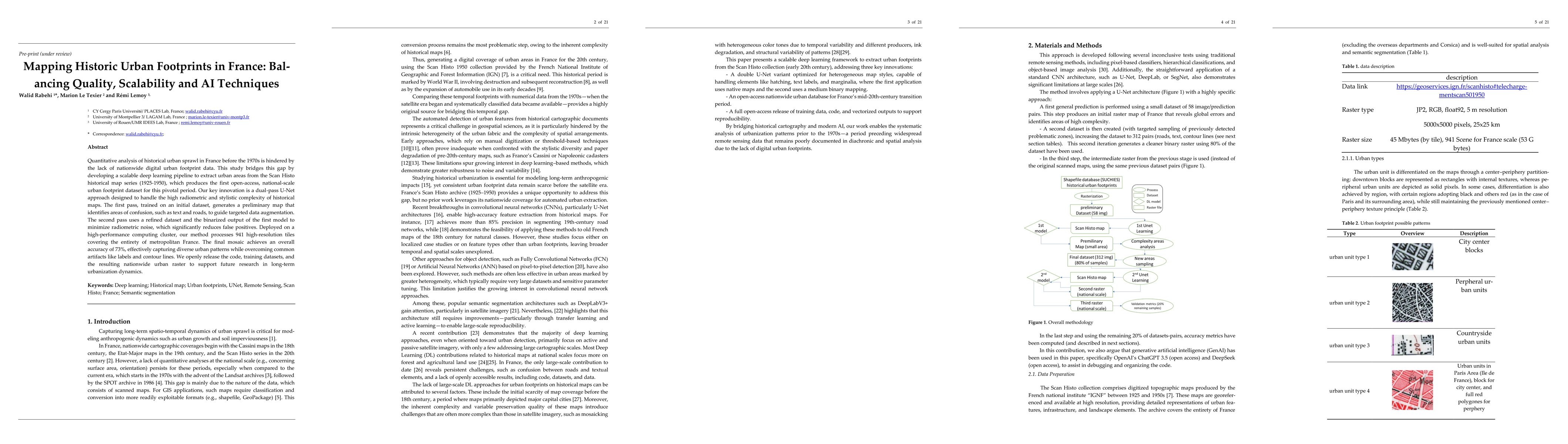
Methodology
The study employs a dual-pass U-Net deep learning approach to extract urban areas from historical Scan Histo maps (1925-1950). The first pass identifies areas of confusion, while the second pass refines the results using a binary mask to reduce false positives. The model is trained on a labeled dataset and validated using standard segmentation metrics like IoU, precision, and recall.
Key Results
- The final mosaic achieved an overall accuracy of 73% in capturing urban patterns across metropolitan France.
- The dual-pass U-Net significantly reduced false positives compared to single-pass methods, especially for features like roads and text.
- The method successfully segmented urban areas with high spatial coherence, achieving up to 91% accuracy in scenes with high-quality training data.
Significance
This research provides the first open-access, national-scale urban footprint dataset for France before the 1970s, enabling long-term urbanization studies. It bridges a critical gap in historical urban data, supporting comparative analyses of urban sprawl and its socio-economic impacts.
Technical Contribution
The study introduces a scalable deep learning pipeline optimized for historical map segmentation, combining geospatial awareness with iterative refinement to handle radiometric and stylistic complexities of historical data.
Novelty
The dual-pass U-Net approach with targeted data augmentation and binary refinement is novel, offering improved accuracy and reduced false positives in historical map segmentation compared to traditional methods and single-pass deep learning models.
Limitations
- Accuracy remains lower in rural areas with complex textures and heterogeneous map styles (45-60% accuracy).
- The method struggles with preserving precise shapes of urban blocks due to cartographic inconsistencies.
Future Work
- Integration with earlier and later map series to create continuous historical urban datasets.
- Exploration of multi-class segmentation and optical character recognition (OCR) for text extraction.
- Benchmarking against other deep learning models and improving temporal generalization.
Paper Details
PDF Preview
Similar Papers
Found 4 papersMapping Inequalities in Activity-based Carbon Footprints of Urban Dwellers using Fine-grained Human Trajectory Data
Ali Mostafavi, Yuqin Jiang, Sanjay Nayak et al.
Comments (0)