Quick Summary:

Researchers developed an active learning method to estimate oil palm density from Sentinel-2 satellite images, creating high-resolution maps for Malaysia and Indonesia with accuracy of 7.3 trees/ha.

Summary

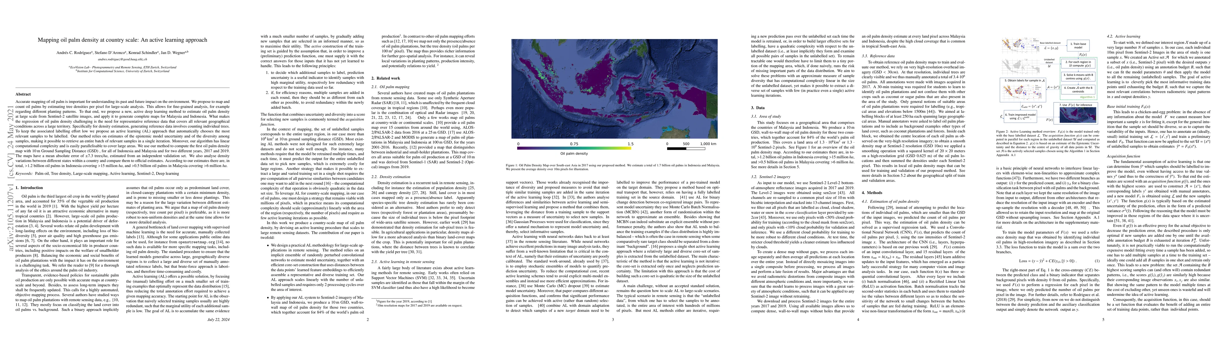
Accurate mapping of oil palm is important for understanding its past and future impact on the environment. We propose to map and count oil palms by estimating tree densities per pixel for large-scale analysis. This allows for fine-grained analysis, for example regarding different planting patterns. To that end, we propose a new, active deep learning method to estimate oil palm density at large scale from Sentinel-2 satellite images, and apply it to generate complete maps for Malaysia and Indonesia. What makes the regression of oil palm density challenging is the need for representative reference data that covers all relevant geographical conditions across a large territory. Specifically for density estimation, generating reference data involves counting individual trees. To keep the associated labelling effort low we propose an active learning (AL) approach that automatically chooses the most relevant samples to be labelled. Our method relies on estimates of the epistemic model uncertainty and of the diversity among samples, making it possible to retrieve an entire batch of relevant samples in a single iteration. Moreover, our algorithm has linear computational complexity and is easily parallelisable to cover large areas. We use our method to compute the first oil palm density map with $10\,$m Ground Sampling Distance (GSD) , for all of Indonesia and Malaysia and for two different years, 2017 and 2019. The maps have a mean absolute error of $\pm$7.3 trees/$ha$, estimated from an independent validation set. We also analyse density variations between different states within a country and compare them to official estimates. According to our estimates there are, in total, $>1.2$ billion oil palms in Indonesia covering $>$15 million $ha$, and $>0.5$ billion oil palms in Malaysia covering $>6$ million $ha$.

AI Key Findings

Get AI-generated insights about this paper's methodology, results, and significance.

Paper Details

PDF Preview

Download PDF

Key Terms

oil (0.349)
million (0.183)
trees (0.169)
million (0.168)
estimates (0.167)
covering (0.167)
samples (0.163)
relevant (0.163)
trees (0.161)
samples (0.158)
estimates (0.156)
covering (0.156)
relevant (0.156)
reference (0.155)
density (0.154)
density (0.147)
reference (0.145)
maps (0.143)
active (0.139)
map (0.138)

Citation Network

Current paper (gray), citations (green), references (blue)

Current Paper
Citations
References
Click to view
Title Authors Year Actions
Lossy Neural Compression for Geospatial Analytics: A Review
Carlos Gomes, Isabelle Wittmann, Damien Robert, Johannes Jakubik, Tim Reichelt, Michele Martone, Stefano Maurogiovanni, Rikard Vinge, Jonas Hurst, Erik Scheurer, Rocco Sedona, Thomas Brunschwiler, Stefan Kesselheim, Matej Batic, Philip Stier, Jan Dirk Wegner, Gabriele Cavallaro, E. Pebesma, Michael Marszalek, M. A. Belenguer-Plomer, Kennedy Adriko, P. Fraccaro, Romeo Kienzler, Rania Briq, Sabrina Benassou, Michele Lazzarini, Conrad M Albrecht
2025
View Paper
Mapping oil palm plantations and their implications on forest and great ape habitat loss in Central Africa
M. Ozigis, Serge A. Wich, Adrià Descals, Z. Szantoi, Erik Meijaard
2024
View Paper
Impact of Industry 4.0 Technologies on the Oil Palm Industry: A Literature Review
Mohamad Zaki Mohamad Akmal, Jecksin Ooi, W. P. Ng, B. S. How, Hon Loong Lam, Dominic C.Y. Foo, C. Lim
2024
View Paper
Synthesis of geopolymer mortar incorporating date palm ash
Yousef R. Alharbi, Abdulrahman Albidah
2024
View Paper
Earth Observation and Machine Learning for Climate Change
R. Hänsch, M. Chaurasia
2024
View Paper
Regimes of global and national oil palm cultivations from 2001 to 2018
Hao Yu, Dongjie Fu, Ze Yuan, Jiasheng Tang, Ye Xiao, Lu Kang, Vincent Lyne, Fenzhen Su
2024
View Paper
A new Bayesian semi-supervised active learning framework for large-scale crop mapping using Sentinel-2 imagery
Yijia Xu, Jing Zhou, Zhou Zhang
2024
View Paper
An industry 4.0 adoption in the circular economy application hierarchical model: driver, enable and barrier aspects
Asma-Qamaliah Abdul-Hamid, Mohd Helmi Ali, Lokhman Hakim Osman, Ming‐Lang Tseng, Ahmad Raflis Che Omar
2023
View Paper
Active Learning-Based Species Range Estimation
Christian Lange, Elijah Cole, Grant Van Horn, Oisin Mac Aodha
2023
View Paper
Diversity-based active learning: creating a representative object detection dataset in 3D point clouds
Aimee Moses, C. Bogart, Kelsey O'Haire, Lidia Solorzano, Elinor Yeo
2023
View Paper
Mapping Eucalyptus plantation in Guangxi, China by using knowledge-based algorithms and PALSAR-2, Sentinel-2, and Landsat images in 2020
Chenchen Zhang, Xiangming Xiao, Liangcheng Zhao, Yuanwei Qin, R. Doughty, Xinxin Wang, Jinwei Dong, Xuebin Yang
2023
View Paper
Toward the remote monitoring of armed conflicts
V. Sticher, J. D. Wegner, Birke Pfeifle
2023
View Paper
Artificial Intelligence to Advance Earth Observation: A review of models, recent trends, and pathways forward
D. Tuia, Konrad Schindler, Begum Demir, Xiao Xiang Zhu, M. Kochupillai, S. Džeroski, Jan N. van Rijn, Holger H. Hoos, Fabio Del Frate, Mihai Datcu, Volker Markl, Bertrand Le Saux, Rochelle Schneider, G. Camps-Valls
2023
View Paper
Cocoa plantations are associated with deforestation in Côte d’Ivoire and Ghana
Nikolai Kalischek, Nico Lang, Cécile Renier, R. C. Daudt, Thomas Addoah, W. Thompson, W. Blaser-Hart, R. Garrett, K. Schindler, J. D. Wegner
2023
View Paper
Smallholder oil palm plantation sustainability assessment using multi-criteria analysis and unmanned aerial vehicles
Yong Bin Wong, C. Gibbins, B. Azhar, Su Shen Phan, P. Scholefield, R. Azmi, A. Lechner
2023
View Paper
The Impacts of Quality-Oriented Dataset Labeling on Tree Cover Segmentation Using U-Net: A Case Study in WorldView-3 Imagery
Tao Jiang, Maximilian Freudenberg, C. Kleinn, Alexander S. Ecker, Nils Nölke
2023
View Paper
Graph-Based View Motion Planning for Fruit Detection
Tobias Zaenker, Julius Rückin, Rohit Menon, Marija Popovi'c, Maren Bennewitz
2023
View Paper
An Informative Path Planning Framework for Active Learning in UAV-Based Semantic Mapping
Julius Ruckin, Federico Magistri, C. Stachniss, Marija Popovi'c
2023
View Paper
Investigating the Potential Use of Date Kernel Ash (DKA) as a Partial Cement Replacement in Concrete
Muneer K. Saeed, M. Rahman, Mohammed Alfawzan, S. Basha, H. A. Dahish
2022
View Paper
OIL PALM ECONOMIC PERFORMANCE IN MALAYSIA AND R&D PROGRESS IN 2021
Ahmad Parveez GHULAM KADIR
2022
View Paper
A Review: Progression of Remote Sensing (RS) and Geographical Information System (GIS) Applications in Oil Palm Management and Sustainability
Mohd Sharul Aikal Baharim, N. Adnan, F. A. Mohd, I. A. Seman, M. Izzuddin, Nordiana Abd Aziz
2022
View Paper
Satellite-based high-resolution maps of cocoa planted area for Côte d'Ivoire and Ghana
Nikolai Kalischek, Nico Lang, Cécile Renier, R. C. Daudt, Thomas Addoah, W. Thompson, W. Blaser-Hart, R. Garrett, K. Schindler, J. D. Wegner
2022
View Paper
A high-resolution canopy height model of the Earth
Nico Lang, W. Jetz, K. Schindler, J. D. Wegner
2022
View Paper
Informative Path Planning for Active Learning in Aerial Semantic Mapping
Julius Ruckin, Liren Jin, Federico Magistri, C. Stachniss, Marija Popovi'c
2022
View Paper
Oil Palm Yield Estimation Based on Vegetation and Humidity Indices Generated from Satellite Images and Machine Learning Techniques
Fernando Watson-Hernández, Natalia Gómez-Calderón, R. P. da Silva
2022
View Paper
A novel ensemble machine learning and time series approach for oil palm yield prediction using Landsat time series imagery based on NDVI
H. Shafri, Y. Ang, S. A. Bakar, H. Abidin, Yang Ping Lee, S. Hashim, Nik Norasma Che'ya, M. R. Hassan, H. S. Lim, R. Abdullah
2022
View Paper
Country-wide retrieval of forest structure from optical and SAR satellite imagery with deep ensembles
Alexander Becker, S. Russo, Stefano Puliti, Nico Lang, K. Schindler, J. D. Wegner
2021
View Paper
Robust Damage Estimation of Typhoon Goni on Coconut Crops with Sentinel-2 Imagery
Andrés C. Rodríguez, R. C. Daudt, Stefano D'aronco, K. Schindler, J. D. Wegner
2021
View Paper
Active Learning for Improved Semi-Supervised Semantic Segmentation in Satellite Images
S. Desai, Debasmita Ghose
2021
View Paper
Deep learning for sub-pixel palm tree classification using spaceborne Sentinel-2 imagery
M. Culman, Andrés C. Rodríguez, J. D. Wegner, S. Delalieux, B. Somers
2021
View Paper
Mapping Vulnerable Populations with AI
B. Kellenberger, John E. Vargas-Muñoz, D. Tuia, R. C. Daudt, K. Schindler, Thao T-T Whelan, Brenda Ayo, Ferda Ofli, Muhammad Imran
2021
View Paper
High carbon stock mapping at large scale with optical satellite imagery and spaceborne LIDAR
Nico Lang, K. Schindler, J. D. Wegner
2021
View Paper
Single Oil Palm Tree Detection and Its Potential Expansion in Honduras
Hang Zhang, Yaoping Cui, Le Yu, Rafael Enrique Corrales Andino, Sen Zhang, Kailong Cui, Tianwei Zhao, Han Liang
2025
View Paper
Investigating the possibility of using date kernel ash as supplementary cementitious material in sustainable concrete
Farah Alaa Alwash, Boris Bulgakov
2024
View Paper
Artificial intelligence to advance Earth observation: a perspective
D. Tuia, K. Schindler, B. Demir, Gustau Camps-Valls, Xiao Xiang Zhu, M. Kochupillai, Savso Dvzeroski, J. N. Rijn, H. Hoos, F. Frate, M. Datcu, Jorge-Arnulfo Quian'e-Ruiz, V. Markl, B. L. Saux, Rochelle Schneider
2023
View Paper
Satellite-based high-resolution maps of cocoa for Côte d’Ivoire and Ghana
Nikolai Kalischek, Nico Lang, Cécile Renier, R. C. Daudt, Thomas Addoah, W. Thompson, W. Blaser-Hart, R. Garrett, K. Schindler, J. D. Wegner
2022
View Paper
Country-wide Retrieval of Forest Structure From Optical and SAR Satellite Imagery With Bayesian Deep Learning
Alexander Becker, S. Russo, Stefano Puliti, Nico Lang, K. Schindler, J. D. Wegner
2021
View Paper
The potential of Nephrolepis biserrata fern as ground cover vegetation in oil palm plantation
H. Satriawan, Z. Fuady
2021
View Paper
oil palm plantations and their implications on forest and
M. Ozigis, Serge A. Wich, Descals, Z. Szantoi, Erik Meijaard
View Paper
Edinburgh Research Explorer Active Learning-Based Species Range Estimation
Christian Lange, Elijah Cole, Grant Van Horn, Oisin Mac Aodha
View Paper

Comments (0)

This website uses cookies to ensure you get the best experience. Learn more