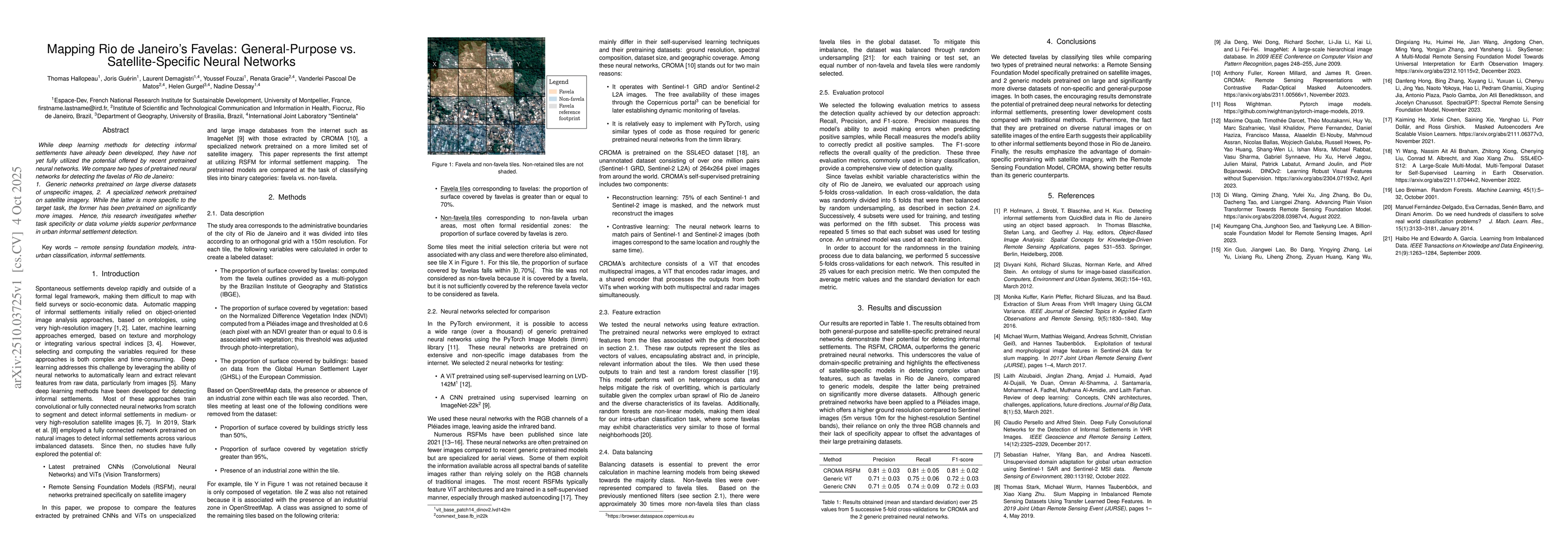
ArxivLens

Publication

Published: Oct 04, 2025
Categories: cs.CV, cs.LG

Metrics

Source: ArXiv

Quick Answers

What methodology did the authors use?

The study compares two pretrained neural networks: generic models trained on diverse internet images and a satellite-specific model (CROMA) trained on satellite imagery. They extract features from tiles of Rio de Janeiro's area and use random forest classifiers to evaluate performance using precision, recall, and F1-score metrics with cross-validation. More in Methodology →

What are the key results?

CROMA (satellite-specific) outperformed generic models with higher precision (0.81±0.03), recall (0.81±0.05), and F1-score (0.81±0.02) compared to generic ViT (0.71±0.03, 0.75±0.06, 0.72±0.03) and CNN (0.71±0.05, 0.74±0.09, 0.72±0.03). — Task specificity (satellite-specific models) yielded better performance than data volume (generic models) despite the latter being trained on more diverse images. More in Key Results →

Why is this work significant?

This research demonstrates the potential of domain-specific pretraining for urban informal settlement detection, offering lower development costs and broader applicability beyond Rio de Janeiro's favelas. More in Significance →

What are the main limitations?

The study focused on Rio de Janeiro's favelas, limiting generalizability to other urban contexts. — Data balancing through random undersampling may affect model performance on real-world imbalanced datasets. More in Limitations →

Paper Preview

Abstract

While deep learning methods for detecting informal settlements have already been developed, they have not yet fully utilized the potential offered by recent pretrained neural networks. We compare two types of pretrained neural networks for detecting the favelas of Rio de Janeiro: 1. Generic networks pretrained on large diverse datasets of unspecific images, 2. A specialized network pretrained on satellite imagery. While the latter is more specific to the target task, the former has been pretrained on significantly more images. Hence, this research investigates whether task specificity or data volume yields superior performance in urban informal settlement detection.

Key Findings, in focus

Seven facets of this paper, analysed and brought into focus by AI.

AI-generated · verify against source Generated Oct 11, 2025
In focus · one-line synthesis

This research demonstrates the potential of domain-specific pretraining for urban informal settlement detection, offering lower development costs and broader applicability beyond Rio de Janeiro's favelas.

01
MethodologyHow they did it

The study compares two pretrained neural networks: generic models trained on diverse internet images and a satellite-specific model (CROMA) trained on satellite imagery. They extract features from tiles of Rio de Janeiro's area and use random forest classifiers to evaluate performance using precision, recall, and F1-score metrics with cross-validation.

02
ResultsWhat they found
  • CROMA (satellite-specific) outperformed generic models with higher precision (0.81±0.03), recall (0.81±0.05), and F1-score (0.81±0.02) compared to generic ViT (0.71±0.03, 0.75±0.06, 0.72±0.03) and CNN (0.71±0.05, 0.74±0.09, 0.72±0.03).
  • Task specificity (satellite-specific models) yielded better performance than data volume (generic models) despite the latter being trained on more diverse images.
  • The study highlights the effectiveness of satellite-specific models in detecting complex urban features like favelas, even with smaller, specialized datasets.
03
SignificanceWhy it matters

This research demonstrates the potential of domain-specific pretraining for urban informal settlement detection, offering lower development costs and broader applicability beyond Rio de Janeiro's favelas.

04
Technical ContributionsWhat's new technically

The paper presents the first application of Remote Sensing Foundation Models (RSFM) for informal settlement mapping, demonstrating their effectiveness compared to generic pre-trained models.

05
NoveltyWhat sets it apart

This work is novel as it is the first attempt to utilize RSFM for informal settlement detection, comparing task specificity with data volume in a real-world urban mapping scenario.

06
LimitationsWhat to be cautious about
  • The study focused on Rio de Janeiro's favelas, limiting generalizability to other urban contexts.
  • Data balancing through random undersampling may affect model performance on real-world imbalanced datasets.
07
Future WorkWhere it goes next
  • Exploring the application of RSFM to other informal settlements in different regions.
  • Investigating hybrid models combining generic and satellite-specific pretraining for improved performance.
  • Enhancing data collection methods to include more diverse and representative satellite imagery.

Paper Details

Paper ID: 2510.03725
Comments: 6 pages, 1 figure, 1 table. Presented at the 21st Brazilian Symposium on Remote Sensing (SBSR 2025)
Categories:
cs.CV cs.LG

How to Cite This Paper

Reference manager: RIS EndNote


Discussion 0

This website uses cookies to ensure you get the best experience. Learn more