A new software library called MapReader enables historians to analyze large map collections using machine learning, transforming the way they search and interpret primary sources. The system has been tested on a collection of 30.5 million patches from 19th-century Ordnance Survey maps.
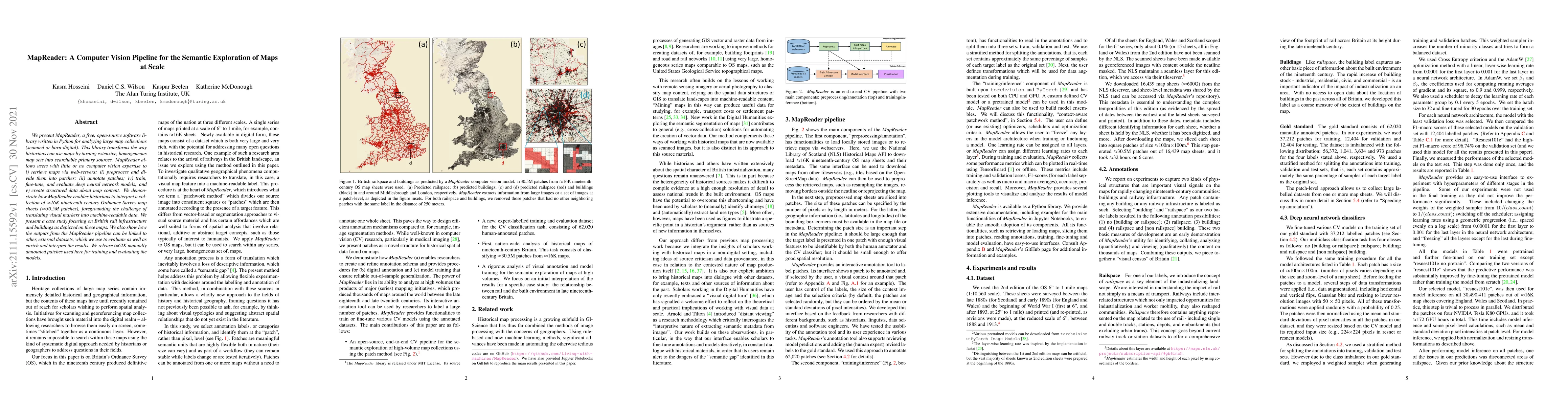
We present MapReader, a free, open-source software library written in Python for analyzing large map collections (scanned or born-digital). This library transforms the way historians can use maps by turning extensive, homogeneous map sets into searchable primary sources. MapReader allows users with little or no computer vision expertise to i) retrieve maps via web-servers; ii) preprocess and divide them into patches; iii) annotate patches; iv) train, fine-tune, and evaluate deep neural network models; and v) create structured data about map content. We demonstrate how MapReader enables historians to interpret a collection of $\approx$16K nineteenth-century Ordnance Survey map sheets ($\approx$30.5M patches), foregrounding the challenge of translating visual markers into machine-readable data. We present a case study focusing on British rail infrastructure and buildings as depicted on these maps. We also show how the outputs from the MapReader pipeline can be linked to other, external datasets, which we use to evaluate as well as enrich and interpret the results. We release $\approx$62K manually annotated patches used here for training and evaluating the models.
Get AI-generated insights about this paper's methodology, results, and significance.
Current paper (gray), citations (green), references (blue)
Title | Authors | Year | Actions |
---|---|---|---|
Segmenting France Across Four Centuries
|
Marta L'opez-Rauhut, Hongyu Zhou, Mathieu Aubry, Lo¨ıc Landrieu
|
2025
|
View Paper |
Automated dynamic phenotyping of whole oilseed rape (Brassica napus) plants from images collected under controlled conditions
|
Evangeline Corcoran, Kasra Hosseini, Laura Siles, Smita Kurup, Sebastian Ahnert
|
2025
|
View Paper |
Mapping Ghent’s cultural heritage: a place-based approach with web GIS
|
Vincent Ducatteeuw, Fien Danniau, Christophe Verbruggen
|
2025
|
View Paper |
Estimating the density of urban trees in 1890s Leeds and Edinburgh using object detection on historical maps
|
Eleanor S. Smith, Christopher Fleet, Stuart King, William Mackaness, Hannah Walker, Catherine E. Scott
|
2025
|
View Paper |
FastPlan: A three-step framework for accelerating drone-centric search operations in post-disaster relief
|
Sunho Lim, Ingyu Lee, Gyu Sang Choi, Jinseok Chae, Ellora Ashish, Eric Ward, Cong Pu
|
2025
|
View Paper |
Visual Navigation of Digital Libraries: Retrieval and Classification of Images in the National Library of Norway's Digitised Book Collection
|
Marie Roald, M. B. Birkenes, Lars Gunnarsonn Bagoien Johnsen
|
2024
|
View Paper |
Integrating Visual and Textual Inputs for Searching Large-Scale Map Collections with CLIP
|
Jamie Mahowald, Benjamin Charles Germain Lee
|
2024
|
View Paper |
MapReader: Open software for the visual analysis of maps
|
Rosie Wood, Kasra Hosseini, Kalle Westerling, Andrew Smith, K. Beelen, Daniel C. S. Wilson, Katherine McDonough
|
2024
|
View Paper |
An Automated Georeferencing Workflow for Processing Historical Sanborn Fire Insurance Maps Using Object Detection and Optical Character Recognition
|
Michael G. Shensky, Katherine M. Strickland, Alexander W. Marden, Hannah Dubbe
|
2024
|
View Paper |
Built-up areas of nineteenth-century Britain. An integrated methodology for extracting high-resolution urban footprints from historical maps
|
A. Litvine, Arthur Starzec, Rehmana Younis, Yannick Faula, Mickael Coustaty, L. Shaw-Taylor, Véronique Églin
|
2024
|
View Paper |
Unleashing the power of old maps: Extracting symbology from nineteenth century maps using convolutional neural networks to quantify modern land use on historic wetlands
|
Rob O'Hara, R. Marwaha, Jesko Zimmerman, Matthew Saunders, S. Green
|
2024
|
View Paper |
Artificial intelligence studies in cartography: a review and synthesis of methods, applications, and ethics
|
Yuhao Kang, Song Gao, Robert E. Roth
|
2023
|
View Paper |
Towards the automated large-scale reconstruction of past road networks from historical maps
|
Johannes H. Uhl, S. Leyk, Yao-Yi Chiang, Craig A. Knoblock
|
2022
|
View Paper |
Road network evolution in the urban and rural United States since 1900
|
K. Burghardt, Johannes H. Uhl, Kristina Lerman, S. Leyk
|
2021
|
View Paper |
Comments (0)