MatchPlant: An Open-Source Pipeline for UAV-Based Single-Plant Detection and Data Extraction
Publication
Metrics
Paper Preview
Abstract
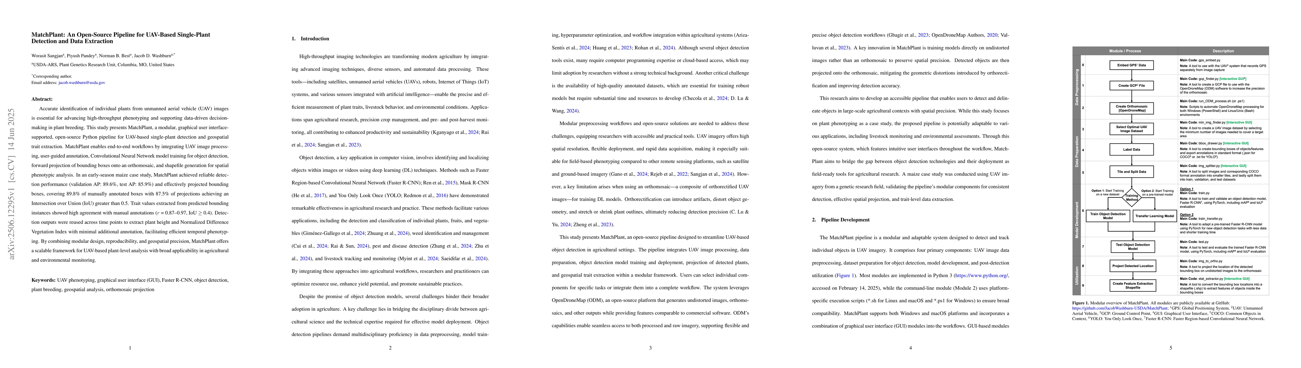
Accurate identification of individual plants from unmanned aerial vehicle (UAV) images is essential for advancing high-throughput phenotyping and supporting data-driven decision-making in plant breeding. This study presents MatchPlant, a modular, graphical user interface-supported, open-source Python pipeline for UAV-based single-plant detection and geospatial trait extraction. MatchPlant enables end-to-end workflows by integrating UAV image processing, user-guided annotation, Convolutional Neural Network model training for object detection, forward projection of bounding boxes onto an orthomosaic, and shapefile generation for spatial phenotypic analysis. In an early-season maize case study, MatchPlant achieved reliable detection performance (validation AP: 89.6%, test AP: 85.9%) and effectively projected bounding boxes, covering 89.8% of manually annotated boxes with 87.5% of projections achieving an Intersection over Union (IoU) greater than 0.5. Trait values extracted from predicted bounding instances showed high agreement with manual annotations (r = 0.87-0.97, IoU >= 0.4). Detection outputs were reused across time points to extract plant height and Normalized Difference Vegetation Index with minimal additional annotation, facilitating efficient temporal phenotyping. By combining modular design, reproducibility, and geospatial precision, MatchPlant offers a scalable framework for UAV-based plant-level analysis with broad applicability in agricultural and environmental monitoring.
AI Key Findings
Get AI-generated insights about this paper's methodology, results, significance, and more — seven facets brought into focus.
Impact
Paper Details
Authors
PDF Preview
Citation Network
Current paper (gray), citations (green), references (blue)
Display is limited for performance on very large graphs.
Discussion 0