ArxivLens
ArXiv cs.CV math.NA

Mathematical Analysis of Image Matching Techniques

Oleh Samoilenko

2604.07574 Proceedings of the Institute of Applied Mathematics and Mechanics NAS of Ukraine, 39 (2025) DOI: 10.37069/1683-4720-2025-39-8 Published Apr 8, 2026
View PDF

Publication

Published: Apr 08, 2026
Categories: cs.CV, math.NA

Metrics

Source: ArXiv

Quick Answers

What methodology did the authors use?

The study employed a standard feature‑matching pipeline on a GPS‑annotated satellite image dataset, including keypoint detection (SIFT/ORB), descriptor extraction, brute‑force matching, RANSAC homography estimation, and Inlier Ratio evaluation across varying keypoint counts. More in Methodology →

What are the key results?

SIFT consistently achieved higher Inlier Ratios than ORB for all keypoint configurations. — Increasing keypoints beyond 200–500 yields marginal Inlier Ratio gains, indicating diminishing returns. More in Key Results →

Why is this work significant?

The work offers a quantitative benchmark for classical local‑feature matching on satellite imagery, guiding practitioners in selecting efficient descriptors under computational constraints. More in Significance →

What are the main limitations?

The evaluation was limited to a single manually annotated dataset of overlapping tiles, potentially restricting generalizability. — Only two descriptors (SIFT and ORB) were compared, excluding other modern or learning‑based methods. More in Limitations →

Paper Preview

Abstract

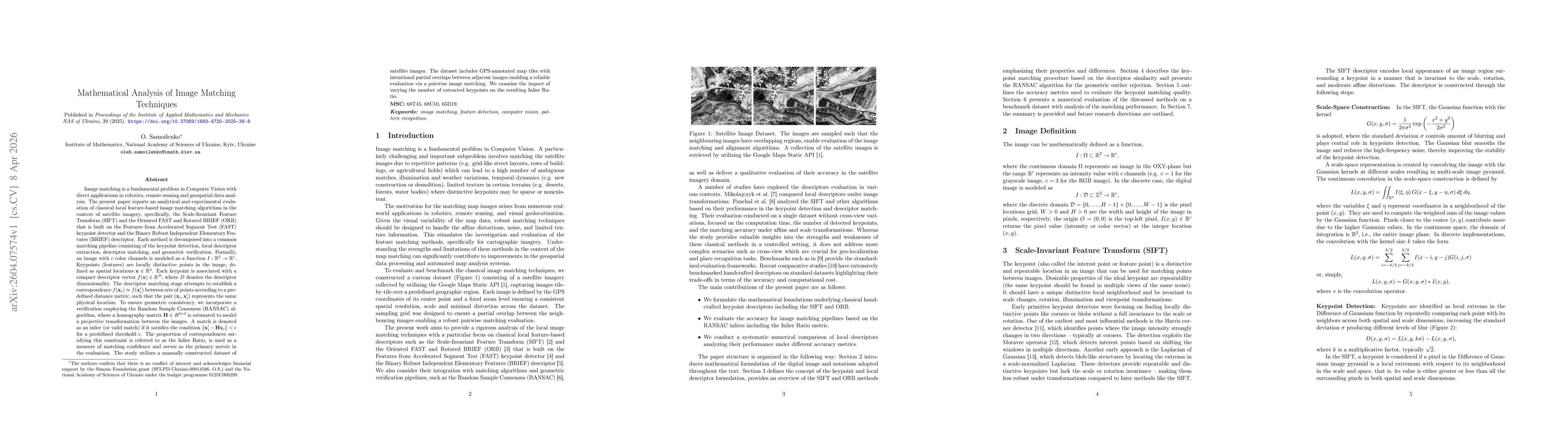
Image matching is a fundamental problem in Computer Vision with direct applications in robotics, remote sensing, and geospatial data analysis. We present an analytical and experimental evaluation of classical local feature-based image matching algorithms on satellite imagery, focusing on the Scale-Invariant Feature Transform (SIFT) and the Oriented FAST and Rotated BRIEF (ORB). Each method is evaluated through a common pipeline: keypoint detection, descriptor extraction, descriptor matching, and geometric verification via RANSAC with homography estimation. Matching quality is assessed using the Inlier Ratio - the fraction of correspondences consistent with the estimated homography. The study uses a manually constructed dataset of GPS-annotated satellite image tiles with intentional overlaps. We examine the impact of the number of extracted keypoints on the resulting Inlier Ratio.

Key Findings, in focus

Seven facets of this paper, analysed and brought into focus by AI.

AI-generated · verify against source Generated Apr 11, 2026
In focus · one-line synthesis

The work offers a quantitative benchmark for classical local‑feature matching on satellite imagery, guiding practitioners in selecting efficient descriptors under computational constraints.

01
MethodologyHow they did it

The study employed a standard feature‑matching pipeline on a GPS‑annotated satellite image dataset, including keypoint detection (SIFT/ORB), descriptor extraction, brute‑force matching, RANSAC homography estimation, and Inlier Ratio evaluation across varying keypoint counts.

02
ResultsWhat they found
  • SIFT consistently achieved higher Inlier Ratios than ORB for all keypoint configurations.
  • Increasing keypoints beyond 200–500 yields marginal Inlier Ratio gains, indicating diminishing returns.
  • Even with only 100 keypoints, SIFT outperformed ORB with 2000 keypoints, highlighting its robustness.
03
SignificanceWhy it matters

The work offers a quantitative benchmark for classical local‑feature matching on satellite imagery, guiding practitioners in selecting efficient descriptors under computational constraints.

04
Technical ContributionsWhat's new technically

A systematic framework that measures matching reliability via Inlier Ratio, applied to satellite imagery, and demonstrates the impact of keypoint quantity on descriptor performance.

05
NoveltyWhat sets it apart

First comparative study of SIFT versus ORB on satellite tiles using Inlier Ratio across keypoint counts, revealing a practical trade‑off for resource‑constrained deployments.

06
LimitationsWhat to be cautious about
  • The evaluation was limited to a single manually annotated dataset of overlapping tiles, potentially restricting generalizability.
  • Only two descriptors (SIFT and ORB) were compared, excluding other modern or learning‑based methods.
07
Future WorkWhere it goes next
  • Extend the analysis to cross‑view matching between aerial and satellite imagery with varying scale and illumination.
  • Incorporate learning‑based detectors/descriptors such as SuperPoint and descriptor aggregation techniques like VLAD.

Paper Details

Paper ID: 2604.07574
Journal: Proceedings of the Institute of Applied Mathematics and Mechanics NAS of Ukraine, 39 (2025)
Comments: 16 pages, 5 figures, 1 table
Categories:
cs.CV math.NA

How to Cite This Paper

Reference manager: RIS EndNote


Discussion 0

This website uses cookies to ensure you get the best experience. Learn more