The study employs maximum-likelihood estimation to recover parameters of a Gaussian process with a flexible Matérn covariance structure, validated through synthetic and real-world datasets across geophysical and geological applications.
Maximum-likelihood estimation of the Matérn covariance structure of isotropic spatial random fields on finite, sampled grids
Publication
Metrics
Quick Answers
What methodology did the authors use?
The study employs maximum-likelihood estimation to recover parameters of a Gaussian process with a flexible Matérn covariance structure, validated through synthetic and real-world datasets across geophysical and geological applications. More in Methodology →
What are the key results?
Accurate parameter recovery across diverse spatial datasets — Robust uncertainty quantification with quantifiable model errors More in Key Results →
Why is this work significant?
This research provides a reliable framework for spatial data analysis in geophysics and geology, enabling better interpretation of natural phenomena and supporting data-driven decision-making. More in Significance →
What are the main limitations?
Dependence on regular sampling grids — Potential challenges with highly anisotropic or non-stationary data More in Limitations →
Abstract
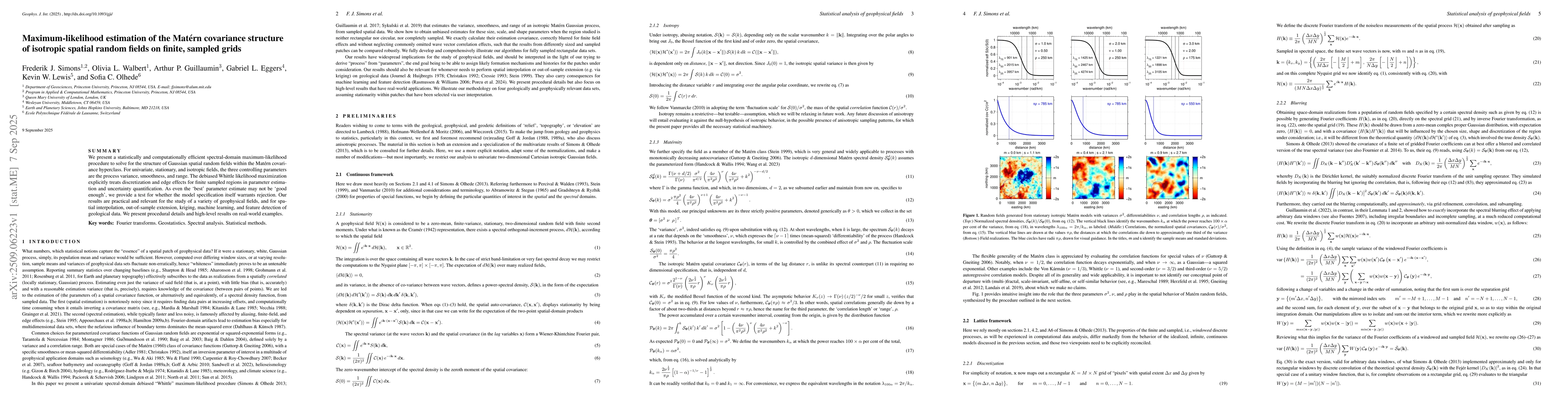
We present a statistically and computationally efficient spectral-domain maximum-likelihood procedure to solve for the structure of Gaussian spatial random fields within the Matern covariance hyperclass. For univariate, stationary, and isotropic fields, the three controlling parameters are the process variance, smoothness, and range. The debiased Whittle likelihood maximization explicitly treats discretization and edge effects for finite sampled regions in parameter estimation and uncertainty quantification. As even the best parameter estimate may not be good enough, we provide a test for whether the model specification itself warrants rejection. Our results are practical and relevant for the study of a variety of geophysical fields, and for spatial interpolation, out-of-sample extension, kriging, machine learning, and feature detection of geological data. We present procedural details and high-level results on real-world examples.
Key Findings, in focus
Seven facets of this paper, analysed and brought into focus by AI.
This research provides a reliable framework for spatial data analysis in geophysics and geology, enabling better interpretation of natural phenomena and supporting data-driven decision-making.
- Accurate parameter recovery across diverse spatial datasets
- Robust uncertainty quantification with quantifiable model errors
- Effective model testing through residual analysis and Q-Q plots
This research provides a reliable framework for spatial data analysis in geophysics and geology, enabling better interpretation of natural phenomena and supporting data-driven decision-making.
Development of an efficient algorithm for parameter estimation in Matérn processes with realistic sampling scenarios
Combines rigorous statistical modeling with practical applications, offering a novel approach to spatial data analysis with quantifiable uncertainties and model validation
- Dependence on regular sampling grids
- Potential challenges with highly anisotropic or non-stationary data
- Exploring irregular sampling patterns
- Integration with non-Gaussian models and machine learning techniques
Discussion 0