Quick Answers
What methodology did the authors use?
The research employs a combination of vehicle tracking, camera-to-satellite homography rectification, and YOLO11 object detection to analyze traffic camera footage and measure braking behavior. The pipeline uses MAGSAC++ for homography estimation, converts detections to a rectified coordinate system, and stores data in a ClickHouse database. More in Methodology →
What are the key results?
Braking events peaked at 57.5 per hour at the higher-volume intersection around 4 PM and 15.5 per hour at the second intersection around 10 AM. — Most braking events initiated upstream, with mild/moderate braking occurring 30-45+ meters from the stop bar and severe braking concentrated in high-activity lanes. More in Key Results →
Why is this work significant?
This system provides a scalable, cost-effective solution for monitoring braking behavior without specialized hardware, supporting proactive traffic management, crash mitigation, and data-driven safety analysis. More in Significance →
What are the main limitations?
Depends on existing traffic camera infrastructure — Requires accurate timestamp extraction from video frames More in Limitations →
Abstract
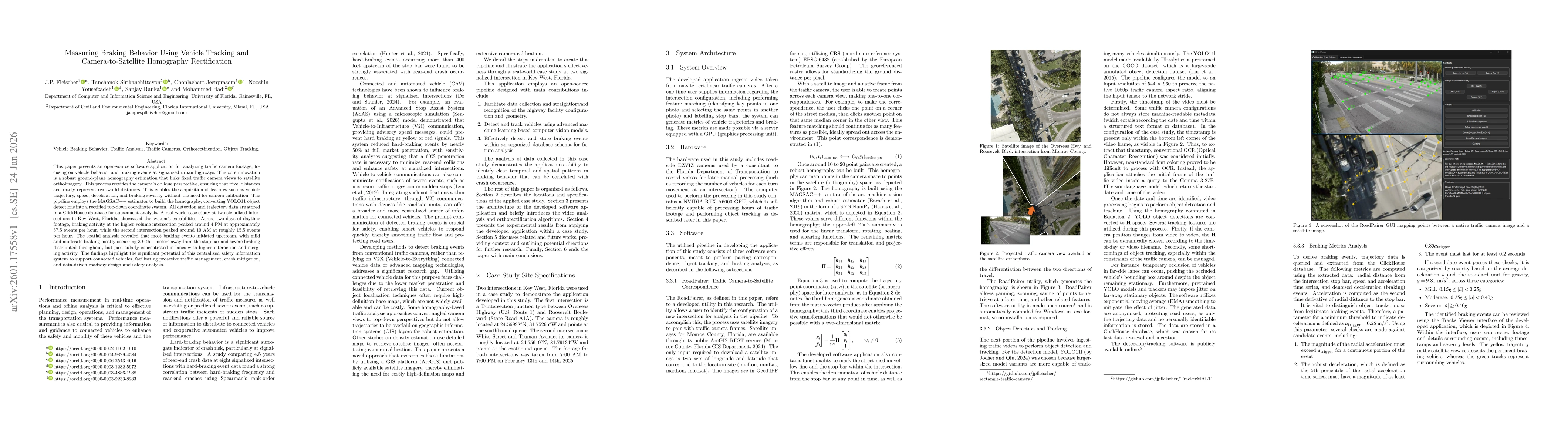
This paper presents an open-source software application for analyzing traffic camera footage, focusing on vehicle behavior and braking events at signalized urban highways. The core innovation is a robust ground-plane homography estimation that links fixed traffic camera views to satellite orthoimagery. This process rectifies the camera's oblique perspective, ensuring that pixel distances accurately represent real-world distances. This enables the acquisition of features such as vehicle trajectory, speed, deceleration, and braking severity without the need for camera calibration. The pipeline employs the MAGSAC++ estimator to build the homography, converting YOLO11 object detections into a rectified top-down coordinate system. All detection and trajectory data are stored in a ClickHouse database for subsequent analysis. A real-world case study at two signalized intersections in Key West, Florida, showcased the system's capabilities. Across two days of daytime footage, braking activity at the higher-volume intersection peaked around 4 PM at approximately 57.5 events per hour, while the second intersection peaked around 10 AM at roughly 15.5 events per hour. The spatial analysis revealed that most braking events initiated upstream, with mild and moderate braking mostly occurring 30 to 45+ meters away from the stop bar and severe braking distributed throughout, but particularly concentrated in lanes with higher interaction and merging activity. The findings highlight the significant potential of this centralized safety information system to support connected vehicles, facilitating proactive traffic management, crash mitigation, and data-driven roadway design and safety analysis.
AI Key Findings
Generated Jan 27, 2026
Methodology — What approach did the authors take?
The research employs a combination of vehicle tracking, camera-to-satellite homography rectification, and YOLO11 object detection to analyze traffic camera footage and measure braking behavior. The pipeline uses MAGSAC++ for homography estimation, converts detections to a rectified coordinate system, and stores data in a ClickHouse database.
Key Results — What are the main findings?
- Braking events peaked at 57.5 per hour at the higher-volume intersection around 4 PM and 15.5 per hour at the second intersection around 10 AM.
- Most braking events initiated upstream, with mild/moderate braking occurring 30-45+ meters from the stop bar and severe braking concentrated in high-activity lanes.
- Average braking deceleration showed consistent median values, but higher extremal values occurred during peak traffic periods.
Significance — Why does this research matter?
This system provides a scalable, cost-effective solution for monitoring braking behavior without specialized hardware, supporting proactive traffic management, crash mitigation, and data-driven safety analysis.
Technical Contribution — What is the technical contribution?
Development of an open-source software tool combining homography rectification, YOLO11 tracking, and ClickHouse data storage for analyzing braking behavior from traffic footage.
Novelty — What is new about this work?
First to integrate camera-to-satellite homography rectification with real-time object detection for accurate braking event measurement without camera calibration.
Limitations — What are the limitations of this study?
- Depends on existing traffic camera infrastructure
- Requires accurate timestamp extraction from video frames
- Limited to areas with satellite imagery and georeferenced data
Future Work — What did the authors propose for future work?
- Improving trajectory robustness under occlusions and adverse weather
- Extending framework to multi-camera fusion for corridor/network-level analysis
- Integrating additional surrogate safety measures like time-to-collision
Paper Details
How to Cite This Paper
@article{jeenprasom2026measuring,
title = {Measuring Braking Behavior Using Vehicle Tracking and Camera-to-Satellite Homography Rectification},
author = {Jeenprasom, Chonlachart and Fleischer, J. P. and Hadi, Mohammed and others},
year = {2026},
eprint = {2601.17558},
archivePrefix = {arXiv},
primaryClass = {cs.SE},
}
Jeenprasom, C., Fleischer, J., Hadi, M., Yousefzadeh, N., Ranka, S., & Sirikanchittavon, T. (2026). Measuring Braking Behavior Using Vehicle Tracking and Camera-to-Satellite Homography Rectification. arXiv. https://arxiv.org/abs/2601.17558
Jeenprasom, Chonlachart, et al. "Measuring Braking Behavior Using Vehicle Tracking and Camera-to-Satellite Homography Rectification." arXiv, 2026, arxiv.org/abs/2601.17558.
PDF Preview
Similar Papers
Found 4 papersMulti-target multi-camera vehicle tracking using transformer-based camera link model and spatial-temporal information
Hsiang-Wei Huang, Cheng-Yen Yang, Jenq-Neng Hwang
Multiple-Kernel Based Vehicle Tracking Using 3D Deformable Model and Camera Self-Calibration
An optical flow approach to tracking ship track behavior using GOES-R satellite imagery
Kelsie M. Larson, Lyndsay Shand, Andrea Staid et al.
Comments (0)