Measuring city-scale green infrastructure drawdown dynamics using internet-connected sensors in Detroit
Publication
Metrics
AI Quick Summary
This study deploys an internet-connected sensor network in Detroit to measure real-time green infrastructure (GI) water levels, analyzing GI drawdown dynamics across 14 sites. Key factors influencing GI performance include depth to groundwater, imperviousness, and drainage area ratios, highlighting data-driven strategies for GI design.
Paper Preview
Abstract
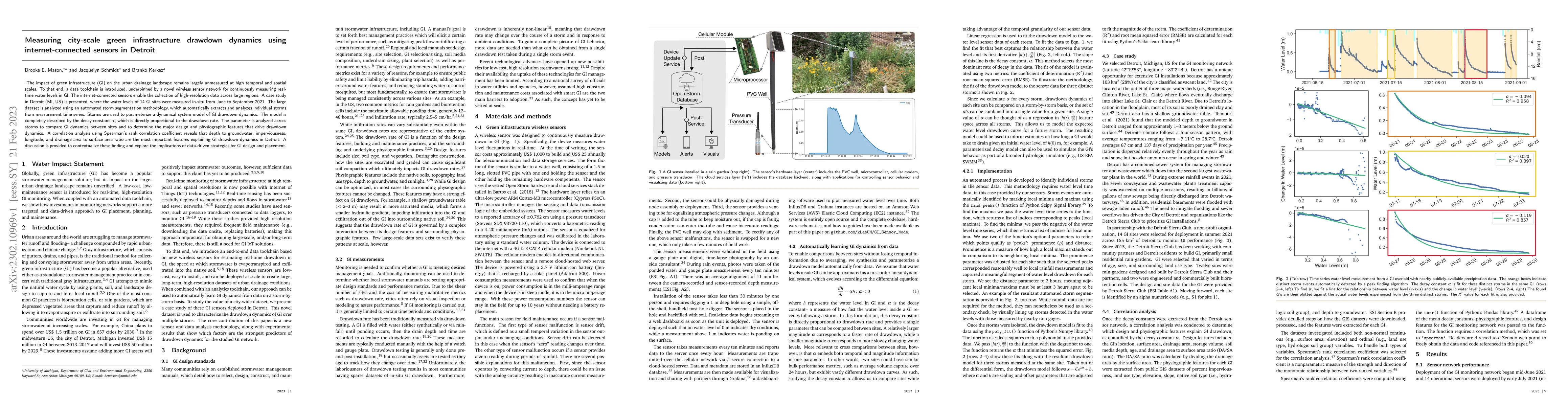
The impact of green infrastructure (GI) on the urban drainage landscape remains largely unmeasured at high temporal and spatial scales. To that end, a data toolchain is introduced, underpinned by a novel wireless sensor network for continuously measuring real-time water levels in GI. The internet-connected sensors enable the collection of high-resolution data across large regions. A case study in Detroit (MI, US) is presented, where the water levels of 14 GI sites were measured in-situ from June to September 2021. The large dataset is analyzed using an automated storm segmentation methodology, which automatically extracts and analyzes individual storms from measurement time series. Storms are used to parameterize a dynamical system model of GI drawdown dynamics. The model is completely described by the decay constant {\alpha}, which is directly proportional to the drawdown rate. The parameter is analyzed across storms to compare GI dynamics between sites and to determine the major design and physiographic features that drive drawdown dynamics. A correlation analysis using Spearman's rank correlation coefficient reveals that depth to groundwater, imperviousness, longitude, and drainage area to surface area ratio are the most important features explaining GI drawdown dynamics in Detroit. A discussion is provided to contextualize these finding and explore the implications of data-driven strategies for GI design and placement.
AI Key Findings
Get AI-generated insights about this paper's methodology, results, significance, and more — seven facets brought into focus.
Impact
Paper Details
Authors
PDF Preview
Key Terms
Citation Network
Current paper (gray), citations (green), references (blue)
Display is limited for performance on very large graphs.
Discussion 0