Methane Emissions from Super-emitting Coal Mines in Australia quantified using TROPOMI Satellite Observations
Publication
Metrics
AI Quick Summary
This study uses TROPOMI satellite data to quantify methane emissions from six coal mines in Queensland, Australia, estimating a total emission of 570±98 Gg a-1 in 2018-2019. The findings highlight significant discrepancies between satellite-based estimates and reported emissions, particularly from the Hail Creek mine.
Paper Preview
Abstract
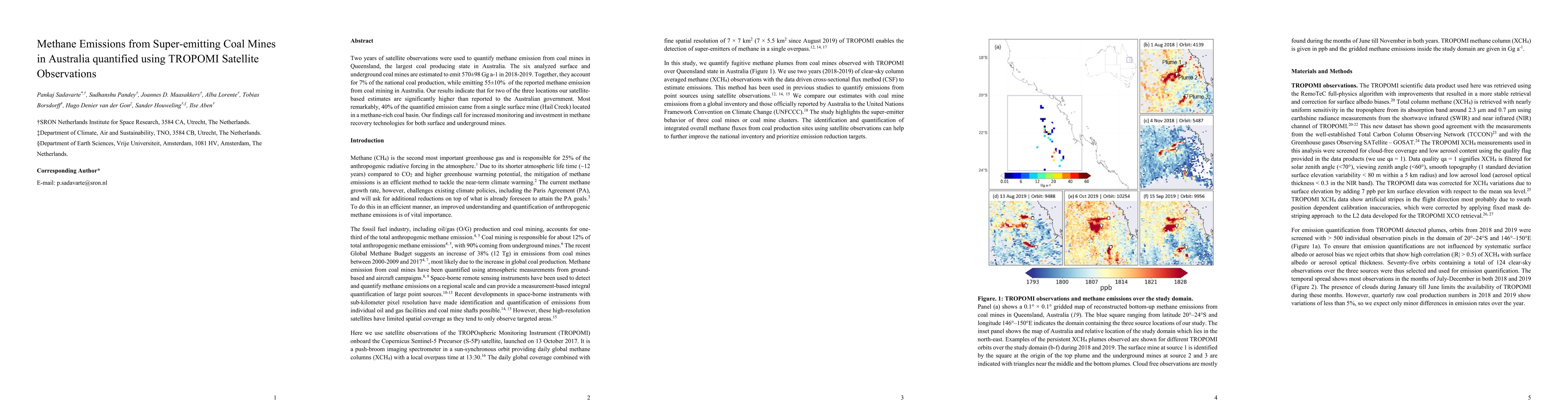
Two years of satellite observations were used to quantify methane emission from coal mines in Queensland, the largest coal-producing state in Australia. The six analyzed surface and underground coal mines are estimated to emit 570+/-98 Gg a-1 in 2018-2019. Together, they account for 7% of the national coal production, while emitting 55+/-10% of the reported methane emission from coal mining in Australia. Our results indicate that for two of the three locations our satellite-based estimates are significantly higher than reported to the Australian government. Most remarkably, 40% of the quantified emission came from a single surface mine (Hail Creek) located in a methane-rich coal basin. Our findings call for increased monitoring and investment in methane recovery technologies for both surface and underground mines.
AI Key Findings
Get AI-generated insights about this paper's methodology, results, significance, and more — seven facets brought into focus.
Impact
Paper Details
Authors
PDF Preview
Key Terms
Citation Network
Current paper (gray), citations (green), references (blue)
Display is limited for performance on very large graphs.
Discussion 0