Summary

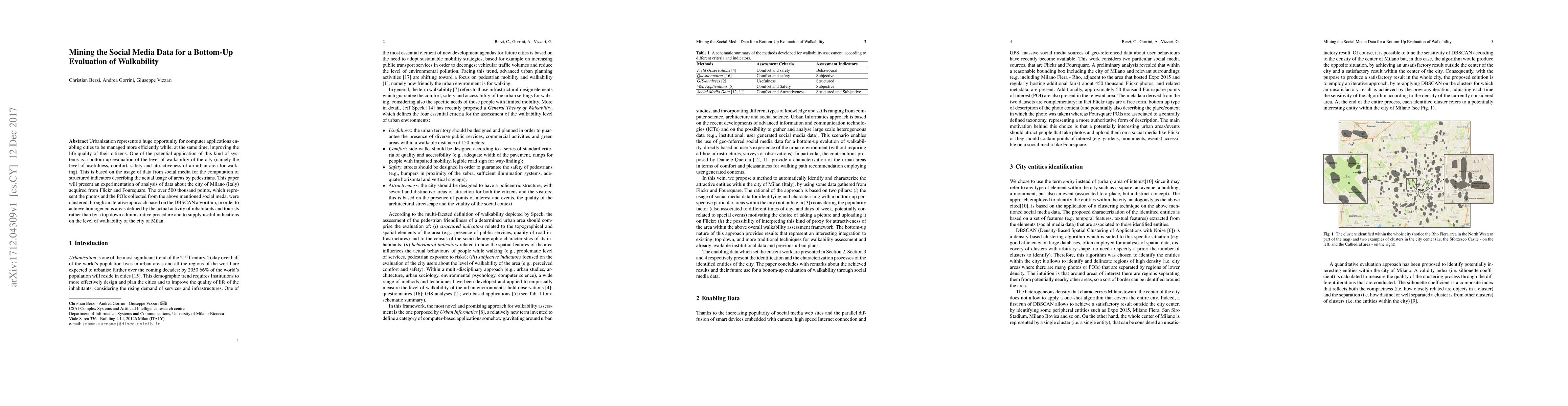
Urbanization represents a huge opportunity for computer applications enabling cities to be managed more efficiently while, at the same time, improving the life quality of their citizens. One of the potential application of this kind of systems is a bottom-up evaluation of the level of walkability of the city (namely the level of usefulness, comfort, safety and attractiveness of an urban area for walking). This is based on the usage of data from social media for the computation of structured indicators describing the actual usage of areas by pedestrians. This paper will present an experimentation of analysis of data about the city of Milano (Italy) acquired from Flickr and Foursquare. The over 500 thousand points, which represent the photos and the POIs collected from the above mentioned social meda, were clustered through an iterative approach based on the DBSCAN algorithm, in order to achieve homogeneous areas defined by the actual activity of inhabitants and tourists rather than by a top down administrative procedure and to supply useful indications on the level of walkability of the city of Milan.

AI Key Findings

Get AI-generated insights about this paper's methodology, results, and significance.

Paper Details

PDF Preview

Download PDF

Key Terms

life (0.138)
procedure (0.116)
data (0.107)
based (0.102)
order (0.074)
analysis (0.074)
approach (0.072)
present (0.068)

Citation Network

Current paper (gray), citations (green), references (blue)

Current Paper
Citations
References
Click to view
Title Authors Year Actions
From intangible to tangible: The role of big data and machine learning in walkability studies
Jun Yang, Pia Fricker, Alexander Jung
2024
View Paper
Using open data and deep learning to explore walkability in Shenzhen, China
Xuan He, Sylvia Y. He
2023
View Paper
Research Framework: Tourist Walkability and Sustainable Tourism Impact on Residents
M. Liow
2022
View Paper
Social and Active Inclusion of the Elderly in the City Through Affective Walkability
S. Bandini, F. Gasparini
2021
View Paper
Eliciting cities points of interest from people movements and suggesting effective itineraries
Claudia Cavallaro, Gabriella Verga, E. Tramontana, O. Muscato
2020
View Paper
Recursive Data Clustering through Finding Vague Solutions
Domenico Monaco
2019
View Paper
The more walkable, the more livable? -- can urban attractiveness improve urban vitality?
Yang Liang, D. D’Uva, A. Scandiffio, Andrea Rolando
2022
View Paper
User Assistance for Predicting the Availability of Bikes at Bike Stations
Claudia Cavallaro, E. Tramontana
2021
View Paper
Geospatial Technologies for Urban Health
Yongmei Lu, E. Delmelle
2020
View Paper
Suggesting Just Enough (Un)Crowded Routes and Destinations
Claudia Cavallaro, Gabriella Verga, E. Tramontana, O. Muscato
2020
View Paper
A Customised Assessment Tool Based on Cellular Automata for the Visit-Ability of an Urban Environment
Irene Georgiadi, G. Trunfio, I. Georgoudas, G. Sirakoulis
2020
View Paper
Incorporating Online Survey and Social Media Data into a GIS Analysis for Measuring Walkability
Xuan Zhang, Lan Mu
2019
View Paper
Walkability Assessment for the Elderly Through Simulations: The LONGEVICITY Project
S. Bandini, L. Crociani, A. Gorrini, K. Nishinari, Giuseppe Vizzari
2018
View Paper
Elderly Walkability Index through GIS: Towards Advanced AI-based Simulation Models
A. Gorrini, S. Bandini
2018
View Paper

Comments (0)

This website uses cookies to ensure you get the best experience. Learn more