mmWave Radar-Based Non-Line-of-Sight Pedestrian Localization at T-Junctions Utilizing Road Layout Extraction via Camera
Publication
Metrics
AI Quick Summary
This research introduces a novel framework using mmWave radar and camera data to localize pedestrians in Non-Line-of-Sight (NLoS) urban environments, overcoming radar's 2D point cloud distortions and camera's lack of depth perception by integrating road layout information from camera imagery.
Paper Preview
Abstract
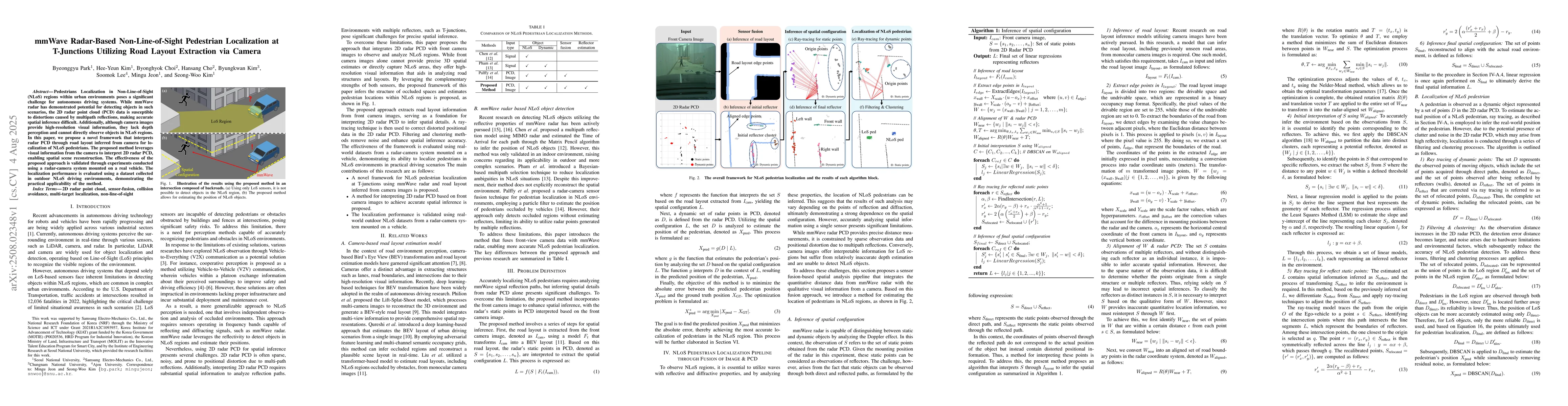
Pedestrians Localization in Non-Line-of-Sight (NLoS) regions within urban environments poses a significant challenge for autonomous driving systems. While mmWave radar has demonstrated potential for detecting objects in such scenarios, the 2D radar point cloud (PCD) data is susceptible to distortions caused by multipath reflections, making accurate spatial inference difficult. Additionally, although camera images provide high-resolution visual information, they lack depth perception and cannot directly observe objects in NLoS regions. In this paper, we propose a novel framework that interprets radar PCD through road layout inferred from camera for localization of NLoS pedestrians. The proposed method leverages visual information from the camera to interpret 2D radar PCD, enabling spatial scene reconstruction. The effectiveness of the proposed approach is validated through experiments conducted using a radar-camera system mounted on a real vehicle. The localization performance is evaluated using a dataset collected in outdoor NLoS driving environments, demonstrating the practical applicability of the method.
AI Key Findings
Get AI-generated insights about this paper's methodology, results, significance, and more — seven facets brought into focus.
Discussion 0