Publication

Published: May 12, 2026
Categories: cs.CV

Metrics

Source: ArXiv

Quick Actions

View PDF

AI Quick Summary

The paper presents a lightweight method to convert monocular UAV video of road scenes into a metric bird’s-eye view by using visible road geometry to estimate a road-plane homography, enabling BEV vehicle trajectories and 3D cuboids for traffic analysis. It demonstrates the approach on UAVDT data, revealing that road-geometry calibration can enable camera-like analytics from UAV footage but is sensitive to far-field errors, currently relies on manual validation, and assumes a single road plane.

Quick Answers

What is "Mobile Traffic Camera Calibration from Road Geometry for UAV-Based Traffic Surveillance" about?

The paper presents a lightweight method to convert monocular UAV video of road scenes into a metric bird’s-eye view by using visible road geometry to estimate a road-plane homography, enabling BEV vehicle trajectories and 3D cuboids for traffic analysis. It demonstrates the approach on UAVDT data, revealing that road-geometry calibration can enable camera-like analytics from UAV footage but is sensitive to far-field errors, currently relies on manual validation, and assumes a single road plane.

What methodology did the authors use?

A lightweight calibration pipeline that estimates a road-plane homography from visible road geometry (lane markings, borders, crosswalks) in monocular oblique UAV video, then projects vehicle observations to a local metric BEV to produce trajectories, headings, speeds, and dynamic 3D cuboids on the road plane; includes a human-in-the-loop workflow for validation/correction and evaluates on UAVDT sequence M1401 to isolate calibration/geometric reconstruction... More in Methodology →

What are the key results?

On UAVDT sequence M1401 (40 frames, 632 metric cuboid instances across 23 tracks), the pipeline produced BEV trajectories and synchronized 3D cuboid visualizations, demonstrating interpretable traffic-camera-style analytics from monocular UAV footage. — Calibration-based BEV projection reduced reliance on full 3D reconstruction, enabling efficient estimation of vehicle direction, approximate speed, and road-plane cuboids for traffic analysis. More in Key Results →

Why is this work significant?

Demonstrates a practical, deployable approach to transform monocular UAV traffic video into BEV analytics suitable for traffic surveillance and digital-twin applications, bridging UAV flexibility with interpretable road-side analytics. More in Significance →

What are the main limitations?

Homography sensitivity to calibration quality; weak or occluded lane markings and ambiguous road regions degrade accuracy. — Single-plane road assumption restricts performance on non-planar or curved road segments. More in Limitations →

Paper Preview

Abstract

Unmanned aerial vehicles (UAVs) can provide flexible traffic surveillance where fixed roadside cameras are unavailable, costly, or impractical. However, raw UAV video is difficult to use for traffic analytics because vehicle motion is observed in perspective image coordinates rather than in a stable metric road coordinate system. This paper presents a lightweight pipeline for converting monocular oblique UAV traffic video into a local metric bird's-eye-view (BEV) representation. Visible road geometry, including lane markings, road borders, and crosswalks, is used to estimate a road-plane homography from image coordinates to metric ground-plane coordinates. Vehicle observations from dataset annotations or detectors are then projected to BEV using estimated ground contact points. The resulting trajectories support estimation of vehicle direction, speed, heading, and dynamic 3D cuboids on the road plane. We evaluate the pipeline on UAVDT using ground-truth annotations to isolate calibration and geometric reconstruction from detector and tracker errors. For sequence M1401, 40 sampled frames from img000001-img000196 produce 632 metric cuboid instances across 23 tracks. Results show that road-geometry calibration can transform monocular UAV footage into interpretable traffic-camera-style analytics, including BEV tracks and synchronized 3D cuboid visualizations. They also reveal key limitations: far-field vehicles are sensitive to homography errors, manual validation is currently more reliable than fully automatic calibration, and the single-plane assumption limits performance in non-planar or ambiguous road regions. The proposed pipeline provides a practical foundation for deployable UAV traffic cameras and future real-time traffic digital-twin systems.
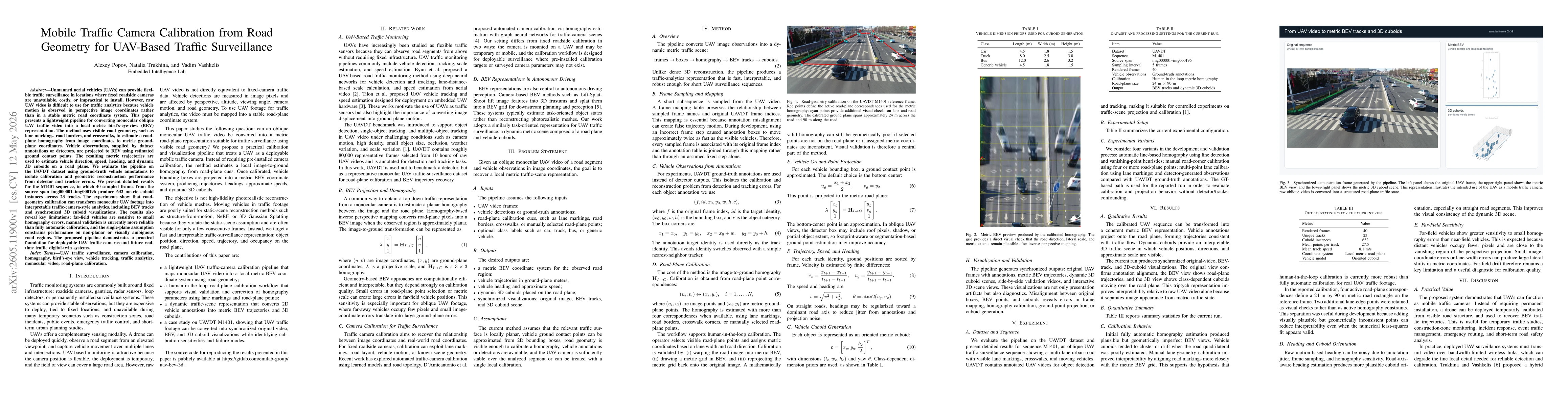
AI Key Findings

Generated May 13, 2026

Methodology — What approach did the authors take?

A lightweight calibration pipeline that estimates a road-plane homography from visible road geometry (lane markings, borders, crosswalks) in monocular oblique UAV video, then projects vehicle observations to a local metric BEV to produce trajectories, headings, speeds, and dynamic 3D cuboids on the road plane; includes a human-in-the-loop workflow for validation/correction and evaluates on UAVDT sequence M1401 to isolate calibration/geometric reconstruction from detector errors.

Key Results — What are the main findings?

  • On UAVDT sequence M1401 (40 frames, 632 metric cuboid instances across 23 tracks), the pipeline produced BEV trajectories and synchronized 3D cuboid visualizations, demonstrating interpretable traffic-camera-style analytics from monocular UAV footage.
  • Calibration-based BEV projection reduced reliance on full 3D reconstruction, enabling efficient estimation of vehicle direction, approximate speed, and road-plane cuboids for traffic analysis.
  • Far-field vehicles remained sensitive to small homography errors, indicating limitations in distant vehicle accuracy.
  • Manual validation of calibration parameters provided more reliability than fully automatic calibration in current setup.

Significance — Why does this research matter?

Demonstrates a practical, deployable approach to transform monocular UAV traffic video into BEV analytics suitable for traffic surveillance and digital-twin applications, bridging UAV flexibility with interpretable road-side analytics.

Technical Contribution — What is the technical contribution?

A practical pipeline that calibrates oblique monocular UAV footage to a local metric road plane using road geometry, enabling BEV trajectories and dynamic 3D cuboids for traffic analytics, with a human-in-the-loop validation workflow and a case study on UAVDT M1401.

Novelty — What is new about this work?

Introduces a lightweight, camera-calibration-first approach for UAV traffic surveillance that yields BEV-level vehicle trajectories and 3D cuboids from monocular videos, diverging from full 3D reconstruction and enabling deployable, traffic-focused analytics.

Limitations — What are the limitations of this study?

  • Homography sensitivity to calibration quality; weak or occluded lane markings and ambiguous road regions degrade accuracy.
  • Single-plane road assumption restricts performance on non-planar or curved road segments.
  • Use of approximate ground-contact points and class-level cuboid priors limits precise vehicle sizing, especially for non-car classes.
  • Far-field vehicle accuracy is challenged due to small image footprint and projection errors.

Future Work — What did the authors propose for future work?

  • Automatic lane-level calibration and multi-frame homography stabilization.
  • Road-axis and lane-centerline extraction to strengthen calibration cues.
  • Robust ground-contact-point estimation and tighter integration with detectors/trainers for real-time processing.
  • Real-time processing, multi-drone fusion, and georeferenced coordinates using GPS/IMU data.
  • Uncertainty estimation for far-field vehicle detections and curved-road/multi-plane road modeling.

Paper Details

Paper ID: 2605.11900
Categories:
cs.CV

How to Cite This Paper

BibTeX
@article{popov2026mobile,
  title         = {Mobile Traffic Camera Calibration from Road Geometry for UAV-Based Traffic Surveillance},
  author        = {Popov, Alexey and Trukhina, Natalia and Vashkelis, Vadim},
  year          = {2026},
  eprint        = {2605.11900},
  archivePrefix = {arXiv},
  primaryClass  = {cs.CV},
}
APA 7
Popov, A., Trukhina, N., & Vashkelis, V. (2026). Mobile Traffic Camera Calibration from Road Geometry for UAV-Based Traffic Surveillance. arXiv. https://arxiv.org/abs/2605.11900
MLA 9
Popov, Alexey, et al. "Mobile Traffic Camera Calibration from Road Geometry for UAV-Based Traffic Surveillance." arXiv, 2026, arxiv.org/abs/2605.11900.

Similar Papers

Found 4 papers

Comments (0)

This website uses cookies to ensure you get the best experience. Learn more