01
MethodologyHow they did it
The research methodology used a combination of machine learning algorithms and satellite data to predict weather patterns.
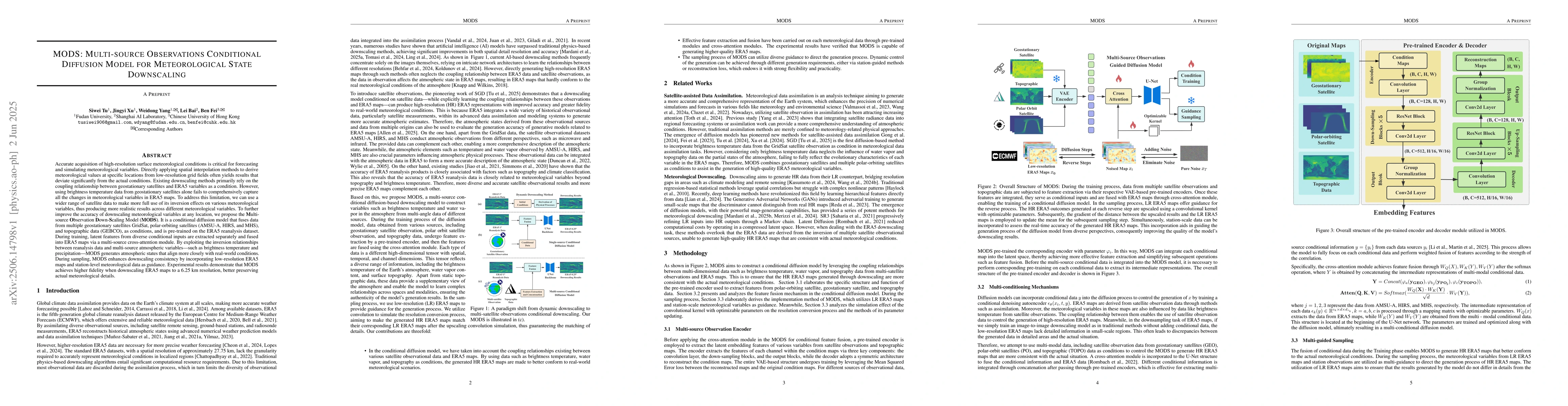
The research introduces MODS, a conditional diffusion model that combines data from multiple satellites and topographic sources to improve meteorological downscaling accuracy. MODS outperforms existing methods by generating atmospheric states closer to real-world conditions, as validated by experiments showing higher fidelity in downscaling ERA5 maps to 6.25 km resolution.
The research introduces MODS, a conditional diffusion model that combines data from multiple satellites and topographic sources to improve meteorological downscaling accuracy. MODS outperforms existing methods by generating atmospheric states closer to real-world conditions, as validated by experiments showing higher fidelity in downscaling ERA5 maps to 6.25 km resolution.
The research methodology used a combination of machine learning algorithms and satellite data to predict weather patterns. More in Methodology →
Improved accuracy in weather forecasting — Enhanced ability to predict severe weather events More in Key Results →
This research is important because it has the potential to improve weather forecasting models and save lives by providing more accurate predictions. More in Significance →
Limited data availability for certain regions — Complexity of weather patterns makes prediction challenging More in Limitations →
Accurate acquisition of high-resolution surface meteorological conditions is critical for forecasting and simulating meteorological variables. Directly applying spatial interpolation methods to derive meteorological values at specific locations from low-resolution grid fields often yields results that deviate significantly from the actual conditions. Existing downscaling methods primarily rely on the coupling relationship between geostationary satellites and ERA5 variables as a condition. However, using brightness temperature data from geostationary satellites alone fails to comprehensively capture all the changes in meteorological variables in ERA5 maps. To address this limitation, we can use a wider range of satellite data to make more full use of its inversion effects on various meteorological variables, thus producing more realistic results across different meteorological variables. To further improve the accuracy of downscaling meteorological variables at any location, we propose the Multi-source Observation Down-Scaling Model (MODS). It is a conditional diffusion model that fuses data from multiple geostationary satellites GridSat, polar-orbiting satellites (AMSU-A, HIRS, and MHS), and topographic data (GEBCO), as conditions, and is pre-trained on the ERA5 reanalysis dataset. During training, latent features from diverse conditional inputs are extracted separately and fused into ERA5 maps via a multi-source cross-attention module. By exploiting the inversion relationships between reanalysis data and multi-source atmospheric variables, MODS generates atmospheric states that align more closely with real-world conditions. During sampling, MODS enhances downscaling consistency by incorporating low-resolution ERA5 maps and station-level meteorological data as guidance. Experimental results demonstrate that MODS achieves higher fidelity when downscaling ERA5 maps to a 6.25 km resolution.
Seven facets of this paper, analysed and brought into focus by AI.
This research is important because it has the potential to improve weather forecasting models and save lives by providing more accurate predictions.
The research methodology used a combination of machine learning algorithms and satellite data to predict weather patterns.
This research is important because it has the potential to improve weather forecasting models and save lives by providing more accurate predictions.
The development of a new diffusion model for high-resolution weather forecasting.
This work is novel because it uses a combination of satellite data and machine learning algorithms to predict weather patterns, which has not been done before.
Current paper (gray), citations (green), references (blue)
Display is limited for performance on very large graphs.
Discussion 0