Publication
Metrics
AI Quick Summary
This paper introduces a novel continuous 3D loss function for monocular depth prediction, which treats point clouds as continuous objects to improve accuracy over sparse LIDAR measurements. The proposed loss enhances depth prediction accuracy and 3D geometric consistency across several state-of-the-art monocular depth prediction methods.
Paper Preview
Abstract
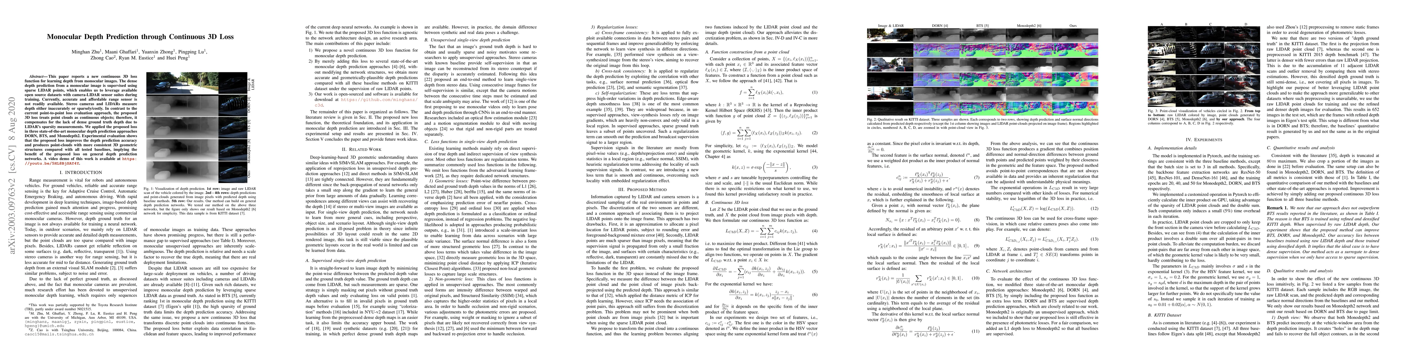
This paper reports a new continuous 3D loss function for learning depth from monocular images. The dense depth prediction from a monocular image is supervised using sparse LIDAR points, which enables us to leverage available open source datasets with camera-LIDAR sensor suites during training. Currently, accurate and affordable range sensor is not readily available. Stereo cameras and LIDARs measure depth either inaccurately or sparsely/costly. In contrast to the current point-to-point loss evaluation approach, the proposed 3D loss treats point clouds as continuous objects; therefore, it compensates for the lack of dense ground truth depth due to LIDAR's sparsity measurements. We applied the proposed loss in three state-of-the-art monocular depth prediction approaches DORN, BTS, and Monodepth2. Experimental evaluation shows that the proposed loss improves the depth prediction accuracy and produces point-clouds with more consistent 3D geometric structures compared with all tested baselines, implying the benefit of the proposed loss on general depth prediction networks. A video demo of this work is available at https://youtu.be/5HL8BjSAY4Y.
AI Key Findings
Get AI-generated insights about this paper's methodology, results, significance, and more — seven facets brought into focus.
Impact
Paper Details
Authors
PDF Preview
Key Terms
Citation Network
Current paper (gray), citations (green), references (blue)
Display is limited for performance on very large graphs.
Discussion 0