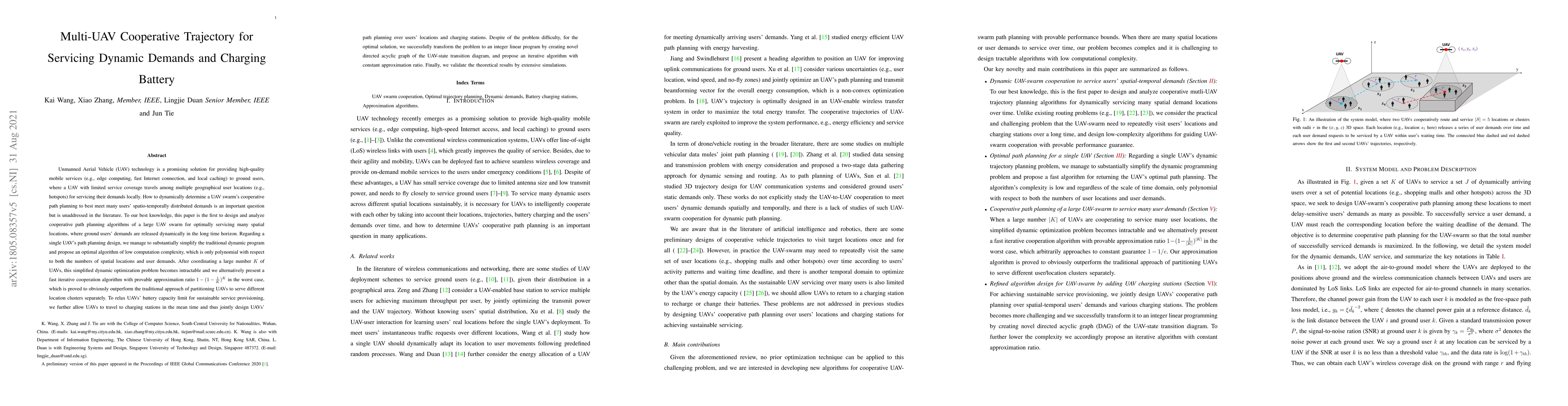
Multi-UAV Cooperative Trajectory for Servicing Dynamic Demands and Charging Battery
Publication
Metrics
AI Quick Summary
This paper introduces novel algorithms for optimally coordinating a large UAV swarm to serve dynamically changing user demands, simplifying traditional path planning methods for single UAVs to reduce computational complexity. For multiple UAVs, it presents an iterative cooperation algorithm with a provable approximation ratio, outperforming traditional partitioning methods. Additionally, it addresses UAV battery limitations by integrating charging station visits into path planning, transforming the problem into an integer linear program with a constant approximation ratio.
Paper Preview
Abstract
Unmanned Aerial Vehicle (UAV) technology is a promising solution for providing high-quality mobile services to ground users, where a UAV with limited service coverage travels among multiple geographical user locations (e.g., hotspots) for servicing their demands locally. How to dynamically determine a UAV swarm's cooperative path planning to best meet many users' spatio-temporally distributed demands is an important question but is unaddressed in the literature. To our best knowledge, this paper is the first to design and analyze cooperative path planning algorithms of a large UAV swarm for optimally servicing many spatial locations, where ground users' demands are released dynamically in the long time horizon. Regarding a single UAV's path planning design, we manage to substantially simplify the traditional dynamic program and propose an optimal algorithm of low computation complexity, which is only polynomial with respect to both the numbers of spatial locations and user demands. After coordinating a large number $K$ of UAVs, this simplified dynamic optimization problem becomes intractable and we alternatively present a fast iterative cooperation algorithm with provable approximation ratio $1-(1-\frac{1}{K})^{K}$ in the worst case, which is proved to obviously outperform the traditional approach of partitioning UAVs to serve different location clusters separately. To relax UAVs' battery capacity limit for sustainable service provisioning, we further allow UAVs to travel to charging stations in the mean time and thus jointly design UAVs' path planning over users' locations and charging stations. Despite of the problem difficulty, for the optimal solution, we successfully transform the problem to an integer linear program by creating novel directed acyclic graph of the UAV-state transition diagram, and propose an iterative algorithm with constant approximation ratio.
AI Key Findings
Get AI-generated insights about this paper's methodology, results, significance, and more — seven facets brought into focus.
Impact
Paper Details
PDF Preview
Key Terms
Citation Network
Current paper (gray), citations (green), references (blue)
Display is limited for performance on very large graphs.
Discussion 0