Quick Summary:

The MultiEarth 2023 Workshop aims to advance multimodal learning for Earth ecosystem monitoring using remote sensing data. It organizes challenges to benchmark techniques for tasks like deforestation estimation and forest fire detection in the Amazon rainforest.

Summary

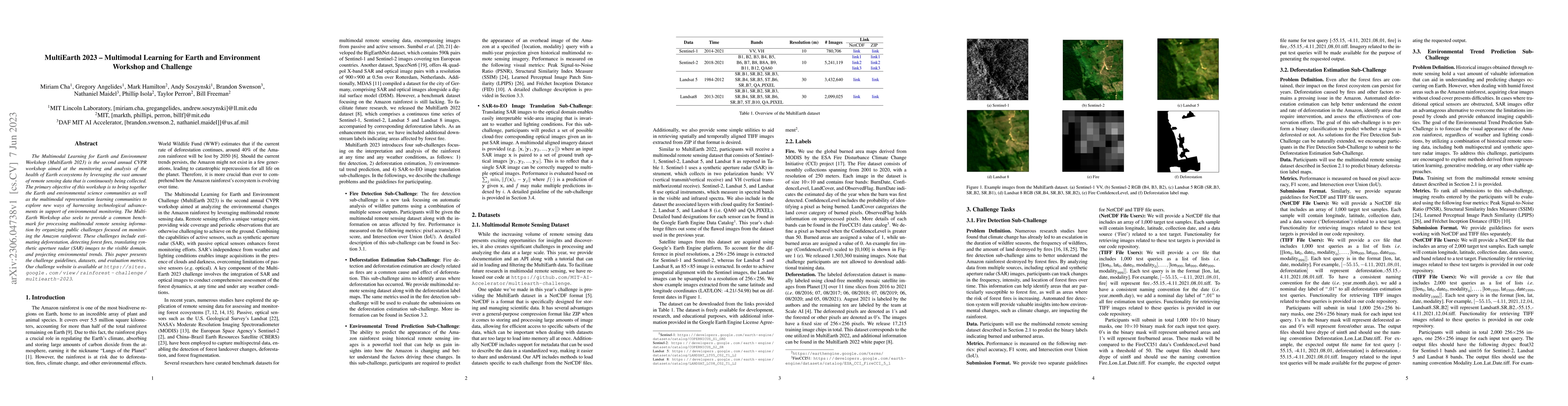
The Multimodal Learning for Earth and Environment Workshop (MultiEarth 2023) is the second annual CVPR workshop aimed at the monitoring and analysis of the health of Earth ecosystems by leveraging the vast amount of remote sensing data that is continuously being collected. The primary objective of this workshop is to bring together the Earth and environmental science communities as well as the multimodal representation learning communities to explore new ways of harnessing technological advancements in support of environmental monitoring. The MultiEarth Workshop also seeks to provide a common benchmark for processing multimodal remote sensing information by organizing public challenges focused on monitoring the Amazon rainforest. These challenges include estimating deforestation, detecting forest fires, translating synthetic aperture radar (SAR) images to the visible domain, and projecting environmental trends. This paper presents the challenge guidelines, datasets, and evaluation metrics. Our challenge website is available at https://sites.google.com/view/rainforest-challenge/multiearth-2023.

AI Key Findings

Get AI-generated insights about this paper's methodology, results, and significance.

Paper Details

PDF Preview

Download PDF

Key Terms

multimodal (0.259)
environmental (0.235)
remote sensing (0.233)
earth (0.230)
monitoring (0.230)
communities (0.212)
remote (0.200)
challenge (0.194)
sensing (0.178)
challenges (0.150)
representation learning (0.134)
forest (0.131)
radar (0.131)
advancements (0.131)
bring (0.127)
aimed (0.126)
aperture (0.126)
technological (0.124)
vast (0.124)
trends (0.118)

Citation Network

Current paper (gray), citations (green), references (blue)

Current Paper
Citations
References
Click to view
Title Authors Year Actions
Generating High-Resolution Labels Using a Low-Resolution Amazon Deforestation Dataset and Pseudo-Labeling Techniques
Dongoo Lee, Yeonju Choi
2025
View Paper
FLOGA: A Machine-Learning-Ready Dataset, a Benchmark, and a Novel Deep Learning Model for Burnt Area Mapping With Sentinel-2
Maria Sdraka, Alkinoos Dimakos, Alexandros Malounis, Zisoula Ntasiou, Konstantinos Karantzalos, Dimitrios Michail, I. Papoutsis
2023
View Paper
A Learning Strategy for Amazon Deforestation Estimations Using Multi-Modal Satellite Imagery
Dongoo Lee, Yeonju Choi
2023
View Paper
CVPR MultiEarth 2023 Deforestation Estimation Challenge: SpaceVision4Amazon
Sunita Arya, Manthira Moorthi Subbiah, D. Dhar
2023
View Paper
Rapid Deforestation and Burned Area Detection using Deep Multimodal Learning on Satellite Imagery
Gábor Fodor, Marcos V. Conde
2023
View Paper
1st Place Solution to MultiEarth 2023 Challenge on Multimodal SAR-to-EO Image Translation
Jin-gi Ju, Hyeon-cheol Noh, Min-Woo Kim, Dong-geol Choi
2023
View Paper
MultiEarth 2023 Deforestation Challenge - Team FOREVER
Seung-Myong Park, Dongoo Lee, Yeonju Choi, S. Moon
2023
View Paper
Common Practices and Taxonomy in Deep Multiview Fusion for Remote Sensing Applications
F. Mena, Diego Arenas, M. Nuske, A. Dengel
2022
View Paper
A Strategy Optimized Pix2pix Approach for SAR-to-Optical Image Translation Task
Fujian Cheng, Yashu Kang, Chun-Shih Chen, Kezhao Jiang
2022
View Paper
MultiEarth 2022 Deforestation Challenge - ForestGump
Dongoo Lee, Yeonju Choi
2022
View Paper
MultiEarth 2022 - The Champion Solution for the Matrix Completion Challenge via Multimodal Regression and Generation
Bo Peng, Hongcheng Liu, Hang Zhou, Yuchuan Gou, Jui-Hsin Lai
2022
View Paper
Explicit Haze & Cloud Removal for Global Land Cover Classification
Ziqi Gu, Patrick Ebel, Qiangqiang Yuan, Michael Schmitt, Xiao Xiang Zhu
View Paper

Comments (0)

This website uses cookies to ensure you get the best experience. Learn more