01
MethodologyHow they did it
This study uses a combination of network analysis techniques to examine pedestrian-scale connectivity in urban environments.
This study uses a combination of network analysis techniques to examine pedestrian-scale connectivity in urban environments. More in Methodology →
Pedestrian-scale connectivity is strongly correlated with land-use intensity and mix. — Betweenness centrality measures are relatively meaningless in contexts with low closeness centralities. More in Key Results →
Understanding pedestrian-scale connectivity is crucial for designing sustainable and accessible urban environments. More in Significance →
The study's focus on mixed-use high streets may not generalize to wider mixed-used districts. — Network decomposition can introduce artifacts in centrality measures. More in Limitations →
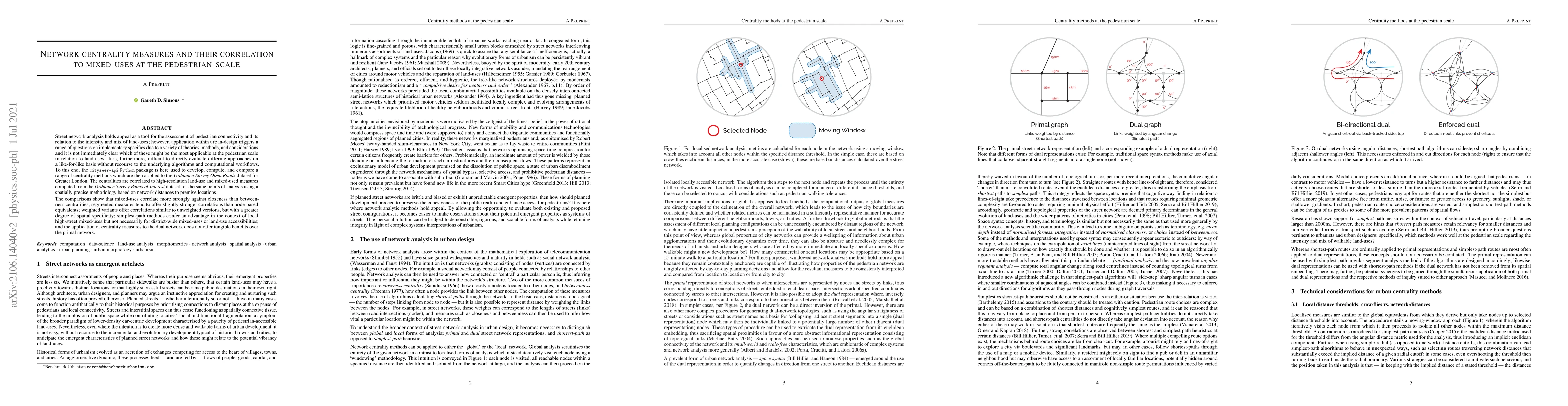
Street network analysis holds appeal as a tool for the assessment of pedestrian connectivity and its relation to the intensity and mix of land-uses; however, application within urban-design triggers a range of questions on implementary specifics due to a variety of theories, methods, and considerations and it is not immediately clear which of these might be the most applicable at the pedestrian scale in relation to land-uses. It is, furthermore, difficult to directly evaluate differing approaches on a like-for-like basis without recourse to the underlying algorithms and computational workflows. To this end, the cityseer-api Python package is here used to develop, compute, and compare a range of centrality methods which are then applied to the Ordnance Survey Open Roads dataset for Greater London. The centralities are correlated to high-resolution land-use and mixed-used measures computed from the Ordnance Survey Points of Interest dataset for the same points of analysis using a spatially precise methodology based on network distances to premise locations. The comparisons show that mixed-uses correlate more strongly against closeness than betweenness centralities; segmented measures tend to offer slightly stronger correlations than node-based equivalents; weighted variants offer correlations similar to unweighted versions, but with a greater degree of spatial specificity; simplest-path methods confer an advantage in the context of local high-street mixed-uses but not necessarily for district-wide mixed-uses or land-use accessibilities; and the application of centrality measures to the dual network does not offer tangible benefits over the primal network.
Seven facets of this paper, analysed and brought into focus by AI.
Understanding pedestrian-scale connectivity is crucial for designing sustainable and accessible urban environments.
This study uses a combination of network analysis techniques to examine pedestrian-scale connectivity in urban environments.
Understanding pedestrian-scale connectivity is crucial for designing sustainable and accessible urban environments.
This study contributes to our understanding of pedestrian-scale connectivity by examining its relationship with land-use intensity and mix.
The use of network decomposition to analyze pedestrian-scale connectivity is a novel approach in urban studies.
Current paper (gray), citations (green), references (blue)
Display is limited for performance on very large graphs.
Discussion 0