Normalizing and classifying shape indexes of cities by ideas from fractals
Publication
Metrics
AI Quick Summary
This paper normalizes and classifies urban shape indexes using fractal geometry principles to address scale dependence issues. It derives formulas to unify various shape indexes and reveals three levels of scaling, classifying shape indexes into three groups, thus enhancing the understanding of urban growth principles.
Paper Preview
Abstract
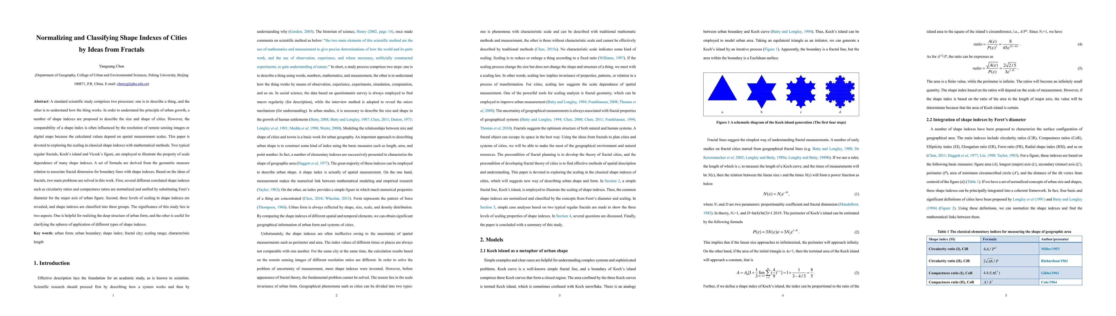
A standard scientific study comprises two processes: one is to describe a thing, and the other is to understand how the thing works. In order to understand the principle of urban growth, a number of shape indexes are proposed to describe the size and shape of cities. However, the comparability of a shape index is often influenced by the resolution of remote sensing images or digital maps because the calculated values depend on spatial measurement scales. This paper is devoted to exploring the scaling in classical shape indexes with mathematical methods. Two typical regular fractals, Koch's island and Vicsek's figure, are employed to illustrate the property of scale dependence of many shape indexes. A set of formula are derived from the geometric measure relation to associate fractal dimension for boundary lines with shape indexes. Based on the ideas of fractals, two main problems are solved in this work. First, several different correlated shape indexes such as circularity ratios and compactness ratios are normalized and unified by substituting Feret's diameter for the major axis of urban figure. Second, three levels of scaling in shape indexes are revealed, and shape indexes are classified into three groups. The significance of this study lies in two aspects. One is helpful for realizing the deep structure of urban form, and the other is useful for clarifying the spheres of application of different types of shape indexes.
AI Key Findings
Get AI-generated insights about this paper's methodology, results, significance, and more — seven facets brought into focus.
Impact
Paper Details
Authors
PDF Preview
Key Terms
Citation Network
Current paper (gray), citations (green), references (blue)
Display is limited for performance on very large graphs.
Discussion 0