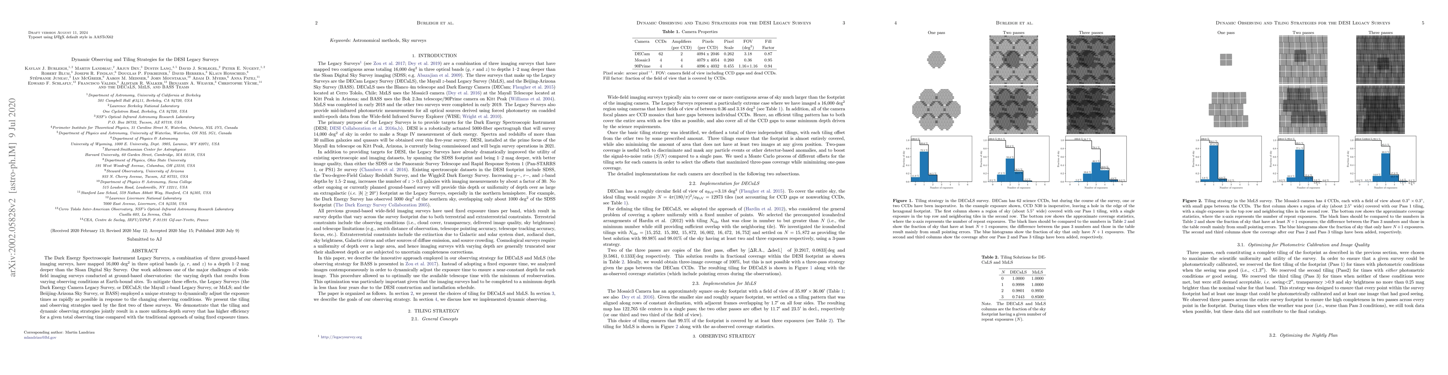
The Legacy Surveys dynamically adjust exposure times to achieve uniform depth across varying observing conditions, resulting in a more efficient and consistent survey compared to traditional fixed exposure times. This strategy enhances the survey's depth and efficiency, mapping 16,000 deg$^2$ in three optical bands.
The Legacy Surveys, a combination of three ground-based imaging surveys, have mapped 16,000 deg$^2$ in three optical bands ($g$, $r$, and $z$) to a depth 1--$2$~mag deeper than the Sloan Digital Sky Survey (SDSS). Our work addresses one of the major challenges of wide-field imaging surveys conducted at ground-based observatories: the varying depth that results from varying observing conditions at Earth-bound sites. To mitigate these effects, two of the Legacy Surveys (the Dark Energy Camera Legacy Survey, or DECaLS; and the Mayall $z$-band Legacy Survey, or MzLS) employed a unique strategy to dynamically adjust the exposure times as rapidly as possible in response to the changing observing conditions. We present the tiling and observing strategies used by these surveys. We demonstrate that the tiling and dynamic observing strategies jointly result in a more uniform-depth survey that has higher efficiency for a given total observing time compared with the traditional approach of using fixed exposure times.
Generated Sep 03, 2025
The Legacy Surveys employed a dynamic observing strategy, adjusting exposure times in response to changing conditions to ensure uniform depth across 16,000 deg² in three optical bands ($g$, $r$, and $z$). This strategy was implemented using two Python software 'bots' (copilot and decbot/mosbot) to monitor observing conditions and telescope offsets, adjusting exposure times with a lag of 1-2 frames.
This research is significant as it introduces an automated dynamic exposure time method for ground-based surveys, which can conserve telescope time and improve depth uniformity, crucial for cosmological studies and transient searches.
The development and implementation of automated dynamic exposure time adjustment software (copilot, decbot, mosbot) for ground-based imaging surveys, ensuring uniform depth and efficient use of observing time.
This work is novel as it is the first to implement automated dynamic exposure times in large-scale ground-based surveys, significantly improving depth uniformity and survey efficiency.
Current paper (gray), citations (green), references (blue)
Display is limited for performance on very large graphs.
Siegfried Eggl, Cyrielle Opitom, Hsing Wen Lin et al.
S. C. C. Barros, A. Castro-González, O. D. S. Demangeon et al.
Nicolas Regnault, Rachel Mandelbaum, Marc Moniez et al.
Title | Authors | Year | Actions |
---|
Comments (0)