This paper proposes a semi-automatic method using BFAST to map burned areas and assess burn severity from Landsat-7 images without prior fire date knowledge. The method shows high accuracy (92%) in mapping a 2012 wildfire in Jalisco, Mexico, and identifies smaller fires not recorded officially.
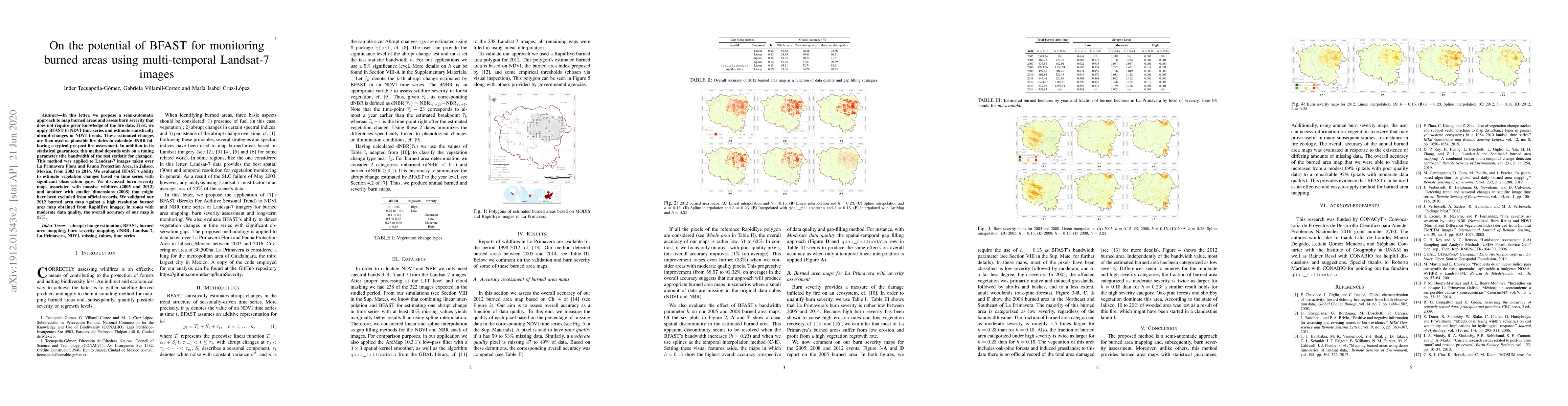
In this paper, we propose a semi-automatic approach to map burned areas and assess burn severity that does not require prior knowledge of the fire date. First, we apply BFAST to NDVI time series and estimate statistically abrupt changes in NDVI trends. These estimated changes are then used as plausible fire dates to calculate dNBR following a typical pre-post fire assessment. In addition to its statistical guarantees, this method depends only on a tuning parameter (the bandwidth of the test statistic for changes). This method was applied to Landsat-7 images taken over La Primavera Flora and Fauna Protection Area, in Jalisco, Mexico, from 2003 to 2016. We evaluated BFAST's ability to estimate vegetation changes based on time series with significant observation gaps. We discussed burn severity maps associated with massive wildfires (2005 and 2012) and another with smaller dimensions (2008) that might have been excluded from official records. We validated our 2012 burned area map against a high resolution burned area map obtained from RapidEye images; in zones with moderate data quality, the overall accuracy of our map is 92%.
Get AI-generated insights about this paper's methodology, results, and significance.
Current paper (gray), citations (green), references (blue)
Alejandro Miranda, Jaime Carrasco, Ian Mancilla-Wulff et al.
Daniele Rege Cambrin, Paolo Garza, Luca Colomba
No citations found for this paper.
Title | Authors | Year | Actions |
---|---|---|---|
A patch-based algorithm for global and daily burned area mapping
|
M. Campagnolo, D. Oom, M. Padilla, J. Pereira
|
2019
|
View Paper |
Landsat-8 and Sentinel-2 burned area mapping - A combined sensor multi-temporal change detection approach
|
D. Roy, Haiyan Huang, L. Boschetti, L. Giglio, Lin Yan, Han Zhang, Zhongbin Li
|
2019
|
View Paper |
Historical background and current developments for mapping burned area from satellite Earth observation
|
E. Chuvieco, F. Mouillot, G. R. van der Werf, Jesús San Miguel, M. Tanase, N. Koutsias, Mariano García, M. Yebra, M. Padilla, I. Gitas, A. Heil, T. Hawbaker, L. Giglio
|
2019
|
View Paper |
Remote Sensing Detection of Vegetation and Landform Damages by Coal Mining on the Tibetan Plateau
|
Qianhan Wu, Kai Liu, Chunqiao Song, Jida Wang, L. Ke, R. Ma, Wensong Zhang, Hang Pan, Xinyu Deng
|
2018
|
View Paper |
Mapping burned areas using dense time-series of Landsat data
|
T. Hawbaker, M. Vanderhoof, Yen-Ju Beal, J. D. Takacs, G. Schmidt, J. Falgout, Brad Williams, Nicole M. Fairaux, M. K. Caldwell, J. Picotte, S. Howard, Susan Stitt, J. Dwyer
|
2017
|
View Paper |
Cloud detection algorithm comparison and validation for operational Landsat data products
|
Steve Foga, P. Scaramuzza, Song Guo, Zhe Zhu, Ronald D. Dilley, Tim Beckmann, G. Schmidt, J. Dwyer, M. Hughes, Brady Laue
|
2017
|
View Paper |
Monitoring ecosystem dynamics in northwestern Ethiopia using NDVI and climate variables to assess long term trends in dryland vegetation variability
|
Worku Zewdie, E. Csaplovics, Luis Inostroza
|
2017
|
View Paper |
Sustainable Development Goals
|
Ruth Oniang'o
|
2016
|
View Paper |
Performance of vegetation indices from Landsat time series in deforestation monitoring
|
M. Schultz, J. Clevers, S. Carter, J. Verbesselt, V. Avitabile, Hien Vu Quang, M. Herold
|
2016
|
View Paper |
Monitoring forest cover loss using multiple data streams, a case study of a tropical dry forest in Bolivia
|
L. Dutrieux, J. Verbesselt, L. Kooistra, M. Herold
|
2015
|
View Paper |
MODIS–Landsat fusion for large area 30m burned area mapping
|
L. Boschetti, D. Roy, C. Justice, M. Humber
|
2015
|
View Paper |
Use of Vegetation Change Tracker and Support Vector Machine to Map Disturbance Types in Greater Yellowstone Ecosystems in a 1984–2010 Landsat Time Series
|
Feng R. Zhao, Chengquan Huang, Zhiliang Zhu
|
2015
|
View Paper |
An integrated Landsat time series protocol for change detection and generation of annual gap-free surface reflectance composites
|
T. Hermosilla, M. Wulder, Joanne C. White, N. Coops, Geordie W. Hobart
|
2015
|
View Paper |
Effectiveness of the BFAST algorithm for detecting vegetation response patterns in a semi-arid region
|
L. Watts, S. Laffan
|
2014
|
View Paper |
Incendios en el bosque la primavera (Jalisco, México): un acercamiento a sus posibles causas y consecuencias
|
F. Huerta-Martínez, José Luis Ibarra-Montoya
|
2014
|
View Paper |
Development of an automated method for mapping fire history captured in Landsat TM and ETM + time series across Queensland, Australia
|
Nicholas Goodwin, L. Collett
|
2014
|
View Paper |
Pixel-Based Image Compositing for Large-Area Dense Time Series Applications and Science
|
Joanne C. White, M. Wulder, Geordie W. Hobart, J. Luther, T. Hermosilla, P. Griffiths, N. Coops, Ronald J. Hall, P. Hostert, A. Dyk, L. Guindon
|
2014
|
View Paper |
Current research issues related to post-wildfire runoff and erosion processes
|
J. Moody, R. Shakesby, P. Robichaud, S. Cannon, D. Martin
|
2013
|
View Paper |
FIREMON: Fire Effects Monitoring and Inventory System
|
Duncan C. Lutes, R. Keane, John F. Caratti, C. H. Key, N. Benson, S. Sutherland, Larry J. Gangi
|
2012
|
View Paper |
Positive and Negative Information for Assessing and Revising Scores of Burn Evidence
|
D. Stroppiana, Gloria Bordogna, M. Boschetti, P. Carrara, L. Boschetti, P. Brivio
|
2012
|
View Paper |
Phenological change detection while accounting for abrupt and gradual trends in satellite image time series
|
J. Verbesselt, Rob J Hyndman, A. Zeileis, D. Culvenor
|
2010
|
View Paper |
An active-fire based burned area mapping algorithm for the MODIS sensor
|
L. Giglio, T. Loboda, D. Roy, B. Quayle, C. Justice
|
2009
|
View Paper |
Global characterization of fire activity: toward defining fire regimes from Earth observation data
|
E. Chuvieco, L. Giglio, C. Justice
|
2008
|
View Paper |
Fire severity assessment by using NBR (Normalized Burn Ratio) and NDVI (Normalized Difference Vegetation Index) derived from LANDSAT TM/ETM images
|
S. Escuin, R. Navarro, P. Fernández
|
2008
|
View Paper |
Gaps‐fill of SLC‐off Landsat ETM+ satellite image using a geostatistical approach
|
Chuanrong Zhang, Wei Li, David J. Travis
|
2007
|
View Paper |
A Project for Monitoring Trends in Burn Severity
|
J. Eidenshink, B. Schwind, Ken Brewer, Zhi-liang Zhu, B. Quayle, S. Howard
|
2007
|
View Paper |
Quantifying burn severity in a heterogeneous landscape with a relative version of the delta Normalized Burn Ratio (dNBR)
|
Jay D. Miller, A. Thode
|
2007
|
View Paper |
Postfire soil burn severity mapping with hyperspectral image unmixing
|
P. Robichaud, S. A. Lewis, D. Laes, A. Hudak, R. Kokaly, J. Zamudio
|
2007
|
View Paper |
Use of a radiative transfer model to simulate the postfire spectral response to burn severity
|
E. Chuvieco, D. Riaño, F. Danson, Pilar Martín
|
2006
|
View Paper |
Ecological and Sampling Constraints on Defining Landscape Fire Severity
|
C. H. Key
|
2006
|
View Paper |
Effects of differing wildfire severities on soil wettability and implications for hydrological response
|
S. Doerr, R. Shakesby, W. Blake, C. Chafer, G. Humphreys, P. Wallbrink
|
2006
|
View Paper |
A Landsat surface reflectance dataset for North America, 1990-2000
|
J. Masek, E. Vermote, N. Saleous, R. Wolfe, F. Hall, K. Huemmrich, F. Gao, J. Kutler, T. Lim
|
2006
|
View Paper |
Remote sensing of fire severity: assessing the performance of the normalized burn ratio
|
D. Roy, L. Boschetti, S. Trigg
|
2006
|
View Paper |
Comparison of burn severity assessments using Differenced Normalized Burn Ratio and ground data
|
Allison E. Cocke, P. Fulé, Joseph E. Crouse
|
2005
|
View Paper |
Landscape-level interactions of prefire vegetation, burn severity, and postfire vegetation over a 16-year period in interior Alaska
|
J. Epting, D. Verbyla
|
2005
|
View Paper |
Comparison of AVIRIS and Landsat ETM+ detection capabilities for burn severity
|
J. W. Wagtendonk, R. Root, C. H. Key
|
2004
|
View Paper |
The use of multi-temporal Landsat Normalized Difference Vegetation Index (NDVI) data for mapping fuel models in Yosemite National Park, USA
|
Jan W. van Wagtendonk, R. Root
|
2003
|
View Paper |
Mapping forest post-fire canopy consumption in several overstory types using multi-temporal Landsat TM and ETM data
|
Jay D. Miller, S. Yool
|
2002
|
View Paper |
Strucchange: An R package for testing for structural change in linear regression models
|
A. Zeileis, F. Leisch, K. Hornik, Christian Kleiber
|
2002
|
View Paper |
Mapping fire-induced vegetation depletion in the Peloncillo Mountains, Arizona and New Mexico
|
J. Rogan, S. Yool
|
2001
|
View Paper |
Assessing the accuracy of remotely sensed data : principles and practices
|
R. Congalton, K. Green
|
1998
|
View Paper |
Second Simulation of the Satellite Signal in the Solar Spectrum, 6S: an overview
|
E. Vermote, D. Tanré, J. Deuze, M. Herman, Jean-Jacques Morcette
|
1997
|
View Paper |
Mosum Tests for Parameter Constancy
|
C. Chu, K. Hornik, Chung-Ming Kuan
|
1995
|
View Paper |
World Fire: The Culture of Fire on Earth
|
S. Pyne
|
1995
|
View Paper |
Mapping and inventory of forest fires from digital processing of tm data
|
E. Chuvieco, R. Congalton
|
1988
|
View Paper |
Ecology of Fire
|
W. Platt
|
1984
|
View Paper |
imputeTS: Time Series Missing Value Imputation in R
|
Steffen Moritz, T. Bartz-Beielstein
|
2017
|
View Paper |
Earth observation of wildland fires in Mediterranean ecosystems
|
E. Chuvieco
|
2009
|
View Paper |
Detecting trend and seasonal 1 changes in satellite image time series 2
|
J. Verbesselt, Rob J Hyndman, G. Newnham, D. Culvenor
|
2009
|
View Paper |
Landscape Assessment ( LA ) Sampling and Analysis Methods
|
C. H. Key, N. Benson
|
2004
|
View Paper |
Efecto de la recurrencia de los incendios sobre la resiliencia post-incendio de las comunidades vegetales de Cataluña a partir de imágenes de satélite
|
R. Díaz-Delgado
|
2003
|
View Paper |
Propuesta de un nuevo índice para la cartografía de áreas quemadas: aplicación a imágenes NOAA-AVHRR y Landsat-TM
|
E. Salinero, M. Martín
|
2001
|
View Paper |
Assessment of AVHRR data for characterizing burned areas and post-fire vegetation recovery
|
M. Caetano, L. Mertes, L. Cadete, J. Pereira
|
1996
|
View Paper |
Phenological change
|
2010
|
||
Robust monitoring of smallscale forest disturbances in a tropical montane forest using Landsat time series
|
2015
|
||
Comparison of AVIRIS
|
2004
|
||
Classifying and mapping wildfire severity
|
2005
|
||
GDAL/OGR Geospatial Data Abstraction software Library
|
2019
|
||
GDAL/OGR Geospatial Data Abstraction software Library. Open Source Geospatial Foundation
|
2019
|
||
La Primavera en llamas. CONAFOR, 1 edition
|
2006
|
||
La Primavera en llamas
|
2006
|
||
Combate de incendios forestales
|
2012
|
||
Conjunto de datos vectoriales de uso del suelo y vegetación, escala 1:250 000, serie VI
|
2016
|
||
Historical background and current developments for mapping burned area from satellite earth observation. Remote sensing of environment
|
2019
|
||
Global climate observation system
|
2019
|
||
Programa de manejo Área de Protección de Flora y Fauna
|
2000
|
||
United States Geological Survey USGS, section: About Landsat
|
2016
|
||
Programa de manejoÁrea de Protección de Flora y Fauna La Primavera
|
2000
|
Showing first page preview. Click "Open Full PDF" to view the complete paper.
Your comment contains inappropriate language and has been rejected.
Are you sure you want to remove this tag? This action cannot be undone.
Someone just found a breakthrough paper!
Comments (0)