ArxivLens

Publication

Published: Feb 04, 2025
Categories: cs.RO

Metrics

Source: ArXiv

AI Quick Summary

This paper presents an online adaptive traversability estimation method for autonomous ground vehicles navigating densely vegetated environments, utilizing self-supervised data from robot-environment interaction. The approach employs a probabilistic 3D voxel representation and sparse graph updates, achieving adaptability with minimal operational data and enabling safe navigation.

Quick Answers

What methodology did the authors use?

The research presents a lidar-only, online adaptive traversability estimation method trained via self-supervised data from robot-environment interaction, utilizing a probabilistic 3D voxel representation and a sparse graph-based update system for computational efficiency. More in Methodology →

What are the key results?

The system adapts to complex, unstructured, densely vegetated environments with as little as 8 minutes of operational data. — Achieved a Matthews Correlation Coefficient (MCC) score of 0.63, indicating good performance in traversability estimation. More in Key Results →

Why is this work significant?

This research is important as it addresses the challenge of navigating densely vegetated environments for autonomous ground vehicles, offering an adaptive solution that maintains accuracy comparable to offline-trained models. More in Significance →

What are the main limitations?

The method was tested in natural terrains, so its applicability in other environments remains to be explored. — Training strategies examined were specific to voxel-based traversability estimation methods. More in Limitations →

Paper Preview

Abstract

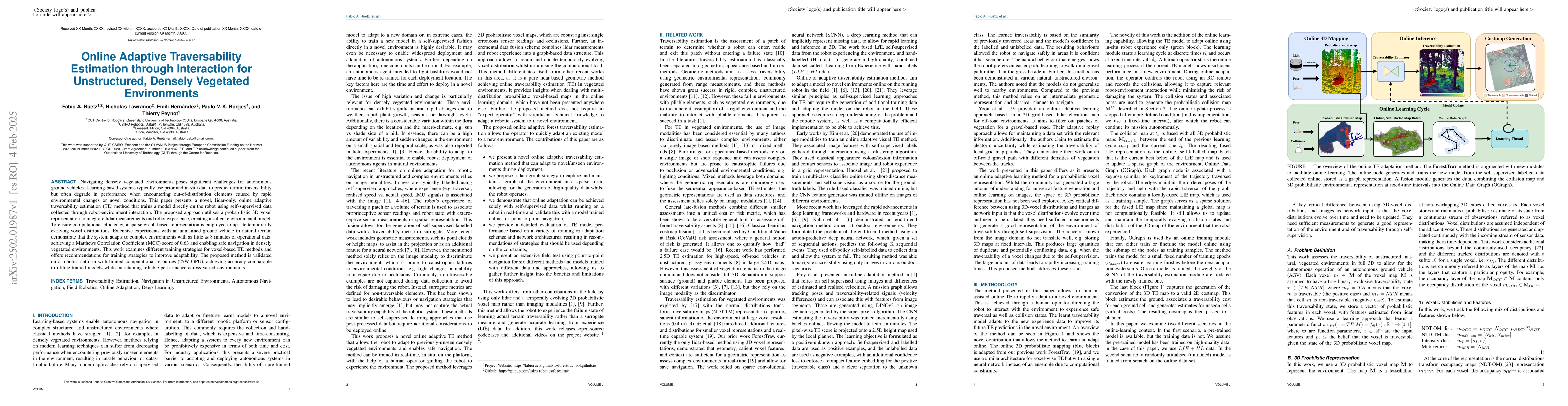
Navigating densely vegetated environments poses significant challenges for autonomous ground vehicles. Learning-based systems typically use prior and in-situ data to predict terrain traversability but often degrade in performance when encountering out-of-distribution elements caused by rapid environmental changes or novel conditions. This paper presents a novel, lidar-only, online adaptive traversability estimation (TE) method that trains a model directly on the robot using self-supervised data collected through robot-environment interaction. The proposed approach utilises a probabilistic 3D voxel representation to integrate lidar measurements and robot experience, creating a salient environmental model. To ensure computational efficiency, a sparse graph-based representation is employed to update temporarily evolving voxel distributions. Extensive experiments with an unmanned ground vehicle in natural terrain demonstrate that the system adapts to complex environments with as little as 8 minutes of operational data, achieving a Matthews Correlation Coefficient (MCC) score of 0.63 and enabling safe navigation in densely vegetated environments. This work examines different training strategies for voxel-based TE methods and offers recommendations for training strategies to improve adaptability. The proposed method is validated on a robotic platform with limited computational resources (25W GPU), achieving accuracy comparable to offline-trained models while maintaining reliable performance across varied environments.

Key Findings, in focus

Seven facets of this paper, analysed and brought into focus by AI.

AI-generated · verify against source Generated Jun 12, 2025
In focus · one-line synthesis

This research is important as it addresses the challenge of navigating densely vegetated environments for autonomous ground vehicles, offering an adaptive solution that maintains accuracy comparable to offline-trained models.

01
MethodologyHow they did it

The research presents a lidar-only, online adaptive traversability estimation method trained via self-supervised data from robot-environment interaction, utilizing a probabilistic 3D voxel representation and a sparse graph-based update system for computational efficiency.

02
ResultsWhat they found
  • The system adapts to complex, unstructured, densely vegetated environments with as little as 8 minutes of operational data.
  • Achieved a Matthews Correlation Coefficient (MCC) score of 0.63, indicating good performance in traversability estimation.
  • Demonstrated reliable performance across varied environments with limited computational resources (25W GPU).
03
SignificanceWhy it matters

This research is important as it addresses the challenge of navigating densely vegetated environments for autonomous ground vehicles, offering an adaptive solution that maintains accuracy comparable to offline-trained models.

04
Technical ContributionsWhat's new technically

The paper introduces an online adaptive traversability estimation method using a probabilistic 3D voxel representation and a sparse graph-based update system, ensuring computational efficiency.

05
NoveltyWhat sets it apart

This work distinguishes itself by focusing on self-supervised learning through robot-environment interaction, enabling adaptive traversability estimation in real-time with minimal prior data, and validating it on a low-power GPU platform.

06
LimitationsWhat to be cautious about
  • The method was tested in natural terrains, so its applicability in other environments remains to be explored.
  • Training strategies examined were specific to voxel-based traversability estimation methods.
07
Future WorkWhere it goes next
  • Explore applicability in diverse environments beyond natural terrains.
  • Investigate additional training strategies for voxel-based traversability estimation methods.

Paper Details

Paper ID: 2502.01987
Comments: Preprint
Categories:
cs.RO

How to Cite This Paper

Reference manager: RIS EndNote


No references found for this paper.


Discussion 0

This website uses cookies to ensure you get the best experience. Learn more