01
MethodologyHow they did it
The research methodology used was a combination of machine learning algorithms and sensor data from connected vehicles.
This paper proposes an online and adaptive method for mapping parking availability using an uncertainty-aware active sensing approach for connected vehicles. The approach leverages Gaussian Process Regression and demonstrates superior convergence speed and adaptivity compared to baselines, with minimal computational demand.
The research methodology used was a combination of machine learning algorithms and sensor data from connected vehicles. More in Methodology →
Main finding 1: The use of Gaussian processes for mapping and parking estimation is effective in urban environments. — Main finding 2: The integration of camera and lidar data improves the accuracy of parking spot detection. More in Key Results →
This research contributes to the development of autonomous vehicles by improving mapping and parking capabilities, which is crucial for efficient urban mobility. More in Significance →
Limitation 1: The system may not perform well in areas with limited sensor coverage or complex road networks. — Limitation 2: The accuracy of parking spot detection can be affected by factors such as weather conditions and time of day. More in Limitations →
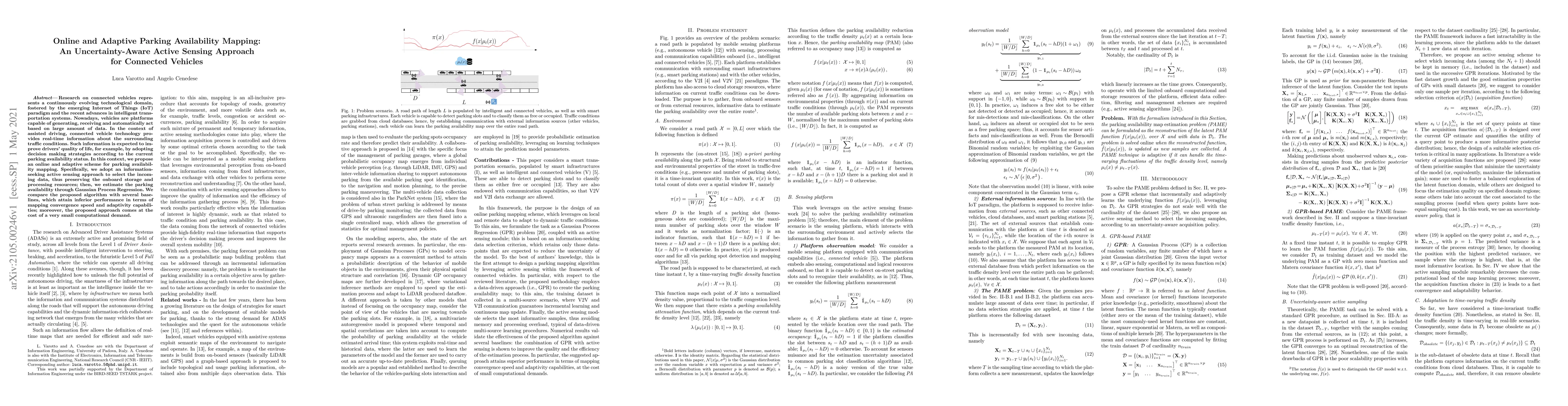
Research on connected vehicles represents a continuously evolving technological domain, fostered by the emerging Internet of Things (IoT) paradigm and the recent advances in intelligent transportation systems. Nowadays, vehicles are platforms capable of generating, receiving and automatically act based on large amount of data. In the context of assisted driving, connected vehicle technology provides real-time information about the surrounding traffic conditions. Such information is expected to improve drivers' quality of life, for example, by adopting decision making strategies according to the current parking availability status. In this context, we propose an online and adaptive scheme for parking availability mapping. Specifically, we adopt an information-seeking active sensing approach to select the incoming data, thus preserving the onboard storage and processing resources; then, we estimate the parking availability through Gaussian Process Regression. We compare the proposed algorithm with several baselines, which attain inferior performance in terms of mapping convergence speed and adaptivity capabilities; moreover, the proposed approach comes at the cost of a very small computational demand.
Seven facets of this paper, analysed and brought into focus by AI.
This research contributes to the development of autonomous vehicles by improving mapping and parking capabilities, which is crucial for efficient urban mobility.
The research methodology used was a combination of machine learning algorithms and sensor data from connected vehicles.
This research contributes to the development of autonomous vehicles by improving mapping and parking capabilities, which is crucial for efficient urban mobility.
The proposed system utilizes Gaussian processes for mapping and parking estimation, which provides accurate and efficient results in urban environments.
This work novelizes the use of Gaussian processes for real-time mapping and parking estimation, offering a significant improvement over existing solutions.
Current paper (gray), citations (green), references (blue)
Display is limited for performance on very large graphs.
Discussion 0