Summary

We present an online semantic object mapping system for a quadruped robot operating in real indoor environments, turning sensor detections into named objects in a global map. During a run, the mapper integrates range geometry with camera detections, merges co-located detections within a frame, and associates repeated detections into persistent object instances across frames. Objects remain in the map when they are out of view, and repeated sightings update the same instance rather than creating duplicates. The output is a compact object layer that can be queried (class, pose, and confidence), is integrated with the occupancy map and readable by a planner. In on-robot tests, the layer remained stable across viewpoint changes.

AI Key Findings

Generated Oct 22, 2025

Methodology

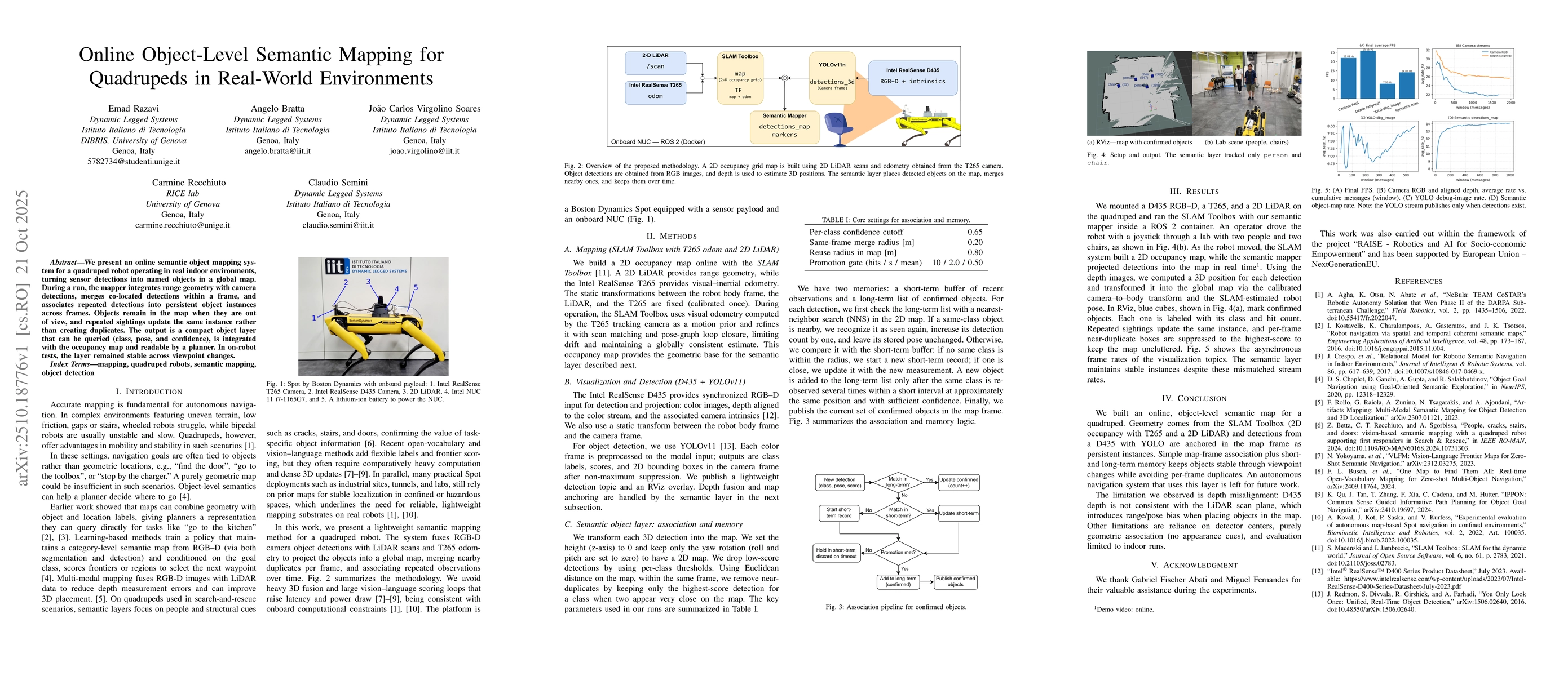
The research employs a multi-sensor fusion approach combining SLAM Toolbox for 2D occupancy mapping with a D435 RGB-D camera and YOLO for object detection. The semantic mapper integrates depth data and calibrated camera-to-body transforms to project detections into a global map frame as persistent instances.

Key Results

  • The system successfully tracks objects like people and chairs in real-time while maintaining stable instances across viewpoint changes
  • Asynchronous sensor streams are managed effectively with frame rate synchronization techniques
  • The semantic layer provides continuous object tracking without per-frame duplicates through short- and long-term memory mechanisms

Significance

This research advances autonomous navigation by enabling robots to maintain persistent object representations in dynamic environments, which is critical for tasks requiring spatial awareness and object interaction.

Technical Contribution

A novel semantic mapping framework that combines SLAM-based 2D occupancy maps with real-time object detection, using calibrated transforms and memory mechanisms to maintain persistent object instances across viewpoint changes.

Novelty

The work introduces a persistent object representation system that integrates geometric SLAM data with semantic detection, using both short- and long-term memory to maintain stable object instances despite asynchronous sensor streams.

Limitations

  • Depth misalignment between D435 and LiDAR introduces range/pose biases in object placement
  • Reliance on detector centers rather than appearance cues limits robustness in challenging scenarios

Future Work

  • Developing more robust appearance-based object association methods
  • Exploring multi-modal sensor fusion for improved depth alignment
  • Integrating the semantic layer into autonomous navigation systems for real-world applications

Paper Details

PDF Preview

Download PDF

Comments (0)

This website uses cookies to ensure you get the best experience. Learn more