OPAL introduces an omnidirectional, 360-degree in-place yaw rotation at ambiguous branch points to reduce global planning complexity. It uses a Reachable-Vicinity Filter to constrain frontier candidates, a Decision Gate to select progress, and a Local Selector that can operate with model-free or language-model-based evidence. Variants compare model-free, LLM-based, and VLM-based frontier selection, and analyze performance across different vicinity radii using simulations and on-board hardware tests with a Modal AI drone.
OPAL: Omnidirectional Path-efficient Aerial 3D expLoration
Publication
Metrics
AI Quick Summary
OPAL is an aerial exploration framework that prioritizes 360-degree yaw rotation at decision points instead of heavy global route planning, aiming for lower travel distance and simpler computation. By testing multiple frontier-selection strategies (including model-free, LLM, and VLM variants) and adjusting the search radius, OPAL achieves shorter traveled distances and competitive coverage, with a tradeoff between exploration time and distance; experiments on simulated environments and a Modal AI drone show OPAL can reduce travel distance by up to 25% compared to FALCON while remaining computationally simpler.
Quick Answers
What is "OPAL: Omnidirectional Path-efficient Aerial 3D expLoration" about?
OPAL is an aerial exploration framework that prioritizes 360-degree yaw rotation at decision points instead of heavy global route planning, aiming for lower travel distance and simpler computation. By testing multiple frontier-selection strategies (including model-free, LLM, and VLM variants) and adjusting the search radius, OPAL achieves shorter traveled distances and competitive coverage, with a tradeoff between exploration time and distance; experiments on simulated environments and a Modal AI drone show OPAL can reduce travel distance by up to 25% compared to FALCON while remaining computationally simpler.
What methodology did the authors use?
OPAL introduces an omnidirectional, 360-degree in-place yaw rotation at ambiguous branch points to reduce global planning complexity. It uses a Reachable-Vicinity Filter to constrain frontier candidates, a Decision Gate to select progress, and a Local Selector that can operate with model-free or language-model-based evidence. Variants compare model-free, LLM-based, and VLM-based frontier selection, and analyze performance across different vicinity radii using... More in Methodology →
What are the key results?
OPAL achieves shorter travel distances and higher coverage-versus-distance AUC than baselines like EDEN and FALCON, despite longer total exploration times due to yaw rotations. — Increasing the frontier-selection search radius yields a trade-off between travel distance and total exploration time, allowing tunable performance. More in Key Results →
Why is this work significant?
Demonstrates that a lightweight, locally reactive frontier arbitration layer with deliberate 360-degree pan can rival heavier global planners in 3D aerial exploration while reducing travel distance and preserving mapping coverage. More in Significance →
What are the main limitations?
Longer exploration times arise from the in-place yaw rotations, which may impact time-critical missions. — Performance depends on proper tuning of the vicinity radius and frontier-views alignment, which may vary across environments. More in Limitations →
Abstract
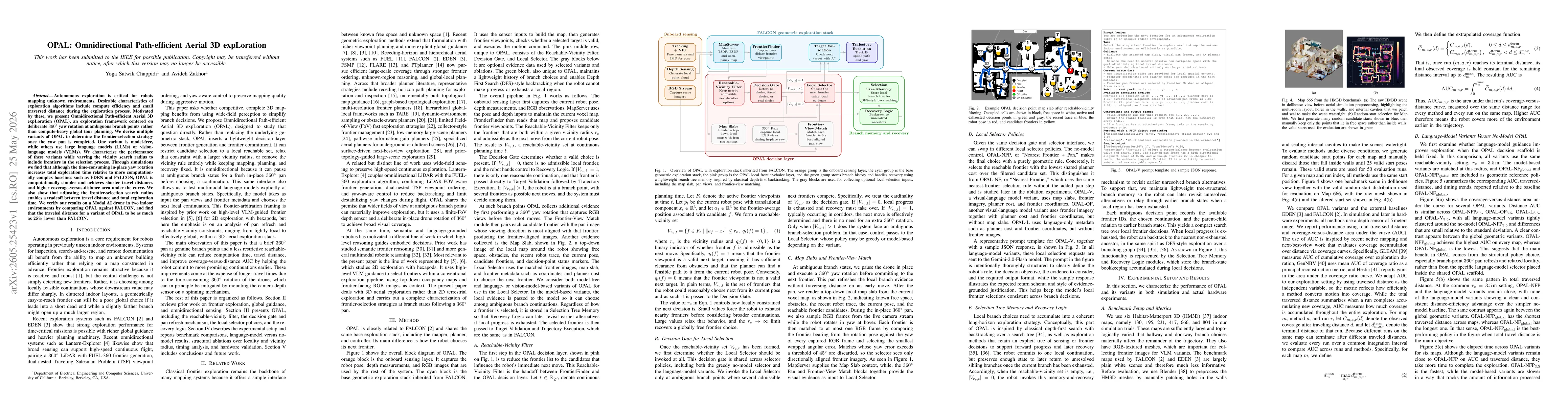
Autonomous exploration is critical for robot mapping unknown environments. Desirable characteristics of exploration algorithms include compute efficiency and small traversed distance during the exploration process. Motivated by these, we present Omnidirectional Path-efficient Aerial 3D expLoration (OPAL), an exploration framework centered on deliberate 360-degree yaw rotation at ambiguous branch points rather than compute-heavy global tour planning. We devise multiple variants of OPAL to determine the frontier-selection strategy once the yaw pan is completed. One variant is model-free, while others use large language models (LLMs) or vision-language models (VLMs). We characterize the performance of these variants while varying the vicinity search radius to include frontiers in the selection process. Through simulations we find that although the time-consuming in-place yaw rotation increases total exploration time relative to more computationally complex baselines such as EDEN and FALCON, OPAL is computationally simpler and achieves shorter travel distances and higher coverage-versus-distance area under the curve. We also show that adjusting the frontier-selection search radius enables a tradeoff between travel distance and total exploration time. We verify our results on a Modal AI drone in two indoor environments by comparing OPAL against FALCON, and find that the traveled distance for a variant of OPAL to be as much as 25% lower than FALCON.
Key Findings, in focus
Seven facets of this paper, analysed and brought into focus by AI.
Demonstrates that a lightweight, locally reactive frontier arbitration layer with deliberate 360-degree pan can rival heavier global planners in 3D aerial exploration while reducing travel distance and preserving mapping coverage.
- OPAL achieves shorter travel distances and higher coverage-versus-distance AUC than baselines like EDEN and FALCON, despite longer total exploration times due to yaw rotations.
- Increasing the frontier-selection search radius yields a trade-off between travel distance and total exploration time, allowing tunable performance.
- Onboard hardware experiments indicate at least 25% reduction in traveled distance for a OPAL variant compared to FALCON in indoor tests.
Demonstrates that a lightweight, locally reactive frontier arbitration layer with deliberate 360-degree pan can rival heavier global planners in 3D aerial exploration while reducing travel distance and preserving mapping coverage.
OPAL provides a novel decision layer between frontier generation and commitment, introducing a Reachable-Vicinity Filter, a Decision Gate, and a Local Selector capable of model-free or LLM/VLM-guided choices, all integrated with a 360-degree pan at branch points for 3D aerial exploration.
First to systematically characterize frontier-selection strategies at branchpoints in 3D aerial exploration with an omnidirectional in-place yaw mechanism, including the option to leverage language or vision-language models for local decision making within a unified exploration stack.
- Longer exploration times arise from the in-place yaw rotations, which may impact time-critical missions.
- Performance depends on proper tuning of the vicinity radius and frontier-views alignment, which may vary across environments.
- Hardware validation is limited to indoor drone tests and a single platform, limiting generalization to other aerial platforms or outdoor scenarios.
- Explore hardware modifications to enable faster panoramic sensing, such as lightweight spinning depth sensors.
- Extend evaluation to diverse environments (outdoor, dynamic obstacles) and additional drone platforms.
- Develop adaptive radius selection strategies to automatically balance travel distance and exploration time in real time.
Discussion 0