ArxivLens
ArXiv cs.SI cs.IR eess.SP

OpenSky Report 2025: Improving Crowdsourced Flight Trajectories with ADS-C Data

Junzi Sun, Martin Strohmeier, Vincent Lenders, Xavier Olive

2505.06254 Published May 1, 2025
View PDF

Publication

Published: May 01, 2025
Updated: Jun 17, 2025
Categories: cs.SI, cs.IR, eess.SP

Metrics

Source: ArXiv

AI Quick Summary

The OpenSky Network integrates ADS-B and ADS-C data to enhance global flight trajectory coverage, improving accuracy for long-haul routes, especially over oceans and remote areas. This advancement facilitates better fuel consumption estimates and new research opportunities in aviation management and environmental impact assessment.

Quick Answers

What is "OpenSky Report 2025: Improving Crowdsourced Flight Trajectories with ADS-C Data" about?

The OpenSky Network integrates ADS-B and ADS-C data to enhance global flight trajectory coverage, improving accuracy for long-haul routes, especially over oceans and remote areas. This advancement facilitates better fuel consumption estimates and new research opportunities in aviation management and environmental impact assessment.

What methodology did the authors use?

The research analyzes a dataset of over 720,000 ADS-C messages collected in 2024 via the Alphasat satellite, integrating ADS-B and ADS-C data to construct detailed long-haul flight paths, particularly for transatlantic and African routes. More in Methodology →

What are the key results?

Integration of ADS-B and ADS-C data significantly improves trajectory reconstruction accuracy. — Combined data captures flight patterns across previously underrepresented regions in Africa. More in Key Results →

Why is this work significant?

This work advances open access to global flight trajectory data, enabling new research opportunities in air traffic management, environmental impact assessment, and aviation safety. More in Significance →

What are the main limitations?

Coverage limitations due to reliance on satellite communication for ADS-C data over oceans and remote areas. — Data collection primarily focused on specific regions: Europe, Africa, and parts of the Atlantic Ocean. More in Limitations →

Paper Preview

Abstract

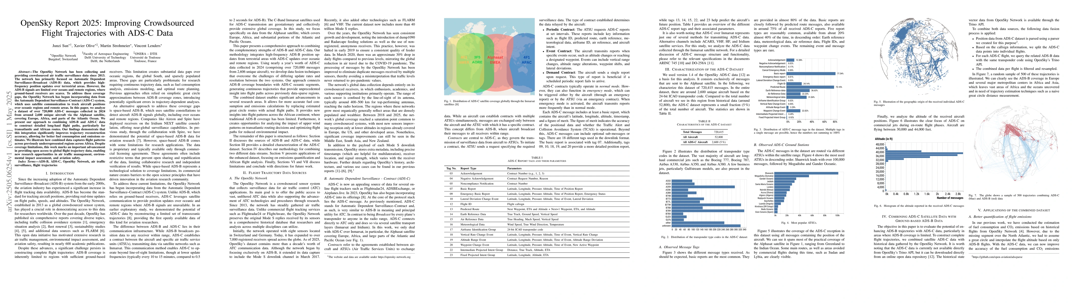
The OpenSky Network has been collecting and providing crowdsourced air traffic surveillance data since 2013. The network has primarily focused on Automatic Dependent Surveillance--Broadcast (ADS-B) data, which provides high-frequency position updates over terrestrial areas. However, the ADS-B signals are limited over oceans and remote regions, where ground-based receivers are scarce. To address these coverage gaps, the OpenSky Network has begun incorporating data from the Automatic Dependent Surveillance--Contract (ADS-C) system, which uses satellite communication to track aircraft positions over oceanic regions and remote areas. In this paper, we analyze a dataset of over 720,000 ADS-C messages collected in 2024 from around 2,600 unique aircraft via the Alphasat satellite, covering Europe, Africa, and parts of the Atlantic Ocean. We present our approach to combining ADS-B and ADS-C data to construct detailed long-haul flight paths, particularly for transatlantic and African routes. Our findings demonstrate that this integration significantly improves trajectory reconstruction accuracy, allowing for better fuel consumption and emissions estimates. We illustrate how combined data captures flight patterns across previously underrepresented regions across Africa. Despite coverage limitations, this work marks an important advancement in providing open access to global flight trajectory data, enabling new research opportunities in air traffic management, environmental impact assessment, and aviation safety.

Key Findings, in focus

Seven facets of this paper, analysed and brought into focus by AI.

AI-generated · verify against source Generated Jun 08, 2025
In focus · one-line synthesis

This work advances open access to global flight trajectory data, enabling new research opportunities in air traffic management, environmental impact assessment, and aviation safety.

01
MethodologyHow they did it

The research analyzes a dataset of over 720,000 ADS-C messages collected in 2024 via the Alphasat satellite, integrating ADS-B and ADS-C data to construct detailed long-haul flight paths, particularly for transatlantic and African routes.

02
ResultsWhat they found
  • Integration of ADS-B and ADS-C data significantly improves trajectory reconstruction accuracy.
  • Combined data captures flight patterns across previously underrepresented regions in Africa.
03
SignificanceWhy it matters

This work advances open access to global flight trajectory data, enabling new research opportunities in air traffic management, environmental impact assessment, and aviation safety.

04
Technical ContributionsWhat's new technically

Development of an approach to effectively combine ADS-B and ADS-C data for detailed flight trajectory reconstruction.

05
NoveltyWhat sets it apart

This research is novel in its focus on integrating ADS-C data with ADS-B to address coverage gaps over oceans and remote regions, thereby improving global flight trajectory data.

06
LimitationsWhat to be cautious about
  • Coverage limitations due to reliance on satellite communication for ADS-C data over oceans and remote areas.
  • Data collection primarily focused on specific regions: Europe, Africa, and parts of the Atlantic Ocean.
07
Future WorkWhere it goes next
  • Expand data collection to cover more global regions for comprehensive flight trajectory coverage.
  • Investigate methods to enhance ADS-C data availability and quality over oceanic and remote areas.

Impact

13
References

Paper Details

Paper ID: 2505.06254
Categories:
cs.SI cs.IR eess.SP

How to Cite This Paper

Reference manager: RIS EndNote

Citation Network

Current paper (gray), citations (green), references (blue)

Display is limited for performance on very large graphs.

Current Paper
Citations
References
Click to view


Discussion 0

This website uses cookies to ensure you get the best experience. Learn more