Optimal Real Time Drone Path Planning for Harvesting Information from a Wireless Sensor Network
Publication
Metrics
AI Quick Summary
This research develops a real-time drone path planning method for harvesting data from a wireless sensor network, optimizing either total or maximum energy consumption. The authors use a homotopy approach to generate optimal drone paths for varying drone ranges, ensuring rapid execution suitable for on-the-fly recalculations.
Paper Preview
Abstract
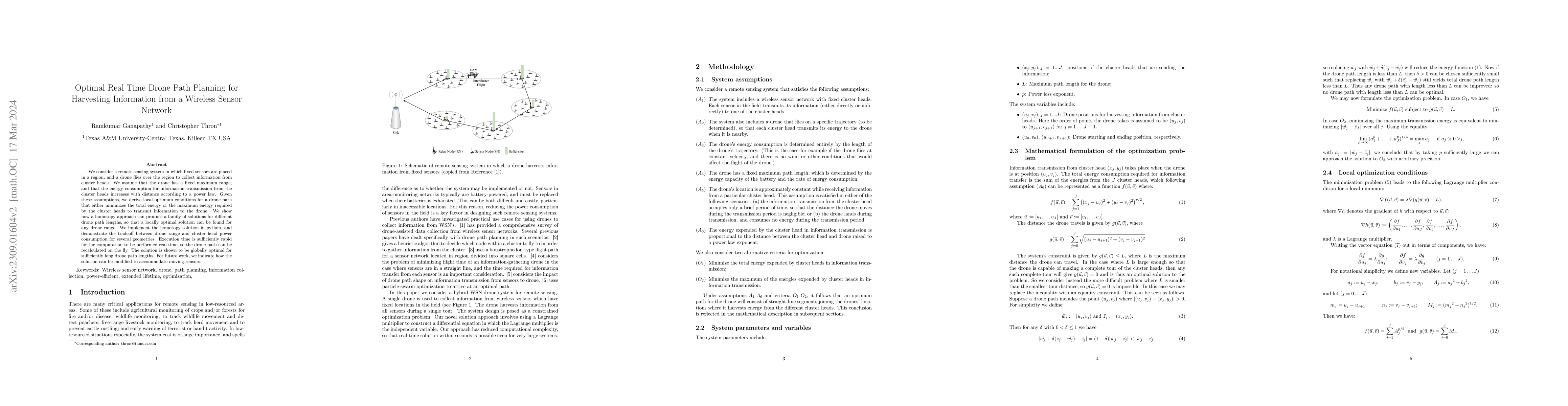
We consider a remote sensing system in which fixed sensors are placed in a region, and a drone flies over the region to collect information from cluster heads. We assume that the drone has a fixed maximum range, and that the energy consumption for information transmission from the cluster heads increases with distance according to a power law. Given these assumptions, we derive local optimum conditions for a drone path that either minimizes the total energy or the maximum energy required by the cluster heads to transmit information to the drone. We show how a homotopy approach can produce a family of solutions for different drone path lengths, so that a locally optimal solution can be found for any drone range. We implement the homotopy solution in python, and demonstrate the tradeoff between drone range and cluster head power consumption for several geometries. Execution time is sufficiently rapid for the computation to be performed real time, so the drone path can be recalculated on the fly. The solution is shown to be globally optimal for sufficiently long drone path lengths. For future work, we indicate how the solution can be modified to accommodate moving sensors.
AI Key Findings
Get AI-generated insights about this paper's methodology, results, significance, and more — seven facets brought into focus.
Impact
Paper Details
Authors
PDF Preview
Key Terms
Citation Network
Current paper (gray), citations (green), references (blue)
Display is limited for performance on very large graphs.
Discussion 0