Optimization of a Millimeter-Wave UAV-to-Ground Network in Urban Deployments
Publication
Metrics
AI Quick Summary
This paper optimizes a millimeter-wave UAV-to-ground network in urban deployments, focusing on connectivity probability. It uses stochastic geometry to characterize this probability as a function of city type, UAV density, and UAV height, revealing optimal UAV altitude for consistent connectivity.
Paper Preview
Abstract
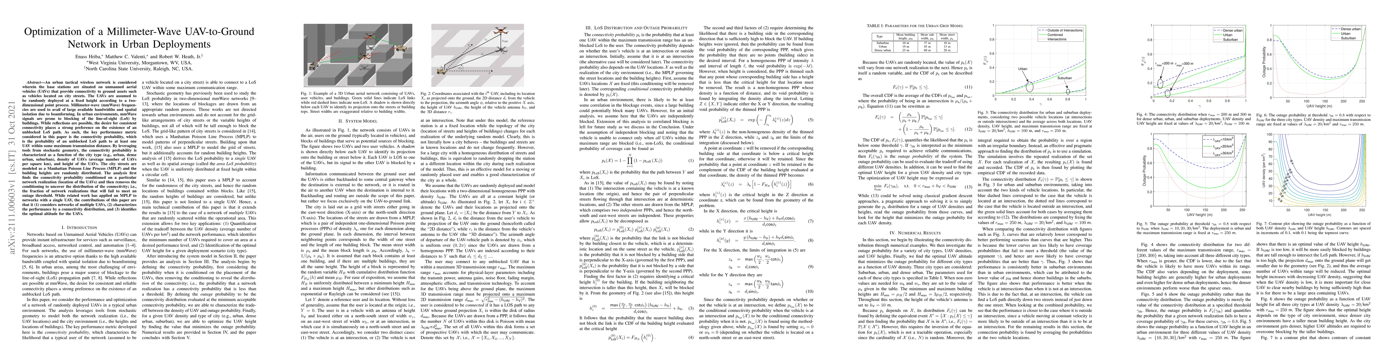
An urban tactical wireless network is considered wherein the base stations are situated on unmanned aerial vehicles (UAVs) that provide connectivity to ground assets such as vehicles located on city streets. The UAVs are assumed to be randomly deployed at a fixed height according to a two-dimensional point process. Millimeter-wave (mmWave) frequencies are used to avail of large available bandwidths and spatial isolation due to beamforming. In urban environments, mmWave signals are prone to blocking of the line-of-sight (LoS) by buildings. While reflections are possible, the desire for consistent connectivity places a strong preference on the existence of an unblocked LoS path. As such, the key performance metric considered in this paper is the connectivity probability, which is the probability of an unblocked LoS path to at least one UAV within some maximum transmission distance. By leveraging tools from stochastic geometry, the connectivity probability is characterized as a function of the city type (e.g., urban, dense urban, suburban), density of UAVs (average number of UAVs per square km), and height of the UAVs. The city streets are modeled as a Manhattan Poisson Line Process (MPLP) and the building heights are randomly distributed. The analysis first finds the connectivity probability conditioned on a particular network realization (location of the UAVs) and then removes the conditioning to uncover the distribution of the connectivity; i.e., the fraction of network realizations that will fail to meet an outage threshold. While related work has applied an MPLP to networks with a single UAV, the contributions of this paper are that it (1) considers networks of multiple UAVs, (2) characterizes the performance by a connectivity distribution, and (3) identifies the optimal altitude for the UAVs.
AI Key Findings
Get AI-generated insights about this paper's methodology, results, significance, and more — seven facets brought into focus.
Impact
Paper Details
Authors
PDF Preview
Key Terms
Citation Network
Current paper (gray), citations (green), references (blue)
Display is limited for performance on very large graphs.
Discussion 0