ArxivLens

Publication

Published: Apr 04, 2025
Categories: cs.AI, eess.SP

Metrics

Source: ArXiv

AI Quick Summary

This paper introduces an AI-powered approach to optimize the positioning of UAV-based base stations for efficient communication, adapting to various user equipment movement patterns with high accuracy.

Quick Answers

What is "Optimizing UAV Aerial Base Station Flights Using DRL-based Proximal Policy Optimization" about?

This paper introduces an AI-powered approach to optimize the positioning of UAV-based base stations for efficient communication, adapting to various user equipment movement patterns with high accuracy.

What methodology did the authors use?

This research employs a deep reinforcement learning (DRL) approach using Proximal Policy Optimization (PPO) for optimizing Unmanned Aerial Vehicle (UAV) aerial base station flights. The method leverages real-time user equipment (UE) signal characteristics instead of GPS data, enabling flexible UAV movement and robustness in scenarios with unknown UE locations. More in Methodology →

What are the key results?

The PPO-based algorithm effectively maintains comprehensive coverage across diverse UE mobility patterns, including static, random, linear, circular, and mixed hotspot movements. — The proposed approach outperforms traditional DRL methods and static UAV placement in various scenarios, demonstrating improved throughput and more balanced BS traffic loads. More in Key Results →

Why is this work significant?

This research is significant as it presents a realistic and adaptive framework for UAV trajectory planning in emergency scenarios, addressing the challenges of existing approaches that rely on unrealistic assumptions and lack flexibility in dynamic environments. More in Significance →

What are the main limitations?

The current implementation assumes perfect or noisy AoA estimations without considering other potential signal characteristics or sensor data. — The study focuses on a single UAV, and future work should explore the extension to multiple UAVs for enhanced network coverage and reliability. More in Limitations →

Paper Preview

Abstract

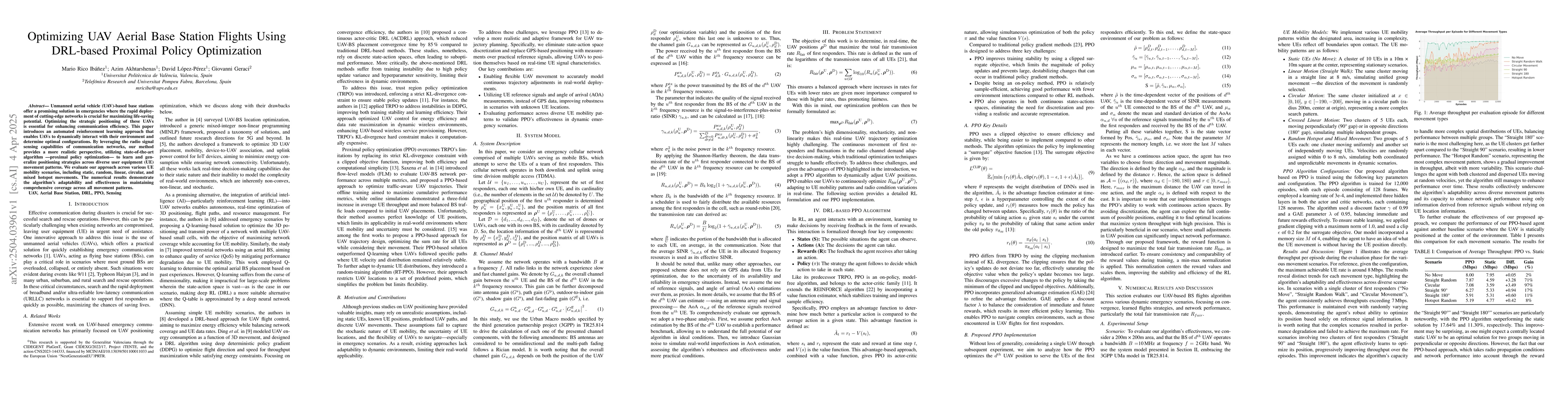
Unmanned aerial vehicle (UAV)-based base stations offer a promising solution in emergencies where the rapid deployment of cutting-edge networks is crucial for maximizing life-saving potential. Optimizing the strategic positioning of these UAVs is essential for enhancing communication efficiency. This paper introduces an automated reinforcement learning approach that enables UAVs to dynamically interact with their environment and determine optimal configurations. By leveraging the radio signal sensing capabilities of communication networks, our method provides a more realistic perspective, utilizing state-of-the-art algorithm -- proximal policy optimization -- to learn and generalize positioning strategies across diverse user equipment (UE) movement patterns. We evaluate our approach across various UE mobility scenarios, including static, random, linear, circular, and mixed hotspot movements. The numerical results demonstrate the algorithm's adaptability and effectiveness in maintaining comprehensive coverage across all movement patterns.

Key Findings, in focus

Seven facets of this paper, analysed and brought into focus by AI.

AI-generated · verify against source Generated Jun 10, 2025
In focus · one-line synthesis

This research is significant as it presents a realistic and adaptive framework for UAV trajectory planning in emergency scenarios, addressing the challenges of existing approaches that rely on unrealistic assumptions and lack flexibility in dynamic environments.

01
MethodologyHow they did it

This research employs a deep reinforcement learning (DRL) approach using Proximal Policy Optimization (PPO) for optimizing Unmanned Aerial Vehicle (UAV) aerial base station flights. The method leverages real-time user equipment (UE) signal characteristics instead of GPS data, enabling flexible UAV movement and robustness in scenarios with unknown UE locations.

02
ResultsWhat they found
  • The PPO-based algorithm effectively maintains comprehensive coverage across diverse UE mobility patterns, including static, random, linear, circular, and mixed hotspot movements.
  • The proposed approach outperforms traditional DRL methods and static UAV placement in various scenarios, demonstrating improved throughput and more balanced BS traffic loads.
  • The algorithm shows robustness to noise in angle-of-arrival (AoA) estimations, maintaining high throughput even with significant noise levels.
  • The PPO-based approach surpasses geometrically optimal static positions in complex scenarios involving multiple UE groups moving in perpendicular or opposite directions.
03
SignificanceWhy it matters

This research is significant as it presents a realistic and adaptive framework for UAV trajectory planning in emergency scenarios, addressing the challenges of existing approaches that rely on unrealistic assumptions and lack flexibility in dynamic environments.

04
Technical ContributionsWhat's new technically

The main technical contribution is the development of a PPO-based DRL algorithm for UAV aerial base station flights, which enables continuous UAV movement, utilizes practical reference signals, and improves robustness in scenarios with unknown UE locations.

05
NoveltyWhat sets it apart

This work stands out by introducing a realistic and adaptive DRL framework for UAV trajectory planning, leveraging reference signals and angle-of-arrival measurements instead of GPS data, and demonstrating effectiveness across diverse UE mobility patterns.

06
LimitationsWhat to be cautious about
  • The current implementation assumes perfect or noisy AoA estimations without considering other potential signal characteristics or sensor data.
  • The study focuses on a single UAV, and future work should explore the extension to multiple UAVs for enhanced network coverage and reliability.
07
Future WorkWhere it goes next
  • Investigate the integration of additional signal characteristics or sensor data for more accurate state representation and UAV positioning.
  • Extend the proposed framework to handle multiple UAVs for improved network coverage and coordination in emergency scenarios.

Impact

24
References

Paper Details

Paper ID: 2504.03961
Categories:
cs.AI eess.SP

How to Cite This Paper

Reference manager: RIS EndNote

Citation Network

Current paper (gray), citations (green), references (blue)

Display is limited for performance on very large graphs.

Current Paper
Citations
References
Click to view


Discussion 0

This website uses cookies to ensure you get the best experience. Learn more