Orientations and matrix function-based centralities in multiplex network analysis of urban public transport

Source: ArXiv

AI Quick Summary

This paper examines urban public transport systems as multiplex networks, comparing their orientations with street networks across 36 large German and 18 major European cities. It finds that German transport networks predominantly align with the east-west axis, mirroring street network orientations. The study also explores matrix function-based centrality measures in multiplex networks, demonstrating their effectiveness in revealing detailed geometrical properties of urban transport systems.

Share: Share on X LinkedIn

Summary

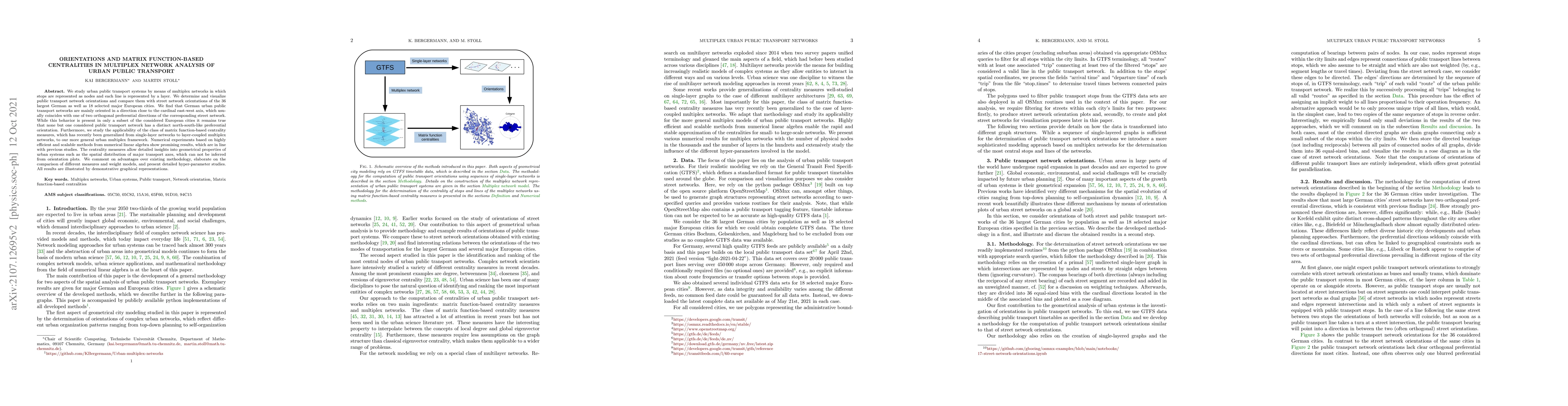
We study urban public transport systems by means of multiplex networks in which stops are represented as nodes and each line is represented by a layer. We determine and visualize public transport network orientations and compare them with street network orientations of the $36$ largest German as well as $18$ selected major European cities. We find that German urban public transport networks are mainly oriented in a direction close to the cardinal east-west axis, which usually coincides with one of two orthogonal preferential directions of the corresponding street network. While this behavior is present in only a subset of the considered European cities it remains true that none but one considered public transport network has a distinct north-south-like preferential orientation. Furthermore, we study the applicability of the class of matrix function-based centrality measures, which has recently been generalized from single-layer networks to layer-coupled multiplex networks, to our more general urban multiplex framework. Numerical experiments based on highly efficient and scalable methods from numerical linear algebra show promising results, which are in line with previous studies. The centrality measures allow detailed insights into geometrical properties of urban systems such as the spatial distribution of major transport axes, which can not be inferred from orientation plots. We comment on advantages over existing methodology, elaborate on the comparison of different measures and weight models, and present detailed hyper-parameter studies. All results are illustrated by demonstrative graphical representations.

AI Key Findings

Generated Sep 03, 2025

Methodology

The research analyzes urban public transport systems using multiplex networks, comparing orientations with street networks in 36 German and 18 European cities. Matrix function-based centralities are applied to identify and rank central lines and stops.

Key Results

  • German urban public transport networks are mainly oriented along the east-west axis, often aligning with street network preferential directions.
  • A subset of European cities exhibit similar east-west orientation, but north-south orientation is rare in public transport networks.
  • Matrix function-based centralities reveal detailed insights into urban systems' geometrical properties, such as the spatial distribution of major transport axes.
  • Numerical experiments using efficient linear algebra methods show promising results, aligning with previous studies.
  • The method allows flexible choice of locality degree and has efficient, scalable numerical implementations applicable to various problems.

Significance

This research contributes to understanding urban public transport systems' geometrical aspects, providing insights beyond orientation plots and potentially aiding in addressing economic, environmental, and social urban challenges.

Technical Contribution

The paper introduces a multiplex network model for urban public transport systems and applies matrix function-based centralities to identify and rank central lines and stops, offering a flexible and efficient method for urban analysis.

Novelty

The research extends the application of matrix function-based centralities to multiplex networks, providing a novel approach to understanding urban public transport systems' geometrical properties.

Limitations

  • The study focuses on a limited set of cities, primarily in Germany and Europe, which may limit the generalizability of findings.
  • Realistic individual transfer times are not included, which could impact the accuracy of centrality measures for some stops.

Future Work

  • Future research could incorporate realistic transfer times for a more accurate modeling of urban public transport networks.
  • Expanding the study to more diverse cities worldwide could enhance the generalizability of the findings.

Paper Details

PDF Preview

Download PDF

Key Terms

urban (0.280)
urban (0.268)
public (0.223)
street (0.220)
public (0.215)
transport (0.210)
transport (0.209)
centrality (0.205)

Citation Network

Current paper (gray), citations (green), references (blue)

Display is limited for performance on very large graphs.

Current Paper
Citations
References
Click to view
Title Authors Year Actions

Comments (0)

This website uses cookies to ensure you get the best experience. Learn more