Summary

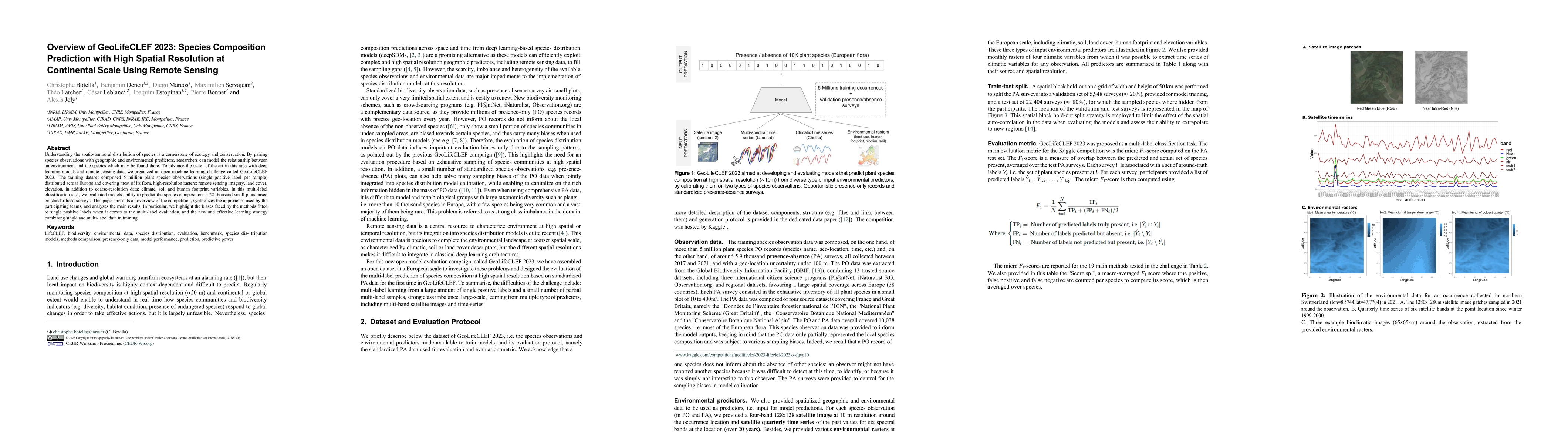
Understanding the spatio-temporal distribution of species is a cornerstone of ecology and conservation. By pairing species observations with geographic and environmental predictors, researchers can model the relationship between an environment and the species which may be found there. To advance the state-of-the-art in this area with deep learning models and remote sensing data, we organized an open machine learning challenge called GeoLifeCLEF 2023. The training dataset comprised 5 million plant species observations (single positive label per sample) distributed across Europe and covering most of its flora, high-resolution rasters: remote sensing imagery, land cover, elevation, in addition to coarse-resolution data: climate, soil and human footprint variables. In this multi-label classification task, we evaluated models ability to predict the species composition in 22 thousand small plots based on standardized surveys. This paper presents an overview of the competition, synthesizes the approaches used by the participating teams, and analyzes the main results. In particular, we highlight the biases faced by the methods fitted to single positive labels when it comes to the multi-label evaluation, and the new and effective learning strategy combining single and multi-label data in training.

AI Key Findings

Generated Oct 01, 2025

Methodology

The study organized a machine learning challenge (GeoLifeCLEF 2023) to predict species composition using remote sensing data and environmental predictors. Participants used various models including CNNs, Random Forests, and XGBoost, trained on presence-absence (PA) and presence-only (PO) data. The evaluation focused on F1-micro scores across different datasets and habitats.

Key Results

  • The KDDI team achieved the best performance with an ensemble of multi-modal CNNs trained on combined PA and PO data (F1-micro score 0.273).
  • Models trained solely on PA data outperformed those trained on PO data, highlighting the importance of calibration with PA data for reducing class detection bias.
  • Set size errors were significant, with methods like MaxEnt all sp. PA showing large biases due to over-prediction of species diversity.

Significance

This research advances species distribution modeling by leveraging high-resolution remote sensing and standardized PA data, offering insights into biodiversity assessment and ecological monitoring at large scales.

Technical Contribution

The study introduces a standardized PA dataset for evaluating species composition prediction at high spatial resolution, along with novel multi-modal CNN approaches combining different environmental predictors.

Novelty

This work is novel in its use of satellite multi-band time-series data and its integration of presence-absence and presence-only data through a cross-entropy optimization scheme to mitigate class detection bias.

Limitations

  • The study relies on opportunistic PO data, which may introduce sampling biases and detection errors.
  • Set size variability and class detection bias remain challenging to address without proper calibration with PA data.

Future Work

  • Integrate diverse predictors like time-series remote sensing and climatic variables for more comprehensive models.
  • Develop methods to better aggregate quantitative predictions into discrete species sets.
  • Explore species co-occurrence relationships in deep learning models to improve ecological accuracy.

Paper Details

PDF Preview

Download PDF

Similar Papers

Found 4 papers

Comments (0)

This website uses cookies to ensure you get the best experience. Learn more