Summary
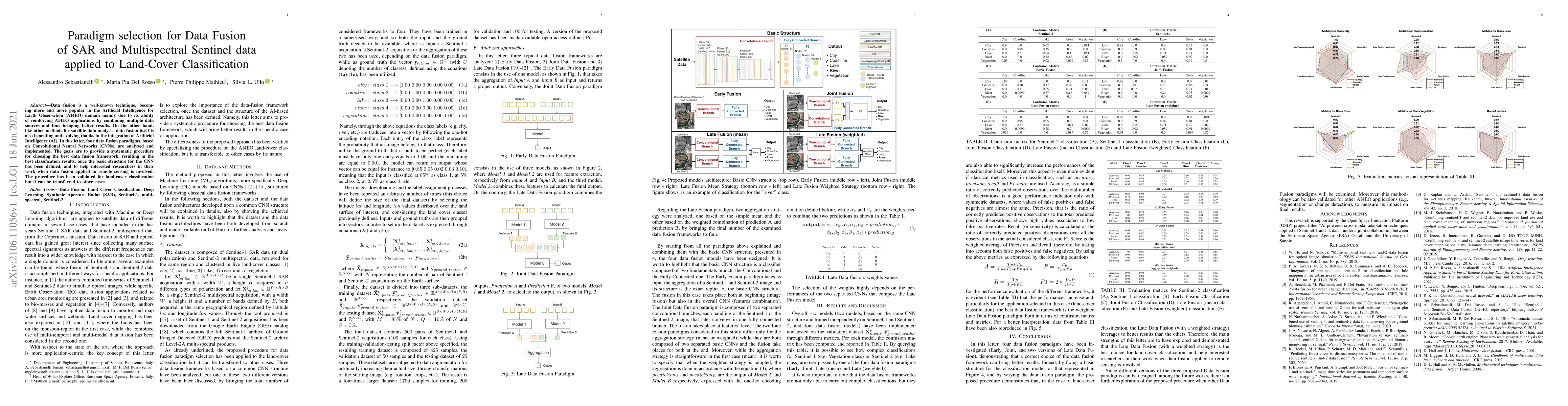
Data fusion is a well-known technique, becoming more and more popular in the Artificial Intelligence for Earth Observation (AI4EO) domain mainly due to its ability of reinforcing AI4EO applications by combining multiple data sources and thus bringing better results. On the other hand, like other methods for satellite data analysis, data fusion itself is also benefiting and evolving thanks to the integration of Artificial Intelligence (AI). In this letter, four data fusion paradigms, based on Convolutional Neural Networks (CNNs), are analyzed and implemented. The goals are to provide a systematic procedure for choosing the best data fusion framework, resulting in the best classification results, once the basic structure for the CNN has been defined, and to help interested researchers in their work when data fusion applied to remote sensing is involved. The procedure has been validated for land-cover classification but it can be transferred to other cases.
AI Key Findings
Get AI-generated insights about this paper's methodology, results, and significance.
Paper Details
PDF Preview
Key Terms
Citation Network
Current paper (gray), citations (green), references (blue)
Display is limited for performance on very large graphs.
Similar Papers
Found 4 papersSemi-supervised learning for joint SAR and multispectral land cover classification
Antonio Montanaro, Diego Valsesia, Enrico Magli et al.
Land use/land cover classification of fused Sentinel-1 and Sentinel-2 imageries using ensembles of Random Forests
Shivam Pande
Subspace-Based Feature Fusion From Hyperspectral And Multispectral Image For Land Cover Classification
Henry Arguello, Juan Ramírez, Héctor Vargas et al.
| Title | Authors | Year | Actions |
|---|
Comments (0)