ArxivLens
ArXiv physics.geo-ph cs.LG

Parametric modeling of shear wave velocity profiles for the conterminous U.S

Brett W. Maurer, Morgan D. Sanger

2510.00372 Published Oct 1, 2025
View PDF

Publication

Published: Oct 01, 2025
Categories: physics.geo-ph, cs.LG

Metrics

Source: ArXiv

Quick Answers

What methodology did the authors use?

The study compiled a national dataset of over 9,000 in-situ geotechnical measurements, including VS profiles, CPT data, and VS,30 measurements. A parametric model was developed using a functional form with three parameters (VS,2.5, k, and n) to describe VS-with-depth relationships. Geospatial machine learning was integrated to predict high-resolution VS-depth profiles across the U.S. More in Methodology →

What are the key results?

A three-parameter functional form (VS,2.5 + k(z – 2.5)^n = VS(z)) was calibrated using national geotechnical data to describe VS-depth profiles. — The model provides consistent, high-resolution VS-depth predictions for the near-surface geotechnical layer across the contiguous U.S. More in Key Results →

Why is this work significant?

This research enhances seismic hazard assessments by providing accurate, high-resolution near-surface VS-depth models that integrate with existing crustal models like the NCM. It supports physics-based ground motion simulations and improves understanding of site response for earthquake engineering applications. More in Significance →

What are the main limitations?

The model's accuracy may be limited in areas with sparse geotechnical data. — The parametric form assumes a monotonically increasing VS-depth relationship, which may not capture all subsurface complexities. More in Limitations →

Paper Preview

Abstract

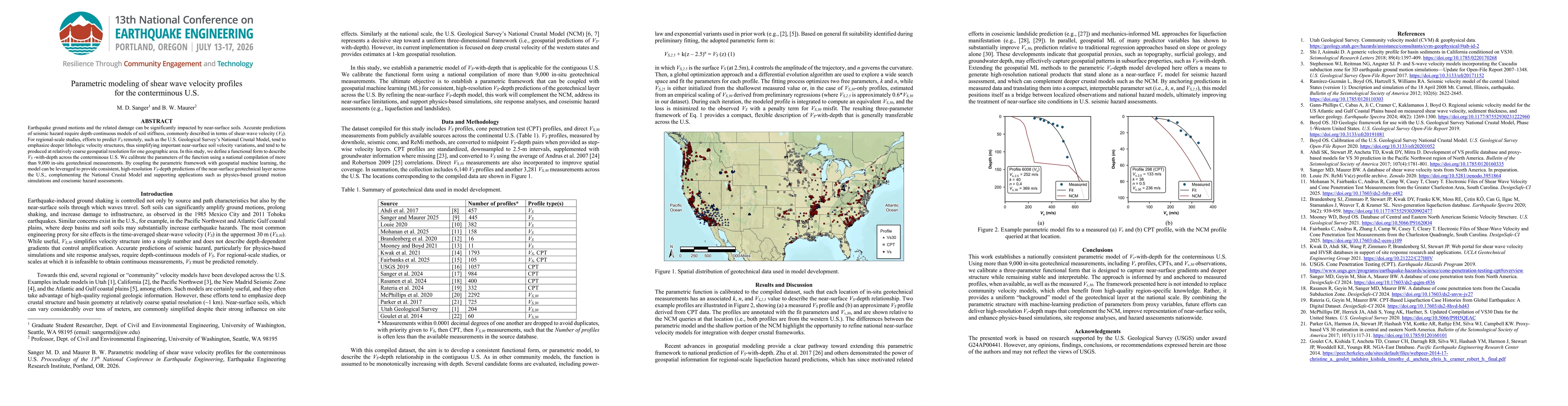
Earthquake ground motions and the related damage can be significantly impacted by near-surface soils. Accurate predictions of seismic hazard require depth-continuous models of soil stiffness, commonly described in terms of shear-wave velocity (VS). For regional-scale studies, efforts to predict VS remotely, such as the U.S. Geological Survey's National Crustal Model, tend to emphasize deeper lithologic velocity structures, thus simplifying important near-surface soil velocity variations, and tend to be produced at relatively coarse geospatial resolution for one geographic area. In this study, we define a functional form to describe VS-with-depth across the conterminous U.S. We calibrate the parameters of the function using a national compilation of more than 9,000 in-situ geotechnical measurements. By coupling the parametric framework with geospatial machine learning, the model can be leveraged to provide consistent, high resolution VS-depth predictions of the near-surface geotechnical layer across the U.S., complementing the National Crustal Model and supporting applications such as physics-based ground motion simulations and coseismic hazard assessments.

Key Findings, in focus

Seven facets of this paper, analysed and brought into focus by AI.

AI-generated · verify against source Generated Oct 05, 2025
In focus · one-line synthesis

This research enhances seismic hazard assessments by providing accurate, high-resolution near-surface VS-depth models that integrate with existing crustal models like the NCM.

01
MethodologyHow they did it

The study compiled a national dataset of over 9,000 in-situ geotechnical measurements, including VS profiles, CPT data, and VS,30 measurements. A parametric model was developed using a functional form with three parameters (VS,2.5, k, and n) to describe VS-with-depth relationships. Geospatial machine learning was integrated to predict high-resolution VS-depth profiles across the U.S.

02
ResultsWhat they found
  • A three-parameter functional form (VS,2.5 + k(z – 2.5)^n = VS(z)) was calibrated using national geotechnical data to describe VS-depth profiles.
  • The model provides consistent, high-resolution VS-depth predictions for the near-surface geotechnical layer across the contiguous U.S.
  • The parametric model complements the National Crustal Model (NCM) by addressing near-surface limitations and improving seismic hazard assessments.
03
SignificanceWhy it matters

This research enhances seismic hazard assessments by providing accurate, high-resolution near-surface VS-depth models that integrate with existing crustal models like the NCM. It supports physics-based ground motion simulations and improves understanding of site response for earthquake engineering applications.

04
Technical ContributionsWhat's new technically

A compact, interpretable three-parameter functional form was developed to describe VS-depth profiles, enabling transferable and scalable geospatial predictions across the U.S.

05
NoveltyWhat sets it apart

This work introduces a nationally consistent parametric model for VS-depth profiles, combining geotechnical measurements with geospatial machine learning to address near-surface limitations of existing crustal models.

06
LimitationsWhat to be cautious about
  • The model's accuracy may be limited in areas with sparse geotechnical data.
  • The parametric form assumes a monotonically increasing VS-depth relationship, which may not capture all subsurface complexities.
07
Future WorkWhere it goes next
  • Expanding the model to include more detailed subsurface layers beyond the near-surface geotechnical layer.
  • Integrating additional geospatial variables (e.g., topography, groundwater depth) to improve model predictions.
  • Validating the model against new geotechnical data and refining parameters for regional applications.

Paper Details

Paper ID: 2510.00372
Categories:
physics.geo-ph cs.LG

How to Cite This Paper

Reference manager: RIS EndNote


Discussion 0

This website uses cookies to ensure you get the best experience. Learn more