PaRK-Detect: Towards Efficient Multi-Task Satellite Imagery Road Extraction via Patch-Wise Keypoints Detection
Publication
Metrics
AI Quick Summary
The PaRK-Detect framework proposes a new multi-task approach for efficient satellite imagery road extraction using patch-wise road keypoints detection, achieving competitive results and significantly faster inference speed compared to existing methods. This method constructs road graphs and generates segmentation masks in a single pass, overcoming the limitations of both semantic segmentation and graph-based approaches.
Paper Preview
Abstract
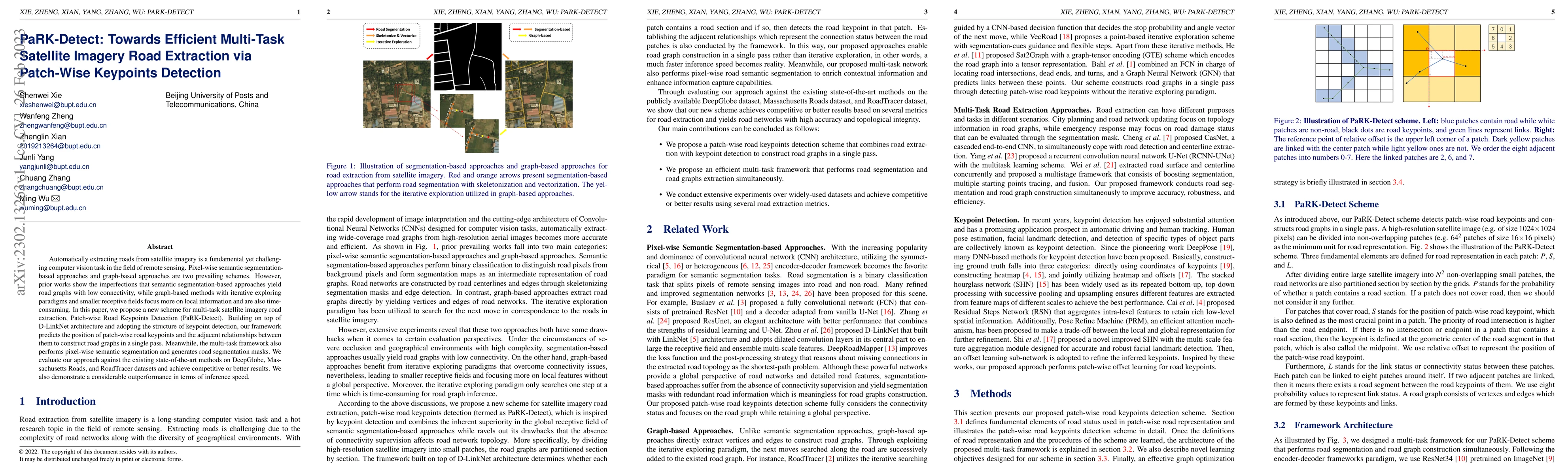
Automatically extracting roads from satellite imagery is a fundamental yet challenging computer vision task in the field of remote sensing. Pixel-wise semantic segmentation-based approaches and graph-based approaches are two prevailing schemes. However, prior works show the imperfections that semantic segmentation-based approaches yield road graphs with low connectivity, while graph-based methods with iterative exploring paradigms and smaller receptive fields focus more on local information and are also time-consuming. In this paper, we propose a new scheme for multi-task satellite imagery road extraction, Patch-wise Road Keypoints Detection (PaRK-Detect). Building on top of D-LinkNet architecture and adopting the structure of keypoint detection, our framework predicts the position of patch-wise road keypoints and the adjacent relationships between them to construct road graphs in a single pass. Meanwhile, the multi-task framework also performs pixel-wise semantic segmentation and generates road segmentation masks. We evaluate our approach against the existing state-of-the-art methods on DeepGlobe, Massachusetts Roads, and RoadTracer datasets and achieve competitive or better results. We also demonstrate a considerable outperformance in terms of inference speed.
AI Key Findings
Get AI-generated insights about this paper's methodology, results, significance, and more — seven facets brought into focus.
Impact
Paper Details
Authors
PDF Preview
Key Terms
Citation Network
Current paper (gray), citations (green), references (blue)
Display is limited for performance on very large graphs.
Discussion 0